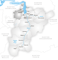
Wolfenschiessen (Wolfenschiessen)

- municipality in Switzerland
 Hiking in Wolfenschiessen
Wolfenschiessen is a charming village located in the Nidwalden region of Switzerland, nestled between the well-known mountains of the area. It's an excellent base for hiking enthusiasts due to its stunning natural scenery, well-marked trails, and access to the surrounding alpine landscapes.
Hiking Trails in Wolfenschiessen
-
Wanderung zum Mörlialp: This is a popular trail that offers beautiful views of the surrounding mountains and valleys. The hike typically starts from Wolfenschiessen and leads up to Mörlialp, where you can enjoy panoramic views.
-
Büeltenalp: This trail takes you through lush forests and meadows, leading to the scenic Büeltenalp. It’s a moderate hike, making it suitable for most hikers and families.
-
Grosser Mythen: For more experienced hikers, the trail to Grosser Mythen is challenging but rewarding, featuring breathtaking views from the summit. Keep in mind that it requires a good level of fitness and hiking experience.
-
Luzern - Engelberg Trail: Connecting Wolfenschiessen to Engelberg, this longer trek is a part of a popular hiking route. The trail takes you through varied terrain, offering a mix of wooded areas and open countryside.
Tips for Hiking in Wolfenschiessen
-
Weather Conditions: Always check the weather before heading out, as conditions can change rapidly in the mountains. Dress in layers and be prepared for rain or colder temperatures.
-
Trail Markings: Follow the designated paths and signs. Switzerland has an excellent network of marked trails, making navigation relatively straightforward.
-
Hydration and Snacks: Bring plenty of water and snacks to keep your energy up during your hikes.
-
Local Advice: Consider stopping by the local tourist information center for trail maps and current trail conditions. They can provide valuable insights and recommendations based on your skill level.
-
Respect Nature: Stay on designated trails to protect the local flora and fauna. Carry out all trash and follow Leave No Trace principles to preserve the pristine environment.
Wolfenschiessen offers a fantastic opportunity to experience the beauty of the Swiss Alps. Whether you're a beginner looking for gentle trails or an experienced hiker seeking a challenge, you'll find something to match your interests here. Enjoy your hike!
- Country:

- Postal Code: 6386
- Local Dialing Code: 041
- Licence Plate Code: NW
- Coordinates: 46° 51' 46" N, 8° 23' 40" E


- GPS tracks (wikiloc): [Link]
- AboveSeaLevel: 1516 м m
- Area: 92.76 sq km
- Population: 2093
- Web site: http://www.wolfenschiessen.ch
- Wikipedia en: wiki(en)
- Wikipedia: wiki(de)
- Wikidata storage: Wikidata: Q64351
- Wikipedia Commons Category: [Link]
- Freebase ID: [/m/01v2g7]
- GeoNames ID: Alt: [7287603]
- VIAF ID: Alt: [149071959]
- OSM relation ID: [1683122]
- MusicBrainz area ID: [858e7d2e-b3a2-4c08-9c76-07acebadae0f]
- HDS ID: [757]
- Swiss municipality code: [1511]
Shares border with regions:


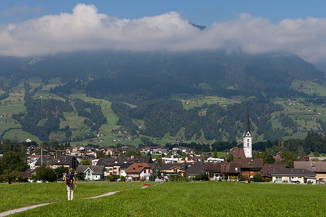
Engelberg
- municipality in Switzerland
Hiking in Engelberg
Engelberg is a picturesque mountain village located in Switzerland, nestled in the heart of the Swiss Alps. It’s renowned for its stunning landscapes, fantastic hiking trails, and as a starting point for various outdoor activities. Here are some highlights of hiking in Engelberg:...
- Country:
- Postal Code: 6390
- Local Dialing Code: 041
- Licence Plate Code: OW
- Coordinates: 46° 49' 11" N, 8° 26' 3" E
- GPS tracks (wikiloc): [Link]
- AboveSeaLevel: 1419 м m
- Area: 40.75 sq km
- Population: 4155
- Web site: [Link]


Dallenwil
- municipality in Switzerland
Hiking in Dallenwil
Dallenwil, a charming village located in the canton of Nidwalden, Switzerland, is surrounded by stunning natural landscapes that offer a variety of hiking opportunities. The area is known for its picturesque trails that cater to different skill levels, making it an attractive destination for both beginner and experienced hikers....
- Country:
- Postal Code: 6383
- Local Dialing Code: 041
- Licence Plate Code: NW
- Coordinates: 46° 55' 3" N, 8° 21' 54" E
- GPS tracks (wikiloc): [Link]
- AboveSeaLevel: 1072 м m
- Area: 15.48 sq km
- Population: 1814
- Web site: [Link]

Isenthal
- municipality in Switzerland
Hiking in Isenthal
Isenthal is a beautiful valley located in the heart of Switzerland, specifically in the canton of Uri. It is known for its stunning landscapes, lush meadows, and impressive mountain views, making it a perfect destination for hiking enthusiasts. Here are some key highlights and tips for hiking in Isenthal:...
- Country:
- Postal Code: 6461
- Local Dialing Code: 041
- Licence Plate Code: UR
- Coordinates: 46° 53' 11" N, 8° 31' 28" E
- GPS tracks (wikiloc): [Link]
- AboveSeaLevel: 1404 м m
- Area: 60.99 sq km
- Population: 494
- Web site: [Link]


Oberdorf
- municipality in the canton of Nidwalden, Switzerland
Hiking in Oberdorf
Oberdorf, located in the Nidwalden canton of Switzerland, offers a beautiful setting for hiking enthusiasts. Nestled in the central part of the country, this region is known for its stunning landscapes, including rolling hills, lush forests, and picturesque views of the surrounding mountains....
- Country:
- Postal Code: 6370
- Local Dialing Code: 041
- Licence Plate Code: NW
- Coordinates: 46° 56' 33" N, 8° 24' 21" E
- GPS tracks (wikiloc): [Link]
- AboveSeaLevel: 716 м m
- Area: 16.20 sq km
- Population: 3133
- Web site: [Link]

Kerns
- village in the canton of Obwalden, Switzerland
Hiking in Kerns
Kerns is a picturesque area in Utah, known for its stunning landscapes and outdoor recreation opportunities, including hiking. Here are some key points about hiking in Kerns:...
- Country:
- Postal Code: 6064
- Local Dialing Code: 041
- Licence Plate Code: OW
- Coordinates: 46° 50' 23" N, 8° 18' 5" E
- GPS tracks (wikiloc): [Link]
- AboveSeaLevel: 1017 м m
- Area: 92.58 sq km
- Population: 6295
- Web site: [Link]


Beckenried
- municipality in Switzerland
Hiking in Beckenried
Beckenried, located in the canton of Nidwalden, Switzerland, is a beautiful destination for hiking enthusiasts. Nestled between Lake Lucerne and the surrounding mountains, it offers a variety of trails with stunning views, diverse landscapes, and the opportunity to explore the natural beauty of the region....
- Country:
- Postal Code: 6375
- Local Dialing Code: 041
- Licence Plate Code: NW
- Coordinates: 46° 57' 59" N, 8° 28' 29" E
- GPS tracks (wikiloc): [Link]
- AboveSeaLevel: 448 м m
- Area: 32.95 sq km
- Population: 3654
- Web site: [Link]
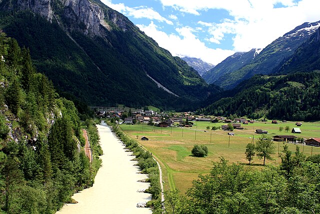

Innertkirchen
- village and municipality in the canton of Bern, Switzerland
Hiking in Innertkirchen
Innertkirchen, located in the Bernese Oberland region of Switzerland, is a fantastic destination for hiking enthusiasts. Nestled between the majestic mountains of the Alps, it offers breathtaking landscapes and a variety of trails suitable for different skill levels. Here’s what you can expect when hiking in and around Innertkirchen:...
- Country:
- Postal Code: 3862
- Local Dialing Code: 033
- Licence Plate Code: BE
- Coordinates: 46° 41' 59" N, 8° 14' 0" E
- GPS tracks (wikiloc): [Link]
- AboveSeaLevel: 625 м m
- Area: 120.0 sq km
- Population: 1076
- Web site: [Link]