Blauzac (Blauzac)

- commune in Gard, France
- Country:

- Postal Code: 30700
- Coordinates: 43° 57' 48" N, 4° 22' 8" E


- GPS tracks (wikiloc): [Link]
- Area: 15.9 sq km
- Population: 1186
- Web site: http://www.blauzac.com
- Wikipedia en: wiki(en)
- Wikipedia: wiki(fr)
- Wikidata storage: Wikidata: Q680610
- Wikipedia Commons Category: [Link]
- Freebase ID: [/m/02x2skr]
- GeoNames ID: Alt: [6448196]
- SIREN number: [213000417]
- BnF ID: [152546821]
- INSEE municipality code: 30041
Shares border with regions:


Sainte-Anastasie
- commune in Gard, France
- Country:
- Postal Code: 30190
- Coordinates: 43° 56' 7" N, 4° 19' 18" E
- GPS tracks (wikiloc): [Link]
- AboveSeaLevel: 70 м m
- Area: 43.64 sq km
- Population: 1667

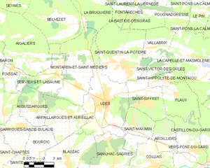
Uzès
- commune in Gard, France
- Country:
- Postal Code: 30700
- Coordinates: 44° 0' 45" N, 4° 25' 11" E
- GPS tracks (wikiloc): [Link]
- AboveSeaLevel: 275 м m
- Area: 25.41 sq km
- Population: 8540
- Web site: [Link]


Arpaillargues-et-Aureillac
- commune in Gard, France
- Country:
- Postal Code: 30700
- Coordinates: 44° 0' 2" N, 4° 22' 21" E
- GPS tracks (wikiloc): [Link]
- AboveSeaLevel: 116 м m
- Area: 13.67 sq km
- Population: 1021


Sanilhac-Sagriès
- commune in Gard, France
- Country:
- Postal Code: 30700
- Coordinates: 43° 57' 18" N, 4° 25' 28" E
- GPS tracks (wikiloc): [Link]
- AboveSeaLevel: 105 м m
- Area: 22.1 sq km
- Population: 832

Bourdic
- commune in Gard, France
- Country:
- Postal Code: 30190
- Coordinates: 43° 59' 0" N, 4° 19' 51" E
- GPS tracks (wikiloc): [Link]
- Area: 7.34 sq km
- Population: 386