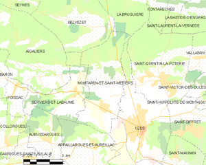
canton of Uzès (canton d'Uzès)

- canton of France
- Country:

- Capital: Uzès
- Coordinates: 44° 1' 0" N, 4° 25' 0" E


- GPS tracks (wikiloc): [Link]
- Population: 31910
- Wikipedia en: wiki(en)
- Wikipedia: wiki(fr)
- Wikidata storage: Wikidata: Q1597343
- INSEE canton code: [3020]
Includes regions:

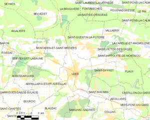
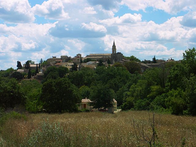
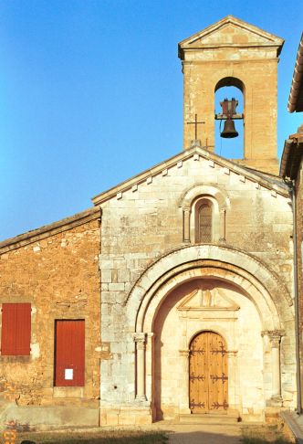
Uzès
- commune in Gard, France
- Country:
- Postal Code: 30700
- Coordinates: 44° 0' 45" N, 4° 25' 11" E
- GPS tracks (wikiloc): [Link]
- AboveSeaLevel: 275 м m
- Area: 25.41 sq km
- Population: 8540
- Web site: [Link]
Saint-Hippolyte-de-Montaigu
- commune in Gard, France
- Country:
- Postal Code: 30700
- Coordinates: 44° 1' 56" N, 4° 29' 34" E
- GPS tracks (wikiloc): [Link]
- Area: 4.05 sq km
- Population: 253


Saint-Maximin
- commune in Gard, France
- Country:
- Postal Code: 30700
- Coordinates: 43° 59' 38" N, 4° 27' 3" E
- GPS tracks (wikiloc): [Link]
- Area: 9.9 sq km
- Population: 711
Flaux
- commune in Gard, France
- Country:
- Postal Code: 30700
- Coordinates: 44° 1' 14" N, 4° 30' 13" E
- GPS tracks (wikiloc): [Link]
- Area: 10.68 sq km
- Population: 358


Arpaillargues-et-Aureillac
- commune in Gard, France
- Country:
- Postal Code: 30700
- Coordinates: 44° 0' 2" N, 4° 22' 21" E
- GPS tracks (wikiloc): [Link]
- AboveSeaLevel: 116 м m
- Area: 13.67 sq km
- Population: 1021


La Capelle-et-Masmolène
- commune in Gard, France
- Country:
- Postal Code: 30700
- Coordinates: 44° 3' 5" N, 4° 31' 42" E
- GPS tracks (wikiloc): [Link]
- Area: 24.45 sq km
- Population: 450


Sanilhac-Sagriès
- commune in Gard, France
- Country:
- Postal Code: 30700
- Coordinates: 43° 57' 18" N, 4° 25' 28" E
- GPS tracks (wikiloc): [Link]
- AboveSeaLevel: 105 м m
- Area: 22.1 sq km
- Population: 832


Saint-Quentin-la-Poterie
- commune in Gard, France
- Country:
- Postal Code: 30700
- Coordinates: 44° 2' 43" N, 4° 26' 28" E
- GPS tracks (wikiloc): [Link]
- Area: 24.06 sq km
- Population: 3035
- Web site: [Link]

Blauzac
- commune in Gard, France
- Country:
- Postal Code: 30700
- Coordinates: 43° 57' 48" N, 4° 22' 8" E
- GPS tracks (wikiloc): [Link]
- Area: 15.9 sq km
- Population: 1186
- Web site: [Link]

Aigaliers
- commune in Gard, France
- Country:
- Postal Code: 30700
- Coordinates: 44° 3' 34" N, 4° 19' 13" E
- GPS tracks (wikiloc): [Link]
- Area: 28.06 sq km
- Population: 490


Saint-Victor-des-Oules
- commune in Gard, France
- Country:
- Postal Code: 30700
- Coordinates: 44° 2' 31" N, 4° 29' 2" E
- GPS tracks (wikiloc): [Link]
- Area: 4.77 sq km
- Population: 310
Serviers-et-Labaume
- commune in Gard, France
- Country:
- Postal Code: 30700
- Coordinates: 44° 2' 15" N, 4° 21' 19" E
- GPS tracks (wikiloc): [Link]
- Area: 12.22 sq km
- Population: 596
Vallabrix
- commune in Gard, France
- Country:
- Postal Code: 30700
- Coordinates: 44° 3' 41" N, 4° 28' 43" E
- GPS tracks (wikiloc): [Link]
- Area: 7.94 sq km
- Population: 418

Montaren-et-Saint-Médiers
- commune in Gard, France
- Country:
- Postal Code: 30700
- Coordinates: 44° 1' 48" N, 4° 22' 47" E
- GPS tracks (wikiloc): [Link]
- Area: 19.42 sq km
- Population: 1454


Saint-Siffret
- commune in Gard, France
- Country:
- Postal Code: 30700
- Coordinates: 44° 1' 2" N, 4° 27' 58" E
- GPS tracks (wikiloc): [Link]
- Area: 11.28 sq km
- Population: 1036