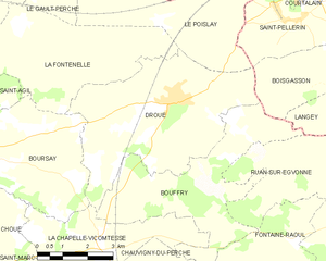
Bouffry (Bouffry)

- commune in Loir-et-Cher, France
- Country:

- Postal Code: 41270
- Coordinates: 48° 0' 29" N, 1° 5' 51" E


- GPS tracks (wikiloc): [Link]
- Area: 17.73 sq km
- Population: 140
- Wikipedia en: wiki(en)
- Wikipedia: wiki(fr)
- Wikidata storage: Wikidata: Q1135662
- Wikipedia Commons Category: [Link]
- Freebase ID: [/m/03nv_43]
- GeoNames ID: Alt: [3031290]
- SIREN number: [214100224]
- BnF ID: [15259298h]
- INSEE municipality code: 41022
Shares border with regions:


Boisgasson
- former commune in Eure-et-Loir, France
- Country:
- Postal Code: 28220
- Coordinates: 48° 2' 51" N, 1° 9' 9" E
- GPS tracks (wikiloc): [Link]
- AboveSeaLevel: 157 м m
- Area: 7.5 sq km
- Population: 115
Chauvigny-du-Perche
- commune in Loir-et-Cher, France
- Country:
- Postal Code: 41270
- Coordinates: 47° 57' 29" N, 1° 4' 47" E
- GPS tracks (wikiloc): [Link]
- Area: 23.43 sq km
- Population: 225
Langey
- former commune in Eure-et-Loir, France
- Country:
- Postal Code: 28220
- Coordinates: 48° 2' 36" N, 1° 11' 10" E
- GPS tracks (wikiloc): [Link]
- Area: 19.48 sq km
- Population: 351


Fontaine-Raoul
- commune in Loir-et-Cher, France
- Country:
- Postal Code: 41270
- Coordinates: 47° 59' 26" N, 1° 8' 20" E
- GPS tracks (wikiloc): [Link]
- Area: 21.9 sq km
- Population: 210

Droué
- commune in Loir-et-Cher, France
- Country:
- Postal Code: 41270
- Coordinates: 48° 2' 26" N, 1° 4' 34" E
- GPS tracks (wikiloc): [Link]
- Area: 24.04 sq km
- Population: 986
- Web site: [Link]
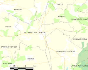
La Chapelle-Vicomtesse
- commune in Loir-et-Cher, France
- Country:
- Postal Code: 41270
- Coordinates: 47° 59' 27" N, 1° 2' 8" E
- GPS tracks (wikiloc): [Link]
- Area: 15.03 sq km
- Population: 180
Ruan-sur-Egvonne
- commune in Loir-et-Cher, France
- Country:
- Postal Code: 41270
- Coordinates: 48° 0' 48" N, 1° 8' 44" E
- GPS tracks (wikiloc): [Link]
- Area: 11.35 sq km
- Population: 94