Fontaine-Raoul (Fontaine-Raoul)

- commune in Loir-et-Cher, France
- Country:

- Postal Code: 41270
- Coordinates: 47° 59' 26" N, 1° 8' 20" E


- GPS tracks (wikiloc): [Link]
- Area: 21.9 sq km
- Population: 210
- Wikipedia en: wiki(en)
- Wikipedia: wiki(fr)
- Wikidata storage: Wikidata: Q1170367
- Wikipedia Commons Category: [Link]
- Freebase ID: [/m/03nw01p]
- GeoNames ID: Alt: [3018015]
- SIREN number: [214100885]
- BnF ID: [15259364g]
- INSEE municipality code: 41088
Shares border with regions:
Chauvigny-du-Perche
- commune in Loir-et-Cher, France
- Country:
- Postal Code: 41270
- Coordinates: 47° 57' 29" N, 1° 4' 47" E
- GPS tracks (wikiloc): [Link]
- Area: 23.43 sq km
- Population: 225
Bouffry
- commune in Loir-et-Cher, France
- Country:
- Postal Code: 41270
- Coordinates: 48° 0' 29" N, 1° 5' 51" E
- GPS tracks (wikiloc): [Link]
- Area: 17.73 sq km
- Population: 140

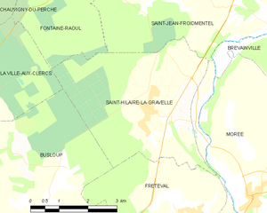
Saint-Hilaire-la-Gravelle
- commune in Loir-et-Cher, France
- Country:
- Postal Code: 41160
- Coordinates: 47° 55' 28" N, 1° 12' 24" E
- GPS tracks (wikiloc): [Link]
- Area: 17.57 sq km
- Population: 716


Saint-Jean-Froidmentel
- commune in Loir-et-Cher, France
- Country:
- Postal Code: 41160
- Coordinates: 47° 57' 24" N, 1° 14' 23" E
- GPS tracks (wikiloc): [Link]
- Area: 17.2 sq km
- Population: 529
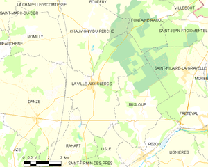
La Ville-aux-Clercs
- commune in Loir-et-Cher, France
- Country:
- Postal Code: 41160
- Coordinates: 47° 55' 6" N, 1° 5' 6" E
- GPS tracks (wikiloc): [Link]
- Area: 26.61 sq km
- Population: 1299
Villebout
- commune in Loir-et-Cher, France
- Country:
- Postal Code: 41270
- Coordinates: 47° 59' 22" N, 1° 10' 41" E
- GPS tracks (wikiloc): [Link]
- Area: 11.21 sq km
- Population: 142
Ruan-sur-Egvonne
- commune in Loir-et-Cher, France
- Country:
- Postal Code: 41270
- Coordinates: 48° 0' 48" N, 1° 8' 44" E
- GPS tracks (wikiloc): [Link]
- Area: 11.35 sq km
- Population: 94