Droué (Droué)

- commune in Loir-et-Cher, France
- Country:

- Postal Code: 41270
- Coordinates: 48° 2' 26" N, 1° 4' 34" E


- GPS tracks (wikiloc): [Link]
- Area: 24.04 sq km
- Population: 986
- Web site: http://www.droue.com
- Wikipedia en: wiki(en)
- Wikipedia: wiki(fr)
- Wikidata storage: Wikidata: Q1382094
- Wikipedia Commons Category: [Link]
- Freebase ID: [/m/03hgv1s]
- GeoNames ID: Alt: [3020771]
- SIREN number: [214100752]
- BnF ID: [152593514]
- Library of Congress authority ID: Alt: [nr93004501]
- INSEE municipality code: 41075
Shares border with regions:


Boisgasson
- former commune in Eure-et-Loir, France
- Country:
- Postal Code: 28220
- Coordinates: 48° 2' 51" N, 1° 9' 9" E
- GPS tracks (wikiloc): [Link]
- AboveSeaLevel: 157 м m
- Area: 7.5 sq km
- Population: 115


La Fontenelle
- commune in Loir-et-Cher, France
- Country:
- Postal Code: 41270
- Coordinates: 48° 3' 36" N, 1° 1' 28" E
- GPS tracks (wikiloc): [Link]
- Area: 20.1 sq km
- Population: 193

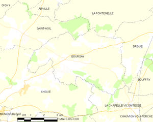
Boursay
- commune in Loir-et-Cher, France
- Country:
- Postal Code: 41270
- Coordinates: 48° 1' 9" N, 0° 58' 9" E
- GPS tracks (wikiloc): [Link]
- Area: 22.08 sq km
- Population: 173
Bouffry
- commune in Loir-et-Cher, France
- Country:
- Postal Code: 41270
- Coordinates: 48° 0' 29" N, 1° 5' 51" E
- GPS tracks (wikiloc): [Link]
- Area: 17.73 sq km
- Population: 140


Le Poislay
- commune in Loir-et-Cher, France
- Country:
- Postal Code: 41270
- Coordinates: 48° 4' 2" N, 1° 3' 59" E
- GPS tracks (wikiloc): [Link]
- Area: 15.89 sq km
- Population: 189
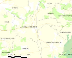
La Chapelle-Vicomtesse
- commune in Loir-et-Cher, France
- Country:
- Postal Code: 41270
- Coordinates: 47° 59' 27" N, 1° 2' 8" E
- GPS tracks (wikiloc): [Link]
- Area: 15.03 sq km
- Population: 180