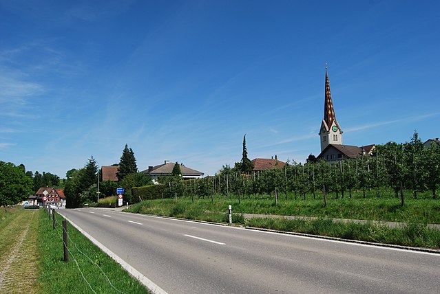
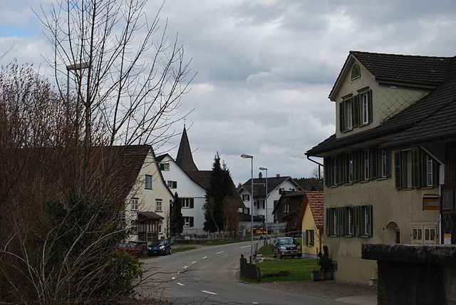
Braunau (Braunau TG)

- municipality in Switzerland
 Hiking in Braunau
Braunau, while not a well-known hiking destination itself, is located in Switzerland near the borders of more prominent hiking areas, particularly in the region of the Swiss Alps. However, it provides access to various scenic trails and the surrounding natural beauty that the Swiss landscape offers.
Key Areas for Hiking Near Braunau:
-
Alps Region: The Swiss Alps feature numerous hiking trails of varying difficulties, from leisurely walks to challenging mountain routes. Look for trails with spectacular views of the peaks, glaciers, and valleys.
-
Regional Parks: Close to Braunau, you'll find several regional parks with designated hiking paths. These parks often provide well-marked trails and information about the local flora and fauna.
-
Lakes and Rivers: The area surrounding Braunau may also include picturesque lakes and rivers, offering trails that feature waterfront views and tranquil settings. Hiking along a lake can be a fantastic way to experience the landscape.
Hiking Tips:
-
Trail Maps: Obtain local trail maps from tourist information centers or local hiking clubs to find the best routes and get important information about difficulty levels.
-
Weather Preparedness: Always check the weather conditions before heading out. The weather in the mountains can change rapidly.
-
Gear Up Properly: Invest in a good pair of hiking shoes, and consider wearing layered clothing to accommodate changing temperatures.
-
Hydration and Snacks: Always carry water and some snacks to keep your energy levels up during your hike.
-
Stay on Marked Trails: For safety and to preserve the natural environment, stick to marked hiking trails.
Suggested Trails:
While specific trail information around Braunau may be limited, consider visiting nearby towns or national parks known for their trails. For instance, routes in the vicinity of Lucerne or Interlaken might be ideal for day hikes.
Local Attractions:
If you have time to explore, the cultural and historical aspects of the surrounding areas, including quaint villages and local cuisine, can enhance your hiking trip.
Always check local regulations, maps, and current conditions before setting out to ensure a safe and enjoyable hiking experience. Happy hiking!
- Country:

- Postal Code: 9502
- Local Dialing Code: 071
- Licence Plate Code: TG
- Coordinates: 47° 30' 16" N, 9° 4' 8" E


- GPS tracks (wikiloc): [Link]
- AboveSeaLevel: 693 м m
- Area: 9.2 sq km
- Population: 770
- Web site: http://www.braunau.ch
- Wikipedia en: wiki(en)
- Wikipedia: wiki(de)
- Wikidata storage: Wikidata: Q69702
- Wikipedia Commons Category: [Link]
- Freebase ID: [/m/0g350v]
- GeoNames ID: Alt: [7285319]
- VIAF ID: Alt: [237448364]
- HDS ID: [1967]
- Swiss municipality code: [4723]
Shares border with regions:


Wil
- municipality in the canton of St. Gallen, Switzerland
Hiking in Wil
Wil is a beautiful town in the canton of St. Gallen, Switzerland, known for its picturesque landscapes and access to hiking trails that cater to various skill levels. The region offers a mix of easy walks and more challenging hikes, often featuring stunning views of the surrounding hills and the nearby Appenzell region....
- Country:
- Postal Code: 9500
- Local Dialing Code: 071
- Licence Plate Code: SG
- Coordinates: 47° 27' 59" N, 9° 2' 59" E
- GPS tracks (wikiloc): [Link]
- AboveSeaLevel: 571 м m
- Area: 20.7 sq km
- Population: 23768
- Web site: [Link]

Wuppenau
- municipality in Switzerland
Hiking in Wuppenau
Wuppenau is a relatively lesser-known area, which might not be as popular as some larger hiking destinations, but it can offer an enjoyable experience for those looking to explore its natural beauty. Here are some general tips and insights for hiking in the Wuppenau area:...
- Country:
- Postal Code: 9514
- Local Dialing Code: 071
- Licence Plate Code: TG
- Coordinates: 47° 29' 41" N, 9° 7' 10" E
- GPS tracks (wikiloc): [Link]
- AboveSeaLevel: 696 м m
- Area: 12.1 sq km
- Population: 1126
- Web site: [Link]
Affeltrangen
- municipality in Switzerland
Hiking in Affeltrangen
Affeltrangen is a picturesque village located in the canton of Thurgau, Switzerland. The surrounding region offers a variety of hiking opportunities that cater to different skill levels and preferences. Here are some highlights about hiking in and around Affeltrangen:...
- Country:
- Postal Code: 9556
- Local Dialing Code: 071
- Licence Plate Code: TG
- Coordinates: 47° 30' 59" N, 9° 1' 0" E
- GPS tracks (wikiloc): [Link]
- AboveSeaLevel: 489 м m
- Area: 14.4 sq km
- Population: 2562
- Web site: [Link]


Tobel-Tägerschen
- municipality in Switzerland
Hiking in Tobel-Tägerschen
Tobel-Tägerschen is a scenic area in Switzerland that offers various hiking opportunities amidst beautiful landscapes. Located in the region of Thurgau, it features rolling hills, lush forests, and charming glimpses of rural life. Here are a few highlights and tips for hiking in that region:...
- Country:
- Postal Code: 9555
- Local Dialing Code: 071
- Licence Plate Code: TG
- Coordinates: 47° 31' 0" N, 9° 1' 59" E
- GPS tracks (wikiloc): [Link]
- AboveSeaLevel: 525 м m
- Area: 7.0 sq km
- Population: 1599
- Web site: [Link]

Bussnang
- municipality in Switzerland
Hiking in Bussnang
Bussnang is a picturesque municipality located in the canton of Thurgau, Switzerland. It is surrounded by beautiful landscapes, making it an ideal destination for hiking enthusiasts. Here are some highlights of hiking in and around Bussnang:...
- Country:
- Postal Code: 9565
- Local Dialing Code: 071
- Licence Plate Code: TG
- Coordinates: 47° 33' 30" N, 9° 5' 2" E
- GPS tracks (wikiloc): [Link]
- AboveSeaLevel: 445 м m
- Area: 19.0 sq km
- Population: 2319
- Web site: [Link]
Schönholzerswilen
- municipality in Switzerland
Hiking in Schönholzerswilen
Schönholzerswilen is a small village located in the canton of Thurgau, Switzerland. It is surrounded by beautiful landscapes that offer various hiking opportunities for outdoor enthusiasts. Here are some highlights for hiking in and around Schönholzerswilen:...
- Country:
- Postal Code: 8577
- Local Dialing Code: 071
- Licence Plate Code: TG
- Coordinates: 47° 30' 59" N, 9° 8' 25" E
- GPS tracks (wikiloc): [Link]
- AboveSeaLevel: 586 м m
- Area: 10.9 sq km
- Population: 845
- Web site: [Link]