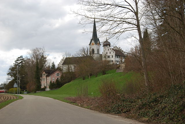
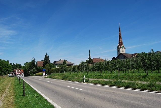
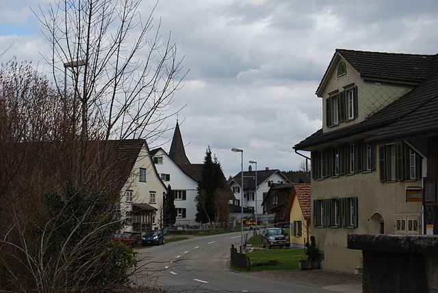
Bussnang (Bussnang)

- municipality in Switzerland
 Hiking in Bussnang
Bussnang is a picturesque municipality located in the canton of Thurgau, Switzerland. It is surrounded by beautiful landscapes, making it an ideal destination for hiking enthusiasts. Here are some highlights of hiking in and around Bussnang:
Scenic Trails
-
Landschaftsschutzgebiet Bussnang: This area offers a variety of trails that traverse stunning rural landscapes, woodlands, and agricultural fields. Hikers can enjoy the tranquility of nature and the rich biodiversity of the region.
-
Nearby Hills and Woods: The hills around Bussnang, such as the Alps of Thurgau, provide numerous trails ranging from easy walks to more challenging hikes that lead to viewpoints offering panoramic vistas of the surrounding countryside and Lake Constance.
-
Wildlife Viewing: The area is rich in flora and fauna. Keep an eye out for local wildlife, including deer and various bird species, while on your hikes.
Difficulty Levels
Hikes in this area cater to different skill levels, from gentle family walks suitable for children to more challenging routes for experienced hikers. Always check trail markers and local maps for the best routes.
Seasonal Hiking
- Spring and Summer: The trails are lush and vibrant, with wildflowers blooming and perfect for day hikes and picnics.
- Autumn: The changing colors of the leaves provide a breathtaking backdrop for hikers.
- Winter: While Bussnang may not have extensive winter sports facilities, some trails remain accessible for winter hiking, provided the conditions permit.
Practical Tips
- Navigation: Carry a map or GPS device, as some trails can be less marked.
- Weather Preparation: Weather can change quickly in the Swiss countryside; dress in layers and be prepared for rain.
- Respect Nature: Follow local guidelines for wildlife protection and keep to designated trails to preserve the natural beauty of the area.
Getting There
Bussnang is accessible by public transportation, with train services connecting it to larger towns and cities in the region. This makes it easy to start your hiking adventures without the need for a car.
Overall, Bussnang and its surroundings offer a peaceful hiking experience, perfect for a day trip or a weekend retreat into nature. Enjoy your hiking adventure!
- Country:

- Postal Code: 9565
- Local Dialing Code: 071
- Licence Plate Code: TG
- Coordinates: 47° 33' 30" N, 9° 5' 2" E


- GPS tracks (wikiloc): [Link]
- AboveSeaLevel: 445 м m
- Area: 19.0 sq km
- Population: 2319
- Web site: http://www.bussnang.ch
- Wikipedia en: wiki(en)
- Wikipedia: wiki(de)
- Wikidata storage: Wikidata: Q65983
- Wikipedia Commons Category: [Link]
- Freebase ID: [/m/0g2gq_]
- GeoNames ID: Alt: [8505043]
- VIAF ID: Alt: [249409851]
- OSM relation ID: [1684511]
- HDS ID: [2013]
- Swiss municipality code: [4921]
- Digital Atlas of the Roman Empire ID: [38491]
Shares border with regions:
Bürglen
- municipality in Switzerland
Hiking in Bürglen
Bürglen is a charming village located in the Thurgau canton of Switzerland, known for its picturesque landscapes and scenic views. Hiking in this area offers a wonderful opportunity to experience the natural beauty of the region, including rolling hills, vineyards, and lush forests....
- Country:
- Postal Code: 8575
- Local Dialing Code: 071
- Licence Plate Code: TG
- Coordinates: 47° 32' 59" N, 9° 8' 59" E
- GPS tracks (wikiloc): [Link]
- AboveSeaLevel: 441 м m
- Area: 11.7 sq km
- Population: 3788
- Web site: [Link]

Amlikon-Bissegg
- municipality in Switzerland
Hiking in Amlikon-Bissegg
Amlikon-Bissegg is a picturesque area in Switzerland, known for its beautiful landscapes and tranquil hiking trails. Located in the canton of Thurgau, it offers a wonderful mix of nature, farms, and rural charm, making it an excellent destination for hikers of all levels....
- Country:
- Postal Code: 8514
- Local Dialing Code: 071
- Licence Plate Code: TG
- Coordinates: 47° 33' 59" N, 9° 2' 59" E
- GPS tracks (wikiloc): [Link]
- AboveSeaLevel: 422 м m
- Area: 14.4 sq km
- Population: 1335
- Web site: [Link]
Affeltrangen
- municipality in Switzerland
Hiking in Affeltrangen
Affeltrangen is a picturesque village located in the canton of Thurgau, Switzerland. The surrounding region offers a variety of hiking opportunities that cater to different skill levels and preferences. Here are some highlights about hiking in and around Affeltrangen:...
- Country:
- Postal Code: 9556
- Local Dialing Code: 071
- Licence Plate Code: TG
- Coordinates: 47° 30' 59" N, 9° 1' 0" E
- GPS tracks (wikiloc): [Link]
- AboveSeaLevel: 489 м m
- Area: 14.4 sq km
- Population: 2562
- Web site: [Link]

Weinfelden
- municipality in Switzerland
Hiking in Weinfelden
Weinfelden, located in the canton of Thurgau in Switzerland, offers a variety of hiking opportunities that showcase the beautiful landscapes of the area, including vineyards, rolling hills, and views of the nearby Bodensee (Lake Constance). Here are some highlights about hiking in Weinfelden:...
- Country:
- Postal Code: 8570
- Local Dialing Code: 071
- Licence Plate Code: TG
- Coordinates: 47° 33' 59" N, 9° 6' 0" E
- GPS tracks (wikiloc): [Link]
- AboveSeaLevel: 432 м m
- Area: 15.48 sq km
- Population: 11388
- Web site: [Link]
Schönholzerswilen
- municipality in Switzerland
Hiking in Schönholzerswilen
Schönholzerswilen is a small village located in the canton of Thurgau, Switzerland. It is surrounded by beautiful landscapes that offer various hiking opportunities for outdoor enthusiasts. Here are some highlights for hiking in and around Schönholzerswilen:...
- Country:
- Postal Code: 8577
- Local Dialing Code: 071
- Licence Plate Code: TG
- Coordinates: 47° 30' 59" N, 9° 8' 25" E
- GPS tracks (wikiloc): [Link]
- AboveSeaLevel: 586 м m
- Area: 10.9 sq km
- Population: 845
- Web site: [Link]


Braunau
- municipality in Switzerland
Hiking in Braunau
Braunau, while not a well-known hiking destination itself, is located in Switzerland near the borders of more prominent hiking areas, particularly in the region of the Swiss Alps. However, it provides access to various scenic trails and the surrounding natural beauty that the Swiss landscape offers....
- Country:
- Postal Code: 9502
- Local Dialing Code: 071
- Licence Plate Code: TG
- Coordinates: 47° 30' 16" N, 9° 4' 8" E
- GPS tracks (wikiloc): [Link]
- AboveSeaLevel: 693 м m
- Area: 9.2 sq km
- Population: 770
- Web site: [Link]