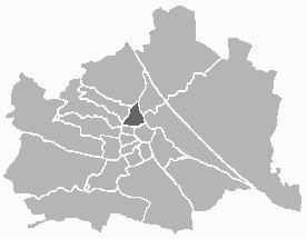
Brigittenau (Brigittenau)

- 20. district of Vienna
 Hiking in Brigittenau
Brigittenau is a 20th district of Vienna, Austria, situated on the northern banks of the Danube Canal. While it is an urban area and not traditionally associated with hiking, it still offers some opportunities for walking and enjoying the outdoors. Here are some aspects to consider if you’re interested in hiking or walking in and around Brigittenau:
-
Danube Canal Promenade: You can enjoy a scenic walk or cycle along the Danube Canal. There are pathways lined with trees and occasional parks where you can relax. The views of the water and the cityscape can be quite enjoyable.
-
Parks and Green Spaces: Within Brigittenau, there are several small parks, such as the Hermann-Gmeiner Park, where you can enjoy green spaces. While these are not hiking trails, they provide a nice place for leisurely walks or picnics.
-
Nearby Hiking Areas: For more traditional hiking experiences, you can venture outside of Brigittenau. The Wienerwald (Vienna Woods) is a short distance away and offers a variety of hiking trails in a more natural setting, complete with forests, hills, and scenic views of Vienna and the surrounding area.
-
Public Transport Access: If you're looking to explore hiking trails that are farther away, use Vienna’s excellent public transport system to access more remote areas. Trains and buses can take you to nearby hiking regions easily.
-
Riverbank Trails: Depending on the season, the riverside paths along the Danube and the canals provide opportunities for long walks, jogging, or cycling, allowing you to enjoy nature without straying too far from the city.
In summary, while Brigittenau itself may not offer extensive hiking trails, it has access to urban walks and is conveniently located for reaching more diverse hiking areas in the Vienna Woods and beyond. Always remember to check the weather and join local hiking groups if you're unfamiliar with the area for safety and community!
- Country:

- Postal Code: 1200
- Licence Plate Code: W
- Coordinates: 48° 14' 12" N, 16° 22' 10" E


- GPS tracks (wikiloc): [Link]
- AboveSeaLevel: 165 м m
- Area: 5.67 sq km
- Web site: http://www.wien.gv.at/bezirke/brigittenau/
- Wikipedia en: wiki(en)
- Wikipedia: wiki(de)
- Wikidata storage: Wikidata: Q265655
- Wikipedia Commons Gallery: [Link]
- Wikipedia Commons Category: [Link]
- Freebase ID: [/m/06qqhl]
- GeoNames ID: Alt: [2781400]
- VIAF ID: Alt: [265692007]
- GND ID: Alt: [4108149-3]
- archINFORM location ID: [3700]
- Library of Congress authority ID: Alt: [n86029563]
- TGN ID: [1004170]
- Austrian municipality key: [92001]
Shares border with regions:

Alsergrund
- 9. district of Vienna
Hiking in Alsergrund
Alsergrund is one of the 23 districts of Vienna, Austria, and while it's not primarily known for hiking in the traditional sense of wilderness trails, it does offer some enjoyable walking opportunities, particularly for urban hiking or strolling through green spaces....
- Country:
- Postal Code: 1090
- Licence Plate Code: W
- Coordinates: 48° 13' 31" N, 16° 21' 25" E
- GPS tracks (wikiloc): [Link]
- AboveSeaLevel: 179 м m
- Area: 2.99 sq km
- Web site: [Link]


Leopoldstadt
- 2nd municipal District of Vienna, Austria
Hiking in Leopoldstadt
Leopoldstadt is the second district of Vienna, Austria, known for its vibrant culture, parks, and proximity to the Danube River. While it may not offer traditional hiking trails found in mountainous regions, there are still great opportunities for outdoor activities and leisurely walks....
- Country:
- Postal Code: 1020
- Licence Plate Code: W
- Coordinates: 48° 12' 37" N, 16° 24' 44" E
- GPS tracks (wikiloc): [Link]
- AboveSeaLevel: 158 м m
- Area: 19.27 sq km
- Web site: [Link]

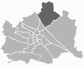
Floridsdorf
- 21. district of Vienna
Hiking in Floridsdorf
Floridsdorf is one of the 23 districts of Vienna, Austria, and while it is primarily an urban area, there are some lovely opportunities for outdoor activities and hiking in and around the district. Here are some highlights for hiking enthusiasts:...
- Country:
- Postal Code: 1210
- Licence Plate Code: W
- Coordinates: 48° 17' 0" N, 16° 24' 44" E
- GPS tracks (wikiloc): [Link]
- AboveSeaLevel: 159 м m
- Area: 44.52 sq km
- Web site: [Link]


Döbling
- 19. district of Vienna
Hiking in Döbling
Döbling is a charming district in Vienna, Austria, known for its scenic landscapes, vineyards, and proximity to the Vienna Woods (Wienerwald). Here are some highlights and tips for hiking in Döbling:...
- Country:
- Postal Code: 1190
- Licence Plate Code: W
- Coordinates: 48° 15' 59" N, 16° 19' 22" E
- GPS tracks (wikiloc): [Link]
- AboveSeaLevel: 247 м m
- Area: 24.9 sq km
- Web site: [Link]