
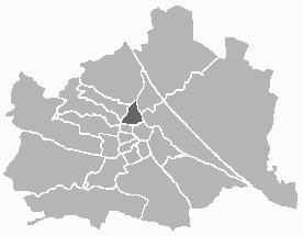
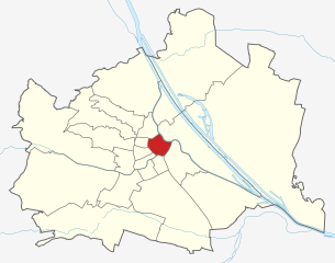
Leopoldstadt (Leopoldstadt)

- 2nd municipal District of Vienna, Austria
 Hiking in Leopoldstadt
Leopoldstadt is the second district of Vienna, Austria, known for its vibrant culture, parks, and proximity to the Danube River. While it may not offer traditional hiking trails found in mountainous regions, there are still great opportunities for outdoor activities and leisurely walks.
-
Prater Park: This expansive public park is one of the main highlights of Leopoldstadt. You can explore its many winding paths, open spaces, and the famous giant Ferris wheel. The park also features areas for cycling and rollerblading.
-
Danube Island (Donauinsel): This artificial island stretches for 21 kilometers along the Danube River and provides an excellent location for walking, biking, and enjoying nature. There are trails along the riverbanks and plenty of spots to relax, picnic, or swim.
-
Kahlenberg Hill: A bit further out, but accessible from Leopoldstadt, Kahlenberg offers hiking opportunities with stunning views of Vienna. The trails range from easy to moderate, and the summit is a popular spot for both locals and visitors.
-
Lobau National Park: Located a short distance from Leopoldstadt, this park features a network of trails through wetlands, forests, and meadows. It’s a great place for birdwatching and enjoying diverse flora and fauna.
-
Urban Hiking: In addition to natural settings, consider exploring the urban landscape of Leopoldstadt. Walk through its charming streets, visit local markets, and stop by cultural landmarks.
Remember to stay hydrated, wear comfortable shoes, and enjoy the combination of nature and city life that Leopoldstadt offers!
- Country:

- Postal Code: 1020
- Licence Plate Code: W
- Coordinates: 48° 12' 37" N, 16° 24' 44" E


- GPS tracks (wikiloc): [Link]
- AboveSeaLevel: 158 м m
- Area: 19.27 sq km
- Web site: https://www.wien.gv.at/bezirke/leopoldstadt/
- Wikipedia en: wiki(en)
- Wikipedia: wiki(de)
- Wikidata storage: Wikidata: Q259120
- Wikipedia Commons Gallery: [Link]
- Wikipedia Commons Category: [Link]
- Freebase ID: [/m/01fv9h]
- GeoNames ID: Alt: [2772614]
- VIAF ID: Alt: [124398477]
- GND ID: Alt: [4108160-2]
- archINFORM location ID: [3682]
- Library of Congress authority ID: Alt: [n85110452]
- MusicBrainz area ID: [f9e58a6f-35a2-4cd9-b917-8d574232ab00]
- Encyclopædia Britannica Online ID: [place/Leopoldstadt]
- Austrian municipality key: [90201]
Shares border with regions:

Alsergrund
- 9. district of Vienna
Hiking in Alsergrund
Alsergrund is one of the 23 districts of Vienna, Austria, and while it's not primarily known for hiking in the traditional sense of wilderness trails, it does offer some enjoyable walking opportunities, particularly for urban hiking or strolling through green spaces....
- Country:
- Postal Code: 1090
- Licence Plate Code: W
- Coordinates: 48° 13' 31" N, 16° 21' 25" E
- GPS tracks (wikiloc): [Link]
- AboveSeaLevel: 179 м m
- Area: 2.99 sq km
- Web site: [Link]


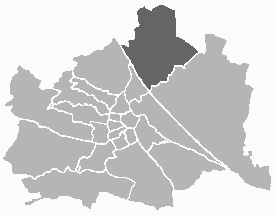
Donaustadt
- 22. district of Vienna, Austria
Hiking in Donaustadt
Donaustadt is a district in Vienna, Austria, located along the banks of the Danube River. It offers a unique combination of urban and natural landscapes, making it an attractive destination for hikers. Here are some highlights and tips for hiking in Donaustadt:...
- Country:
- Postal Code: 1220
- Licence Plate Code: W
- Coordinates: 48° 13' 5" N, 16° 28' 59" E
- GPS tracks (wikiloc): [Link]
- AboveSeaLevel: 152 м m
- Area: 102.29 sq km
- Web site: [Link]

Floridsdorf
- 21. district of Vienna
Hiking in Floridsdorf
Floridsdorf is one of the 23 districts of Vienna, Austria, and while it is primarily an urban area, there are some lovely opportunities for outdoor activities and hiking in and around the district. Here are some highlights for hiking enthusiasts:...
- Country:
- Postal Code: 1210
- Licence Plate Code: W
- Coordinates: 48° 17' 0" N, 16° 24' 44" E
- GPS tracks (wikiloc): [Link]
- AboveSeaLevel: 159 м m
- Area: 44.52 sq km
- Web site: [Link]
Brigittenau
- 20. district of Vienna
Hiking in Brigittenau
Brigittenau is a 20th district of Vienna, Austria, situated on the northern banks of the Danube Canal. While it is an urban area and not traditionally associated with hiking, it still offers some opportunities for walking and enjoying the outdoors. Here are some aspects to consider if you’re interested in hiking or walking in and around Brigittenau:...
- Country:
- Postal Code: 1200
- Licence Plate Code: W
- Coordinates: 48° 14' 12" N, 16° 22' 10" E
- GPS tracks (wikiloc): [Link]
- AboveSeaLevel: 165 м m
- Area: 5.67 sq km
- Web site: [Link]

Innere Stadt
- first district of Vienna
Hiking in Innere Stadt
Innere Stadt, the historic city center of Vienna, Austria, is not typically known for hiking in the traditional sense; however, it offers plenty of opportunities for urban exploration and walking that can be quite enjoyable and fulfilling. The area is rich in history, culture, and stunning architecture, making it an ideal destination for long strolls and leisurely walks....
- Country:
- Postal Code: 1010
- Licence Plate Code: W
- Coordinates: 48° 12' 35" N, 16° 22' 12" E
- GPS tracks (wikiloc): [Link]
- AboveSeaLevel: 192 м m
- Area: 3.01 sq km
- Web site: [Link]


Simmering
- 11. district of Vienna
Hiking in Simmering
Simmering is a district in the southeastern part of Vienna, and while it is primarily an urban area, there are some opportunities for enjoyable walks and light hiking in the vicinity. Here are some key points to consider for anyone wanting to explore hiking-like experiences in and around Simmering:...
- Country:
- Postal Code: 1110
- Licence Plate Code: W
- Coordinates: 48° 10' 12" N, 16° 27' 0" E
- GPS tracks (wikiloc): [Link]
- AboveSeaLevel: 156 м m
- Area: 23.27 sq km
- Population: 97333
- Web site: [Link]
Landstraße
- 3rd municipal District of Vienna, Austria
Hiking in Landstraße
Landstraße, located in Vienna, Austria, is not traditionally known for hiking, as it is primarily an urban district. However, there are plenty of walking and exploration opportunities in and around this area, especially for those interested in urban hikes or scenic walks....
- Country:
- Postal Code: 1030
- Licence Plate Code: W
- Coordinates: 48° 11' 47" N, 16° 23' 45" E
- GPS tracks (wikiloc): [Link]
- AboveSeaLevel: 178 м m
- Area: 7.39 sq km
- Web site: [Link]