Bruebach (Bruebach)
- commune in Haut-Rhin, France
Bruebach is a charming village located in the Haut-Rhin department of Alsace, France. It offers a range of hiking opportunities that allow you to explore the beautiful landscapes of the surrounding region, which is characterized by scenic hills, vineyards, and forests.
Popular Hiking Trails:
-
Local Trails: There are several marked local trails that cater to various skill levels. You can enjoy strolls through vineyards, alongside rivers, or into the nearby hills. Look for yellow markers which indicate hiking paths in the region.
-
Hiking to Nearby Attractions: Many hikers take advantage of Bruebach's proximity to destinations like the Vosges Mountains or the Alsace Wine Route, which are accessible for day hikes.
-
The Grand Ried Trail: This trail runs through the wetlands of the region, providing unique views of local flora and fauna, and is ideal for those interested in nature.
Key Considerations:
- Seasonal Conditions: The best time for hiking in the region is in spring and fall when temperatures are mild and landscapes are vibrant.
- Equipment: Depending on the difficulty of your chosen trail, ensure you have appropriate footwear, water, and a map or a GPS device.
- Local Guidelines: Always check local regulations regarding trail access, especially in more protected areas.
Additional Activities:
In addition to hiking, you might also enjoy cycling, wine tasting at local vineyards, or exploring the rich culture and history of the Alsace region.
Safety Tips:
- Inform someone of your hiking plans and expected return time.
- Check the weather forecast before heading out.
- Be aware of your surroundings and wildlife, respecting nature to help preserve the beauty for others.
Enjoy your hiking adventure in Bruebach! If you have any more specific questions or need trail recommendations, feel free to ask!
- Country:

- Postal Code: 68440
- Coordinates: 47° 41' 59" N, 7° 21' 35" E


- GPS tracks (wikiloc): [Link]
- Area: 7.01 sq km
- Population: 1059
- Wikipedia en: wiki(en)
- Wikipedia: wiki(fr)
- Wikidata storage: Wikidata: Q367442
- Wikipedia Commons Category: [Link]
- Freebase ID: [/m/03nss0q]
- Freebase ID: [/m/03nss0q]
- GeoNames ID: Alt: [6450673]
- GeoNames ID: Alt: [6450673]
- SIREN number: [216800557]
- SIREN number: [216800557]
- BnF ID: [15271757s]
- BnF ID: [15271757s]
- INSEE municipality code: 68055
- INSEE municipality code: 68055
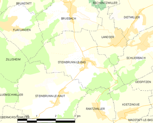
Shares border with regions:


Landser
- commune in Haut-Rhin, France
Landser, located in the Haut-Rhin department of France, is a charming town that offers a variety of hiking opportunities. Nestled in the Alsace region, near the foothills of the Vosges Mountains, Landser is surrounded by picturesque landscapes, vineyards, and forests, making it a great destination for outdoor enthusiasts....
- Country:

- Postal Code: 68440
- Coordinates: 47° 41' 6" N, 7° 23' 27" E


- GPS tracks (wikiloc): [Link]
- Area: 3.04 sq km
- Population: 1567


Riedisheim
- commune in Haut-Rhin, France
Riedisheim, located in the Alsace region of France near Mulhouse, offers access to beautiful landscapes and hiking opportunities in the surrounding areas. While Riedisheim itself is more urban, it's in proximity to several natural attractions and hiking trails....
- Country:

- Postal Code: 68400
- Coordinates: 47° 44' 54" N, 7° 22' 1" E


- GPS tracks (wikiloc): [Link]
- Area: 6.96 sq km
- Population: 12151
- Web site: [Link]


Rixheim
- commune in Haut-Rhin, France
Rixheim is a charming commune located in the Alsace region of France, near the larger city of Mulhouse. While Rixheim itself may not be a major hiking destination, its proximity to the Vosges Mountains and the scenic landscapes of Alsace offers several opportunities for hiking enthusiasts....
- Country:

- Postal Code: 68170
- Coordinates: 47° 44' 55" N, 7° 24' 16" E


- GPS tracks (wikiloc): [Link]
- Area: 19.53 sq km
- Population: 13990
- Web site: [Link]


Zimmersheim
- commune in Haut-Rhin, France
Zimmersheim is a small village located in the Alsace region of France, near the larger city of Mulhouse. While it may not be a well-known hiking destination, the surrounding area offers beautiful landscapes and opportunities for outdoor activities. Here are some insights about hiking in and around Zimmersheim:...
- Country:

- Postal Code: 68440
- Coordinates: 47° 43' 11" N, 7° 23' 17" E


- GPS tracks (wikiloc): [Link]
- Area: 3.15 sq km
- Population: 1042


Brunstatt
- former commune in Haut-Rhin, France
Brunstatt is a charming municipality located in the Alsace region of France, near the border with Germany. While it's not as widely known for hiking as some other areas, there are a few lovely opportunities for outdoor activities and exploring nature in and around Brunstatt....
- Country:

- Postal Code: 68350
- Coordinates: 47° 43' 24" N, 7° 19' 22" E


- GPS tracks (wikiloc): [Link]
- AboveSeaLevel: 284.5 м m
- Area: 9.66 sq km
- Population: 6175
- Web site: [Link]


Flaxlanden
- commune in Haut-Rhin, France
Flaxlanden is a small village located in the Grand Est region of France, near the city of Mulhouse. While it may not be as well-known as some major hiking destinations, there are still opportunities to explore the scenic countryside and nearby nature....
- Country:

- Postal Code: 68720
- Coordinates: 47° 41' 45" N, 7° 18' 55" E


- GPS tracks (wikiloc): [Link]
- Area: 4.33 sq km
- Population: 1454


Eschentzwiller
- commune in Haut-Rhin, France
Eschentzwiller is a small commune located in the Haut-Rhin department of the Grand Est Region in France, close to the border with Switzerland. While it may not be widely known for extensive hiking trails, it offers a tranquil environment for those looking to explore the scenic beauty of the region. Here are a few key points to consider about hiking in and around Eschentzwiller:...
- Country:

- Postal Code: 68440
- Coordinates: 47° 42' 46" N, 7° 23' 55" E


- GPS tracks (wikiloc): [Link]
- Area: 3.19 sq km
- Population: 1505


Steinbrunn-le-Bas
- commune in Haut-Rhin, France
Steinbrunn-le-Bas is a small village located in the Alsace region of France, near the border with Germany. This area is characterized by its scenic countryside, vineyards, and picturesque landscapes, making it a great spot for hiking enthusiasts....
- Country:

- Postal Code: 68440
- Coordinates: 47° 40' 33" N, 7° 22' 2" E


- GPS tracks (wikiloc): [Link]
- Area: 8.58 sq km
- Population: 688

