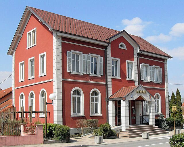
Landser (Landser)

- commune in Haut-Rhin, France
 Hiking in Landser
Landser, located in the Haut-Rhin department of France, is a charming town that offers a variety of hiking opportunities. Nestled in the Alsace region, near the foothills of the Vosges Mountains, Landser is surrounded by picturesque landscapes, vineyards, and forests, making it a great destination for outdoor enthusiasts.
Hiking Trails
-
Local Trails: There are several well-marked hiking paths in and around Landser. These trails range from easy walks to more challenging hikes, suitable for all levels of hikers.
-
Vineyard Trails: The nearby Alsatian wine route features trails that take you through beautiful vineyards. Hiking in these areas allows you to enjoy stunning views of rolling hills and picturesque villages, and you may have the chance to sample local wines.
-
Nature Reserves: The surrounding areas, such as the wetlands and forests, are great for hiking while exploring local flora and fauna. Look for trails that lead to nature reserves, where you can experience unique ecosystems.
Scenic Attractions
- Views: Many hiking trails offer panoramic views of the Vosges Mountains and the Rhine Valley, especially from higher elevations.
- Cultural Sites: Some trails might lead to historical sites, such as castles or old churches, giving you a chance to experience the cultural heritage of the region.
Tips for Hiking in Landser
- Weather Preparation: Be sure to check the local weather conditions before heading out, as they can change quickly in mountain areas.
- Proper Gear: Wear comfortable hiking shoes and bring plenty of water, snacks, a map, or a GPS device.
- Trail Etiquette: Follow marked trails and observe local wildlife guidelines to preserve the natural beauty of the area.
Local Resources
- Tourist Office: The Landser tourist office can provide maps, guides, and information about local hiking events or organized hikes.
- Hiking Groups: Consider joining a local hiking group to meet fellow hikers and explore trails you may not have discovered on your own.
Hiking in Landser allows you to immerse yourself in the stunning natural beauty of Alsace, while also enjoying a taste of the local culture. Whether you’re a beginner or an experienced hiker, there are plenty of options to make your visit enjoyable.
- Country:

- Postal Code: 68440
- Coordinates: 47° 41' 6" N, 7° 23' 27" E


- GPS tracks (wikiloc): [Link]
- Area: 3.04 sq km
- Population: 1567
- Wikipedia en: wiki(en)
- Wikipedia: wiki(fr)
- Wikidata storage: Wikidata: Q121595
- Wikipedia Commons Category: [Link]
- Freebase ID: [/m/03nst52]
- Freebase ID: [/m/03nst52]
- GeoNames ID: Alt: [6441501]
- GeoNames ID: Alt: [6441501]
- SIREN number: [216801746]
- SIREN number: [216801746]
- BnF ID: [15271876b]
- BnF ID: [15271876b]
- VIAF ID: Alt: [159251249]
- VIAF ID: Alt: [159251249]
- INSEE municipality code: 68174
- INSEE municipality code: 68174
Shares border with regions:


Bruebach
- commune in Haut-Rhin, France
Hiking in Bruebach
Bruebach is a charming village located in the Haut-Rhin department of Alsace, France. It offers a range of hiking opportunities that allow you to explore the beautiful landscapes of the surrounding region, which is characterized by scenic hills, vineyards, and forests....
- Country:
- Postal Code: 68440
- Coordinates: 47° 41' 59" N, 7° 21' 35" E
- GPS tracks (wikiloc): [Link]
- Area: 7.01 sq km
- Population: 1059

Dietwiller
- commune in Haut-Rhin, France
Hiking in Dietwiller
Dietwiller is a small commune located in the Alsace region of France, near Mulhouse. While it may not be widely known as a hiking destination, there are several opportunities to enjoy nature and explore the local landscape. Here are some points to consider if you're planning a hike in and around Dietwiller:...
- Country:
- Postal Code: 68440
- Coordinates: 47° 41' 29" N, 7° 24' 5" E
- GPS tracks (wikiloc): [Link]
- Area: 11.06 sq km
- Population: 1442
- Web site: [Link]


Eschentzwiller
- commune in Haut-Rhin, France
Hiking in Eschentzwiller
Eschentzwiller is a small commune located in the Haut-Rhin department of the Grand Est Region in France, close to the border with Switzerland. While it may not be widely known for extensive hiking trails, it offers a tranquil environment for those looking to explore the scenic beauty of the region. Here are a few key points to consider about hiking in and around Eschentzwiller:...
- Country:
- Postal Code: 68440
- Coordinates: 47° 42' 46" N, 7° 23' 55" E
- GPS tracks (wikiloc): [Link]
- Area: 3.19 sq km
- Population: 1505

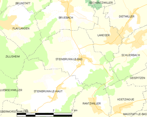
Steinbrunn-le-Bas
- commune in Haut-Rhin, France
Hiking in Steinbrunn-le-Bas
Steinbrunn-le-Bas is a small village located in the Alsace region of France, near the border with Germany. This area is characterized by its scenic countryside, vineyards, and picturesque landscapes, making it a great spot for hiking enthusiasts....
- Country:
- Postal Code: 68440
- Coordinates: 47° 40' 33" N, 7° 22' 2" E
- GPS tracks (wikiloc): [Link]
- Area: 8.58 sq km
- Population: 688

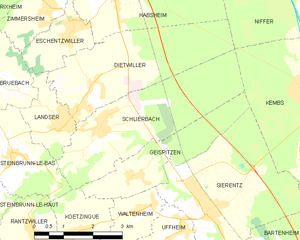
Schlierbach
- commune in Haut-Rhin, France
Hiking in Schlierbach
Schlierbach, located in the Haut-Rhin department in the Alsace region of France, offers beautiful landscapes and a variety of hiking opportunities. Here are some key points about hiking in this charming area:...
- Country:
- Postal Code: 68440
- Coordinates: 47° 40' 58" N, 7° 24' 30" E
- GPS tracks (wikiloc): [Link]
- Area: 11.8 sq km
- Population: 1205