
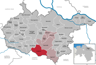
Buchholz in der Nordheide (Buchholz in der Nordheide)

- town in the district of Harburg, in Lower Saxony, Germany
 Hiking in Buchholz in der Nordheide
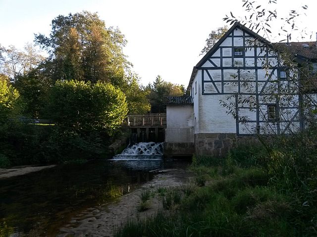
Buchholz in der Nordheide, located in Lower Saxony, Germany, is surrounded by picturesque landscapes that offer excellent opportunities for hiking. While it may not be as well-known as some of Germany's larger hiking destinations, it has several trails and natural areas that can be quite appealing for outdoor enthusiasts.
Hiking Trails and Areas
-
Nordheide Trail: The region is part of the Nordheide area, which features various trails that wind through forests, heathlands, and meadows. The trails vary in difficulty and distance, making it suitable for both beginners and seasoned hikers.
-
Lüneburger Heide National Park: While not directly in Buchholz, it's close enough for day trips. This national park offers numerous well-marked trails through stunning heath landscapes, particularly vibrant when heather is in bloom.
-
Local Parks and Forests: Within and around Buchholz, there are several parks and forests where you can enjoy shorter walks. The town is surrounded by nature, offering easy access to leafy paths and scenic views.
Tips for Hiking in Buchholz
- Weather: Always check the weather before heading out, as conditions can change quickly.
- Maps and Guides: Utilize local maps or hiking apps to navigate through the trails, as some may not be well-marked.
- Water and Snacks: Bring enough water and energy-boosting snacks, especially if you plan to hike for several hours.
- Footwear: Wear comfortable and appropriate hiking shoes to avoid blisters and strain.
Additional Activities
In addition to hiking, Buchholz in der Nordheide offers options for biking and nature photography, as the surrounding area is quite scenic. The town itself has a charming atmosphere with local shops and cafes where you can relax after a hike.
Conclusion
Buchholz in der Nordheide is a great starting point for exploring the natural beauty of Lower Saxony. Whether you prefer short leisurely walks or longer hikes through varied terrain, this area has something to offer for everyone!
- Country:

- Postal Code: 21244
- Local Dialing Code: 04181
- Licence Plate Code: WL
- Coordinates: 53° 19' 43" N, 9° 51' 43" E


- GPS tracks (wikiloc): [Link]
- AboveSeaLevel: 55 м m
- Area: 74.62 sq km
- Population: 38689
- Web site: https://www.buchholz.de/
- Wikipedia en: wiki(en)
- Wikipedia: wiki(de)
- Wikidata storage: Wikidata: Q14892
- Wikipedia Commons Category: [Link]
- Freebase ID: [/m/0c721f]
- Freebase ID: [/m/0c721f]
- GeoNames ID: Alt: [6557437]
- GeoNames ID: Alt: [6557437]
- BnF ID: [151726985]
- BnF ID: [151726985]
- VIAF ID: Alt: [151302734]
- VIAF ID: Alt: [151302734]
- OSM relation ID: [111406]
- OSM relation ID: [111406]
- GND ID: Alt: [4008644-6]
- GND ID: Alt: [4008644-6]
- Library of Congress authority ID: Alt: [n82274107]
- Library of Congress authority ID: Alt: [n82274107]
- MusicBrainz area ID: [ba9cf04c-c8c4-43ee-87fb-a334a0cdb671]
- MusicBrainz area ID: [ba9cf04c-c8c4-43ee-87fb-a334a0cdb671]
- WOEID: [642123]
- WOEID: [642123]
- Quora topic ID: [Buchholz-in-Der-Nordheide]
- Quora topic ID: [Buchholz-in-Der-Nordheide]
- DMOZ ID: Alt: [Regional/Europe/Germany/States/Lower_Saxony/Localities/Buchholz_in_der_Nordheide/]
- DMOZ ID: Alt: [Regional/Europe/Germany/States/Lower_Saxony/Localities/Buchholz_in_der_Nordheide/]
- German municipality key: 03353005
- German municipality key: 03353005
Includes regions:
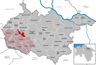
Dibbersen
- human settlement in Germany
Hiking in Dibbersen
Dibbersen is a charming area located near Buchholz in der Nordheide, Germany. While it may not be as widely known as some of the larger national parks or hiking trails in the country, it does offer some beautiful opportunities for hiking and enjoying nature....
- Country:
- Postal Code: 21244
- Local Dialing Code: 04181
- Coordinates: 53° 21' 59" N, 9° 52' 29" E
- GPS tracks (wikiloc): [Link]
- AboveSeaLevel: 98 м m

Holm-Seppensen
- human settlement
Hiking in Holm-Seppensen
Holm-Seppensen is a small village located in Lower Saxony, Germany, within the municipality of Buchholz in der Nordheide. The area is characterized by its scenic landscapes, forests, and proximity to natural reserves, making it a great spot for hiking and outdoor activities....
- Country:
- Postal Code: 21244
- Local Dialing Code: 04187
- Coordinates: 53° 17' 9" N, 9° 52' 16" E
- GPS tracks (wikiloc): [Link]
Sprötze
- human settlement
Hiking in Sprötze
Sprötze is a charming area located in Lower Saxony, Germany, known for its scenic landscapes and natural beauty. While not as widely recognized as some larger hiking destinations, it offers a variety of trails suitable for different skill levels....
- Country:
- Postal Code: 21244
- Local Dialing Code: 04186
- Coordinates: 53° 18' 34" N, 9° 48' 22" E
- GPS tracks (wikiloc): [Link]
- AboveSeaLevel: 60 м m
Reindorf
- human settlement in Germany
Hiking in Reindorf
Reindorf, located in Austria, is surrounded by beautiful landscapes that offer excellent opportunities for hiking enthusiasts. The region features a mix of scenic views, rich flora and fauna, and well-marked trails suitable for various skill levels....
- Country:
- Postal Code: 21244
- Coordinates: 53° 18' 50" N, 9° 54' 19" E
- GPS tracks (wikiloc): [Link]
Steinbeck
Hiking in Steinbeck
Hiking in Steinbeck, which is part of Buchholz in der Nordheide, can be a delightful experience, particularly for those looking to enjoy the natural beauty of Lower Saxony, Germany. Here are a few details about hiking in this area:...
- Country:
- Postal Code: 21244
- Local Dialing Code: 04181
- Coordinates: 53° 20' 35" N, 9° 51' 2" E
- GPS tracks (wikiloc): [Link]
Trelde
- human settlement in Germany
Hiking in Trelde
Trelde is a lovely area located in Denmark, known for its scenic landscapes and outdoor activities. While it may not be as widely recognized as some other hiking destinations, it offers beautiful trails that are great for both casual walkers and experienced hikers....
- Country:
- Postal Code: 21244
- Local Dialing Code: 04186
- Coordinates: 53° 19' 7" N, 9° 47' 38" E
- GPS tracks (wikiloc): [Link]
- AboveSeaLevel: 51 м m
Shares border with regions:


Wenzendorf
- municipality of Germany
Hiking in Wenzendorf
Wenzendorf, a small village located in Lower Saxony, Germany, offers a serene environment for hiking enthusiasts. While the village itself may not be a well-known hiking destination, its surrounding landscapes and trails provide plenty of opportunities for those looking to explore nature....
- Country:
- Postal Code: 21279
- Local Dialing Code: 04165
- Licence Plate Code: WL
- Coordinates: 53° 21' 0" N, 9° 46' 0" E
- GPS tracks (wikiloc): [Link]
- AboveSeaLevel: 64 м m
- Area: 21.47 sq km
- Population: 1434
- Web site: [Link]


Rosengarten
- rural municipality in the district of Harburg, Lower Saxony, Germany
Hiking in Rosengarten
Rosengarten, located in Lower Saxony, Germany, offers hikers a beautiful landscape characterized by its rolling hills, dense forests, and scenic views. The area is part of the Lüneburg Heath, known for its unique heathland ecosystems and diverse flora and fauna....
- Country:
- Postal Code: 21224
- Local Dialing Code: 04108; 04105; 040
- Licence Plate Code: WL
- Coordinates: 53° 23' 0" N, 9° 54' 0" E
- GPS tracks (wikiloc): [Link]
- AboveSeaLevel: 85 м m
- Area: 63.67 sq km
- Population: 14031
- Web site: [Link]


Neu Wulmstorf
- German municipality in Lower Saxony
Hiking in Neu Wulmstorf
Neu Wulmstorf is located in Lower Saxony, Germany, and while it may not be a major hiking destination like some national parks, it does offer some pleasant outdoor experiences for those looking to enjoy nature and hiking....
- Country:
- Postal Code: 21629
- Local Dialing Code: 04168; 040
- Licence Plate Code: WL
- Coordinates: 53° 25' 22" N, 9° 47' 23" E
- GPS tracks (wikiloc): [Link]
- AboveSeaLevel: 49 м m
- Area: 56.16 sq km
- Population: 21159
- Web site: [Link]

Undeloh
- municipality of Germany
Hiking in Undeloh
Undeloh is a charming village located in the Lüneburg Heath (Lüneburger Heide) region of Lower Saxony, Germany. This area is known for its stunning natural beauty, characterized by heather fields, forests, and picturesque landscapes, making it an excellent destination for hiking enthusiasts....
- Country:
- Postal Code: 29640; 21274
- Local Dialing Code: 04189
- Licence Plate Code: WL
- Coordinates: 53° 11' 50" N, 9° 58' 33" E
- GPS tracks (wikiloc): [Link]
- AboveSeaLevel: 85 м m
- Area: 48.2 sq km
- Population: 987
- Web site: [Link]
Drestedt
- municipality of Germany
Hiking in Drestedt
Drestedt is a small town located in Lower Saxony, Germany. While it may not be widely known for extensive hiking trails, its proximity to scenic areas and regional parks offers some opportunities for outdoor enthusiasts. Here’s what you need to know about hiking around Drestedt:...
- Country:
- Postal Code: 21279
- Local Dialing Code: 04186
- Licence Plate Code: WL
- Coordinates: 53° 20' 0" N, 9° 46' 0" E
- GPS tracks (wikiloc): [Link]
- AboveSeaLevel: 48 м m
- Area: 5.71 sq km
- Population: 768
- Web site: [Link]
Kakenstorf
- municipality of Germany
Hiking in Kakenstorf
Kakenstorf is a small village in Lower Saxony, Germany, located near the larger city of Hamburg. While it may not be a prominent hiking destination, there are several opportunities for nature walks and hikes in the surrounding areas, particularly in the Lüneburg Heath (Lüneburger Heide) region, which is accessible from Kakenstorf....
- Country:
- Postal Code: 21255
- Local Dialing Code: 04186
- Licence Plate Code: WL
- Coordinates: 53° 19' 0" N, 9° 46' 0" E
- GPS tracks (wikiloc): [Link]
- AboveSeaLevel: 46 м m
- Area: 38.71 sq km
- Population: 1393
- Web site: [Link]


Jesteburg
- municipality of Germany
Hiking in Jesteburg
Jesteburg, a charming village in Lower Saxony, Germany, offers a delightful setting for hiking enthusiasts. Surrounded by lush forests, picturesque fields, and scenic landscapes, it provides several hiking trails suitable for various skill levels....
- Country:
- Postal Code: 21266
- Local Dialing Code: 04183; 04181
- Licence Plate Code: WL
- Coordinates: 53° 18' 0" N, 9° 58' 0" E
- GPS tracks (wikiloc): [Link]
- AboveSeaLevel: 41 м m
- Area: 27.97 sq km
- Population: 7966
- Web site: [Link]


Tostedt
- municipality of Germany
Hiking in Tostedt
Tostedt is a small town located in Lower Saxony, Germany, and while it might not be as well-known for hiking as some of the larger parks or regions, it offers some lovely opportunities for outdoor enthusiasts. Here are some details about hiking in and around Tostedt:...
- Country:
- Postal Code: 21255
- Local Dialing Code: 04182
- Licence Plate Code: WL
- Coordinates: 53° 17' 0" N, 9° 43' 0" E
- GPS tracks (wikiloc): [Link]
- AboveSeaLevel: 61 м m
- Area: 48.24 sq km
- Population: 13895
- Web site: [Link]


Hanstedt
- municipality of Germany
Hiking in Hanstedt
Hanstedt, located in Lower Saxony, Germany, is an area surrounded by picturesque landscapes and offers several opportunities for hiking enthusiasts. The surrounding region includes lush forests, charming villages, and scenic farmland, making it ideal for both short walks and more extended hikes. Here are some key points about hiking in Hanstedt:...
- Country:
- Postal Code: 21271
- Local Dialing Code: 04184
- Licence Plate Code: WL
- Coordinates: 53° 16' 0" N, 10° 1' 0" E
- GPS tracks (wikiloc): [Link]
- AboveSeaLevel: 45 м m
- Area: 59.3 sq km
- Population: 5595
- Web site: [Link]


Handeloh
- municipality of Germany
Hiking in Handeloh
Handeloh is a charming village located in Lower Saxony, Germany, and it offers a variety of hiking opportunities for outdoor enthusiasts. While not as widely known as some larger hiking destinations, the area is characterized by its beautiful landscapes, woodlands, and serene countryside, making it an appealing spot for local hikes....
- Country:
- Postal Code: 21256
- Local Dialing Code: 04188
- Licence Plate Code: WL
- Coordinates: 53° 14' 44" N, 9° 50' 21" E
- GPS tracks (wikiloc): [Link]
- AboveSeaLevel: 56 м m
- Area: 26.91 sq km
- Population: 2488
- Web site: [Link]