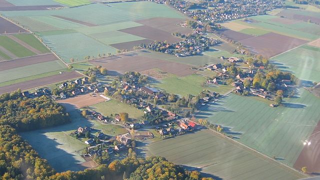
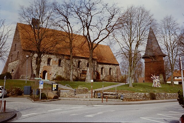
Rosengarten (Rosengarten)

- rural municipality in the district of Harburg, Lower Saxony, Germany
 Hiking in Rosengarten
Rosengarten, located in Lower Saxony, Germany, offers hikers a beautiful landscape characterized by its rolling hills, dense forests, and scenic views. The area is part of the Lüneburg Heath, known for its unique heathland ecosystems and diverse flora and fauna.
Hiking Trails:
-
Heath Trails: The region features several well-marked trails that vary in length and difficulty. Many of these trails allow you to explore the picturesque heathlands, particularly stunning during the blooming season in late summer when the heaths are covered in purple flowers.
-
Forest Trails: There are numerous routes winding through the lush forests, providing opportunities for shaded walks and the chance to see local wildlife such as deer and a variety of birds.
-
Panoramic Views: Some trails lead to elevated viewpoints that offer breathtaking vistas of the surrounding countryside. Be sure to check local maps or guides for the best viewpoints.
Tips for Hiking in Rosengarten:
- Gear: Wear sturdy, comfortable hiking boots and dress in layers to accommodate changing weather conditions. A good backpack with water, snacks, and a first-aid kit is essential.
- Navigation: While trails are generally well-marked, it's a good idea to carry a map or download a hiking app for navigation, especially if you plan to explore less well-known routes.
- Respect Nature: Follow the “Leave No Trace” principles. Stay on marked paths, take your trash with you, and be respectful of wildlife.
- Local Weather: Always check the weather forecast before heading out, as conditions can change quickly in the region.
Accessibility:
Rosengarten is easily accessible from nearby cities, making it an excellent day-trip destination for both locals and visitors. You can often find parking near trailheads or access points.
Recommendations:
Consider visiting local information centers or tourism offices for updated trail maps and information about any seasonal events or guided hikes. The local culture, cuisine, and hospitality also enhance the hiking experience, so don’t miss out on trying regional dishes after your outdoor adventure.
Whether you’re a novice or an experienced hiker, Rosengarten offers a wonderful opportunity to immerse yourself in nature and enjoy the beautiful landscapes of Lower Saxony!
- Country:

- Postal Code: 21224
- Local Dialing Code: 04108; 04105; 040
- Licence Plate Code: WL
- Coordinates: 53° 23' 0" N, 9° 54' 0" E


- GPS tracks (wikiloc): [Link]
- AboveSeaLevel: 85 м m
- Area: 63.67 sq km
- Population: 14031
- Web site: https://www.gemeinde-rosengarten.de/
- Wikipedia en: wiki(en)
- Wikipedia: wiki(de)
- Wikidata storage: Wikidata: Q501683
- Wikipedia Commons Category: [Link]
- Freebase ID: [/m/09_g6g]
- Freebase ID: [/m/09_g6g]
- GeoNames ID: Alt: [2845012]
- GeoNames ID: Alt: [2845012]
- VIAF ID: Alt: [152467260]
- VIAF ID: Alt: [152467260]
- OSM relation ID: [68669]
- OSM relation ID: [68669]
- GND ID: Alt: [4050552-2]
- GND ID: Alt: [4050552-2]
- archINFORM location ID: [44060]
- archINFORM location ID: [44060]
- MusicBrainz area ID: [f66a2ba7-60c5-4980-8d02-76104adcf241]
- MusicBrainz area ID: [f66a2ba7-60c5-4980-8d02-76104adcf241]
- German municipality key: 03353029
- German municipality key: 03353029
Includes regions:
Ehestorf
- Village in the Municipality for Rosengarten, Lower Saxony
Hiking in Ehestorf
Ehestorf is a charming village located within the Rosengarten municipality in Lower Saxony, Germany. Surrounded by picturesque landscapes and lush greenery, it offers a variety of hiking opportunities for both beginners and experienced hikers....
- Country:
- Postal Code: 21224
- Coordinates: 53° 26' 36" N, 9° 54' 8" E
- GPS tracks (wikiloc): [Link]
- AboveSeaLevel: 87 м m
Sottorf
- village in Rosengarten, Lower Saxony
Hiking in Sottorf
Sottorf, located in the municipality of Rosengarten in Lower Saxony, Germany, offers a variety of hiking opportunities that provide a delightful experience of the natural surroundings. The area is characterized by its picturesque landscapes, which include forests, fields, and wetlands....
- Country:
- Postal Code: 21224
- Local Dialing Code: 04108
- Coordinates: 53° 25' 18" N, 9° 53' 50" E
- GPS tracks (wikiloc): [Link]
- AboveSeaLevel: 99 м m
Klecken
- Village in the Municipality for Rosengarten, Lower Saxony
Hiking in Klecken
Klecken is a small village located in Lower Saxony, Germany, not far from Hamburg. While it may not be widely known as a hiking destination, there are still opportunities for outdoor enthusiasts to enjoy the natural beauty of the area....
- Country:
- Postal Code: 21224
- Local Dialing Code: 04105
- Coordinates: 53° 22' 1" N, 9° 56' 21" E
- GPS tracks (wikiloc): [Link]
- AboveSeaLevel: 81 м m
Iddensen
- Village in the Municipality for Rosengarten, Lower Saxony
Hiking in Iddensen
Iddensen is a small village in the region of Lower Saxony, Germany, surrounded by scenic landscapes that make it a great spot for hiking enthusiasts. While specific trails in Iddensen may not be widely recognized, you can explore a variety of hiking options in the surrounding areas. Here are some tips and highlights for hiking near Iddensen:...
- Country:
- Postal Code: 21224
- Local Dialing Code: 04108
- Coordinates: 53° 23' 0" N, 9° 54' 0" E
- GPS tracks (wikiloc): [Link]
- AboveSeaLevel: 88 м m

Emsen
- human settlement in Germany
Hiking in Emsen
Emsen, located in the Rosengarten district of Germany, is known for its picturesque hiking trails and natural beauty, making it a lovely destination for outdoor enthusiasts. The Rosengarten area, primarily recognized for its gardens and scenic landscapes, also offers trails that cater to hikers of all experience levels....
- Country:
- Postal Code: 21224
- Local Dialing Code: 04108
- Coordinates: 53° 22' 59" N, 9° 51' 44" E
- GPS tracks (wikiloc): [Link]
- AboveSeaLevel: 123 м m
Nenndorf
Hiking in Nenndorf
Nenndorf is a small town located in Lower Saxony, Germany, and offers a peaceful setting for hiking enthusiasts. While it's not widely known as a major hiking destination, there are some lovely areas to explore nearby....
- Country:
- Postal Code: 21224
- Coordinates: 53° 22' 44" N, 9° 53' 32" E
- GPS tracks (wikiloc): [Link]
Eckel
- human settlement in Germany
Hiking in Eckel
Eckel, often associated with the Rosengarten area, is known for its stunning alpine scenery and diverse hiking trails. Here are some highlights and tips for hiking in this region:...
- Country:
- Postal Code: 21224
- Local Dialing Code: 04105
- Coordinates: 53° 22' 3" N, 9° 54' 57" E
- GPS tracks (wikiloc): [Link]
- AboveSeaLevel: 86 м m
Leversen
- human settlement in Germany
Hiking in Leversen
Leversen is a small village located in Germany, specifically in the Lower Saxony region. While it may not be as widely known as other hiking destinations, the surrounding area offers lovely landscapes and trails for those looking to explore nature....
- Country:
Vahrendorf
- Village in the Municipality for Rosengarten, Lower Saxony
Hiking in Vahrendorf
Vahrendorf, a small village in northern Germany, near Hamburg, offers a unique hiking experience. The area is characterized by picturesque landscapes, including forests, meadows, and scenic trails that are suitable for various skill levels....
- Country:
- Postal Code: 21224
- Local Dialing Code: 04108
- Coordinates: 53° 25' 57" N, 9° 54' 20" E
- GPS tracks (wikiloc): [Link]
- AboveSeaLevel: 95 м m
Tötensen
- village in Germany
Hiking in Tötensen
Tötensen is a small village located in Lower Saxony, Germany, and while it may not be widely known for extensive hiking trails, it does offer a peaceful environment that can be appealing for outdoor enthusiasts. Here are some points to consider if you're planning a hike in or near Tötensen:...
- Country:
- Postal Code: 21224
- Local Dialing Code: 04108
- Coordinates: 53° 24' 0" N, 9° 56' 0" E
- GPS tracks (wikiloc): [Link]
Shares border with regions:


Hamburg
- city in Germany, city state and federal state
Hiking in Hamburg
Hiking in and around Hamburg offers a unique blend of urban landscapes and natural scenery. While Hamburg is primarily known for its rich maritime history and vibrant city life, nearby areas provide some excellent opportunities for hiking enthusiasts....
- Country:
- Postal Code: 22041–22769; 20095–21149
- Local Dialing Code: 04721; 040
- Licence Plate Code: HH
- Coordinates: 53° 33' 0" N, 10° 0' 0" E
- GPS tracks (wikiloc): [Link]
- AboveSeaLevel: 6 м m
- Area: 755.30 sq km
- Population: 1834244
- Web site: [Link]


Buchholz in der Nordheide
- town in the district of Harburg, in Lower Saxony, Germany
Hiking in Buchholz in der Nordheide
Buchholz in der Nordheide, located in Lower Saxony, Germany, is surrounded by picturesque landscapes that offer excellent opportunities for hiking. While it may not be as well-known as some of Germany's larger hiking destinations, it has several trails and natural areas that can be quite appealing for outdoor enthusiasts....
- Country:
- Postal Code: 21244
- Local Dialing Code: 04181
- Licence Plate Code: WL
- Coordinates: 53° 19' 43" N, 9° 51' 43" E
- GPS tracks (wikiloc): [Link]
- AboveSeaLevel: 55 м m
- Area: 74.62 sq km
- Population: 38689
- Web site: [Link]


Neu Wulmstorf
- German municipality in Lower Saxony
Hiking in Neu Wulmstorf
Neu Wulmstorf is located in Lower Saxony, Germany, and while it may not be a major hiking destination like some national parks, it does offer some pleasant outdoor experiences for those looking to enjoy nature and hiking....
- Country:
- Postal Code: 21629
- Local Dialing Code: 04168; 040
- Licence Plate Code: WL
- Coordinates: 53° 25' 22" N, 9° 47' 23" E
- GPS tracks (wikiloc): [Link]
- AboveSeaLevel: 49 м m
- Area: 56.16 sq km
- Population: 21159
- Web site: [Link]
Harmstorf
- municipality of Germany
Hiking in Harmstorf
Harmstorf is a small village located in Lower Saxony, Germany, and while it may not be widely known for hiking trails, it offers access to the beautiful landscapes typical of the surrounding areas. Here are some aspects to consider if you're planning to hike in and around Harmstorf:...
- Country:
- Postal Code: 21228
- Local Dialing Code: 04105
- Licence Plate Code: WL
- Coordinates: 53° 21' 0" N, 9° 58' 59" E
- GPS tracks (wikiloc): [Link]
- AboveSeaLevel: 15 м m
- Area: 5.97 sq km
- Population: 829
- Web site: [Link]


Jesteburg
- municipality of Germany
Hiking in Jesteburg
Jesteburg, a charming village in Lower Saxony, Germany, offers a delightful setting for hiking enthusiasts. Surrounded by lush forests, picturesque fields, and scenic landscapes, it provides several hiking trails suitable for various skill levels....
- Country:
- Postal Code: 21266
- Local Dialing Code: 04183; 04181
- Licence Plate Code: WL
- Coordinates: 53° 18' 0" N, 9° 58' 0" E
- GPS tracks (wikiloc): [Link]
- AboveSeaLevel: 41 м m
- Area: 27.97 sq km
- Population: 7966
- Web site: [Link]

Seevetal
- municipality in the district of Harburg, in Lower Saxony, Germany
Hiking in Seevetal
Seevetal, located in Lower Saxony, Germany, is not only a charming area with beautiful landscapes but also offers some wonderful hiking opportunities. The region is characterized by its lush forests, picturesque rivers, and scenic countryside. Here are some highlights and tips for hiking in Seevetal:...
- Country:
- Postal Code: 21217–21220
- Local Dialing Code: 040; 04185; 04105
- Licence Plate Code: WL
- Coordinates: 53° 23' 0" N, 10° 2' 0" E
- GPS tracks (wikiloc): [Link]
- AboveSeaLevel: 14 м m
- Area: 105.10 sq km
- Population: 41234
- Web site: [Link]