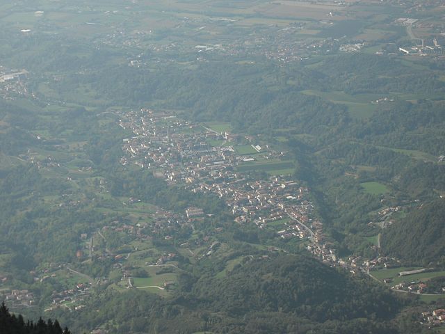
Caneva (Caneva)
.svg)
- Italian comune
 Hiking in Caneva
Caneva is a charming town located in the Province of Treviso in northern Italy, not far from the picturesque landscape of the Friuli Venezia Giulia region. The area is known for its beautiful countryside, vineyards, and proximity to the foothills of the Alps. While Caneva itself may not be as famous for hiking as some other locations, there are still several hiking opportunities in and around this region.
Hiking in and Around Caneva
-
Local Trails:
- Caneva offers access to several local trails that wind through vineyards, farmlands, and scenic countryside. These trails can vary in difficulty and length, making them suitable for beginners and experienced hikers alike.
-
Monte Cesarolo:
- A popular hiking destination near Caneva. The hike to Monte Cesarolo provides stunning panoramic views of the surrounding valleys and mountains. The trail is well-marked and typically takes a few hours to complete.
-
Natural Parks:
- Nearby, you can explore regional natural parks, such as the Parco Naturale Regionale delle Dolomiti Friulane, which features a wide variety of trails that showcase the area's unique flora and fauna. These trails can be more challenging, offering a great opportunity for seasoned hikers.
-
Proximity to Larger Hikes:
- Caneva is also a short distance from larger hiking regions, such as the Dolomites, where you can find extensive networks of hiking trails of varying difficulty. The Dolomiti National Park offers breathtaking scenery and well-established trails.
Tips for Hiking in Caneva
- Check Weather Conditions: Northern Italy can have varied weather; be sure to check forecasts before heading out.
- Footwear: Wear sturdy hiking boots, especially when tackling more rugged trails.
- Stay Hydrated: Carry enough water, especially for longer hikes.
- Respect Nature: Follow Leave No Trace principles and respect local wildlife.
Conclusion
Hiking in the Caneva area provides an opportunity to immerse yourself in Italy's beautiful natural landscapes. Whether you're strolling through vineyards or taking on more challenging mountain hikes, you'll find plenty to explore. Remember to plan ahead and enjoy the stunning scenery of this lovely region!
- Country:

- Postal Code: 33070
- Local Dialing Code: 0434
- Licence Plate Code: PN
- Coordinates: 45° 58' 0" N, 12° 27' 0" E


- GPS tracks (wikiloc): [Link]
- AboveSeaLevel: 57 м m
- Area: 41.79 sq km
- Population: 6339
- Web site: http://www.comune.caneva.pn.it
- Wikipedia en: wiki(en)
- Wikipedia: wiki(it)
- Wikidata storage: Wikidata: Q53156
- Wikipedia Commons Category: [Link]
- Freebase ID: [/m/0gqz2m]
- GeoNames ID: Alt: [6539663]
- VIAF ID: Alt: [243863456]
- OSM relation ID: [79074]
- archINFORM location ID: [45330]
- UN/LOCODE: [ITZGG]
- ISTAT ID: 093009
- Italian cadastre code: B598
Shares border with regions:
Tambre
- Italian comune
Hiking in Tambre
Tambre, located in the Veneto region of Italy, is renowned for its stunning landscapes and outdoor activities, especially hiking. The hills and mountains in and around Tambre provide a variety of trails suitable for different skill levels, from leisurely walks to more challenging treks....
- Country:
- Postal Code: 32010
- Local Dialing Code: 0437
- Licence Plate Code: BL
- Coordinates: 46° 8' 0" N, 12° 25' 0" E
- GPS tracks (wikiloc): [Link]
- AboveSeaLevel: 922 м m
- Area: 45.27 sq km
- Population: 1366
- Web site: [Link]

Fregona
- Italian comune
Hiking in Fregona
Fregona, a charming village located in the Treviso region of Italy, offers several opportunities for hikers and outdoor enthusiasts. Nestled within the foothills of the Prealps, it's surrounded by beautiful landscapes, scenic trails, and historical sites....
- Country:
- Postal Code: 31010
- Local Dialing Code: 0438
- Licence Plate Code: TV
- Coordinates: 46° 0' 29" N, 12° 20' 19" E
- GPS tracks (wikiloc): [Link]
- AboveSeaLevel: 251 м m
- Area: 42.72 sq km
- Population: 2970
- Web site: [Link]


Sarmede
- Italian comune
Hiking in Sarmede
Sarmede, a charming village located in the province of Treviso in the Veneto region of Italy, offers some wonderful opportunities for hiking. Surrounded by the picturesque landscapes of the Valdobbiadene hills and the nearby Prealps, Sarmede is an ideal spot for nature lovers and hikers of all skill levels....
- Country:
- Postal Code: 31026
- Local Dialing Code: 0438
- Licence Plate Code: TV
- Coordinates: 45° 58' 39" N, 12° 23' 7" E
- GPS tracks (wikiloc): [Link]
- AboveSeaLevel: 103 м m
- Area: 18.01 sq km
- Population: 3061
- Web site: [Link]


Cordignano
- Italian comune
Hiking in Cordignano
Cordignano is a small municipality located in the province of Treviso, in the Veneto region of Italy. It is known for its picturesque landscapes, rolling hills, and a variety of outdoor activities, making it a great spot for hiking enthusiasts....
- Country:
- Postal Code: 31016
- Local Dialing Code: 0438
- Licence Plate Code: TV
- Coordinates: 45° 57' 0" N, 12° 25' 0" E
- GPS tracks (wikiloc): [Link]
- AboveSeaLevel: 56 м m
- Area: 26.25 sq km
- Population: 7024
- Web site: [Link]


Fontanafredda
- Italian comune
Hiking in Fontanafredda
Fontanafredda, located in the Friuli-Venezia Giulia region of northern Italy, offers a beautiful hiking experience surrounded by stunning landscapes, mountains, and diverse flora and fauna. It’s part of the broader area that includes the Julian Alps and is known for its picturesque scenery, charming villages, and well-maintained trails....
- Country:
- Postal Code: 33074
- Local Dialing Code: 0434
- Licence Plate Code: PN
- Coordinates: 45° 58' 0" N, 12° 34' 0" E
- GPS tracks (wikiloc): [Link]
- AboveSeaLevel: 52 м m
- Area: 46.4 sq km
- Population: 12521
- Web site: [Link]


Polcenigo
- Italian comune
Hiking in Polcenigo
Polcenigo is a charming village located in the Friuli Venezia Giulia region of Italy, known for its beautiful landscapes and varied hiking options. The area features rolling hills, lush greenery, and scenic views of the surrounding countryside, making it a great choice for outdoor enthusiasts....
- Country:
- Postal Code: 33070
- Local Dialing Code: 0434
- Licence Plate Code: PN
- Coordinates: 46° 2' 0" N, 12° 30' 0" E
- GPS tracks (wikiloc): [Link]
- AboveSeaLevel: 42 м m
- Area: 49.69 sq km
- Population: 3151
- Web site: [Link]
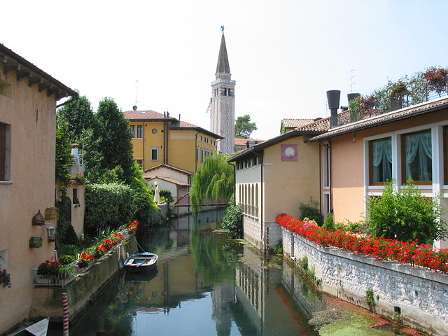
Sacile
- Italian comune
Hiking in Sacile
Sacile, located in the Friuli Venezia Giulia region of northern Italy, is a charming town surrounded by beautiful landscapes, making it a great destination for hiking enthusiasts. The area features lush hills, rivers, and stunning views of the surrounding mountains, including the nearby Dolomites. Here are some key points to consider when planning a hiking trip in Sacile:...
- Country:
- Postal Code: 33077
- Local Dialing Code: 0434
- Licence Plate Code: PN
- Coordinates: 45° 57' 15" N, 12° 30' 10" E
- GPS tracks (wikiloc): [Link]
- AboveSeaLevel: 25 м m
- Area: 32.74 sq km
- Population: 19905
- Web site: [Link]