canton of Alès-Ouest (canton d'Alès-Ouest)
- canton of France
- Country:

- Capital: Alès
- Coordinates: 44° 7' 41" N, 4° 4' 54" E


- GPS tracks (wikiloc): [Link]
- Wikidata storage: Wikidata: Q1724106
- INSEE canton code: [3003]
Includes regions:

Saint-Paul-la-Coste
- commune in Gard, France
- Country:
- Postal Code: 30480
- Coordinates: 44° 8' 59" N, 3° 58' 10" E
- GPS tracks (wikiloc): [Link]
- AboveSeaLevel: 650 м m
- Area: 18.95 sq km
- Population: 287

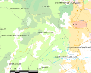
Saint-Jean-du-Pin
- commune in Gard, France
- Country:
- Postal Code: 30140
- Coordinates: 44° 7' 0" N, 4° 3' 2" E
- GPS tracks (wikiloc): [Link]
- AboveSeaLevel: 200 м m
- Area: 13.96 sq km
- Population: 1509
- Web site: [Link]
Soustelle
- commune in Gard, France
- Country:
- Postal Code: 30110
- Coordinates: 44° 10' 30" N, 4° 0' 41" E
- GPS tracks (wikiloc): [Link]
- AboveSeaLevel: 406 м m
- Area: 11.09 sq km
- Population: 131


Cendras
- commune in Gard, France
- Country:
- Postal Code: 30480
- Coordinates: 44° 9' 19" N, 4° 3' 13" E
- GPS tracks (wikiloc): [Link]
- AboveSeaLevel: 140 м m
- Area: 12.86 sq km
- Population: 1856
- Web site: [Link]


Saint-Christol-lès-Alès
- commune in Gard, France
- Country:
- Postal Code: 30380
- Coordinates: 44° 5' 4" N, 4° 4' 37" E
- GPS tracks (wikiloc): [Link]
- AboveSeaLevel: 134 м m
- Area: 20.25 sq km
- Population: 6978
- Web site: [Link]