canton of Bourgoin-Jallieu-Nord (canton de Bourgoin-Jallieu-Nord)
- canton of France
 Hiking in canton of Bourgoin-Jallieu-Nord
Canton de Bourgoin-Jallieu-Nord, located in the Isère department of France, offers a variety of hiking opportunities set against a backdrop of stunning natural scenery, rolling hills, and rich cultural history. The region is characterized by its diverse landscapes, ranging from flat agricultural land to the foothills of the Alps.
Hiking Opportunities:
-
Trails and Routes:
- There are numerous marked hiking trails ranging from easy to moderate difficulty. The trails often wind through picturesque villages, vineyards, and farmland, making for a culturally rich experience.
- Look for local hiking maps or apps that detail various routes, highlighting points of interest and scenic viewpoints.
-
Nearby Nature Reserves:
- Explore local nature reserves and parks, which may offer dedicated hiking paths and opportunities for birdwatching and spotting local wildlife.
- The region’s proximity to the Alps means that day hikes can easily lead into more rugged terrain, providing a chance for a variety of hiking experiences.
-
Historical Sites:
- Some trails may pass by historical sites or landmarks, allowing hikers to enjoy not just the natural beauty but also the cultural heritage of the area.
-
Seasonal Considerations:
- Each season offers its unique beauty, so consider the time of year when planning your hikes. Spring and fall, in particular, can offer mild weather and beautiful foliage.
- Be mindful of trail conditions, especially in winter, as some routes may be unsuitable for hiking due to snow or ice.
-
Local Resources:
- In Bourgoin-Jallieu and surrounding areas, local tourism offices can provide maps, information on trail conditions, and recommendations for guided hikes.
- Consider joining a local hiking group if you’re looking for companionship on the trails or additional insight into the area.
Safety Tips:
- Prepare Adequately: Bring enough water, snacks, and appropriate clothing for changes in weather.
- Leave No Trace: Respect the environment by following Leave No Trace principles.
- Stay on Marked Trails: To protect the local ecosystem, stick to established paths.
- Know Your Limits: Choose trails that match your fitness level and experience.
Whether you're looking for a leisurely stroll or a more challenging trek, Canton de Bourgoin-Jallieu-Nord can offer a rewarding hiking experience!
- Country:

- Capital: Bourgoin-Jallieu
- Coordinates: 45° 37' 30" N, 5° 18' 33" E


- GPS tracks (wikiloc): [Link]
- Wikidata storage: Wikidata: Q1724575
- INSEE canton code: [3853]
Includes regions:


Salagnon
- commune in Isère, France
Hiking in Salagnon
Salagnon is a beautiful area for hiking, with its picturesque landscapes and variety of trails. While specific trail information may vary, here are some general tips and insights for hiking in Salagnon:...
- Country:
- Postal Code: 38890
- Coordinates: 45° 40' 1" N, 5° 21' 18" E
- GPS tracks (wikiloc): [Link]
- Area: 8.21 sq km
- Population: 1331
- Web site: [Link]


Saint-Savin
- commune in Isère, France
Hiking in Saint-Savin
Saint-Savin, located in the Isère department of the Auvergne-Rhône-Alpes region of France, is a charming village known for its natural beauty and access to various hiking trails. The area features stunning landscapes, rolling hills, and proximity to the Chartreuse and Vercors mountain ranges, making it a great destination for outdoor enthusiasts....
- Country:
- Postal Code: 38300
- Coordinates: 45° 37' 43" N, 5° 18' 22" E
- GPS tracks (wikiloc): [Link]
- Area: 24.55 sq km
- Population: 3967
- Web site: [Link]
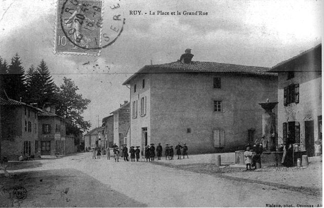

Ruy-Montceau
- commune in Isère, France
Hiking in Ruy-Montceau
Ruy, located in the Isère department of southeastern France, is a charming area that offers a variety of hiking opportunities, taking advantage of the beautiful natural landscapes of the region. Although Ruy itself may not be as widely recognized for hiking as some other areas in the Alps, it's conveniently located near various trails and natural parks that are ideal for outdoor enthusiasts....
- Country:
- Postal Code: 38300
- Coordinates: 45° 35' 18" N, 5° 19' 4" E
- GPS tracks (wikiloc): [Link]
- Area: 20.81 sq km
- Population: 4434
- Web site: [Link]
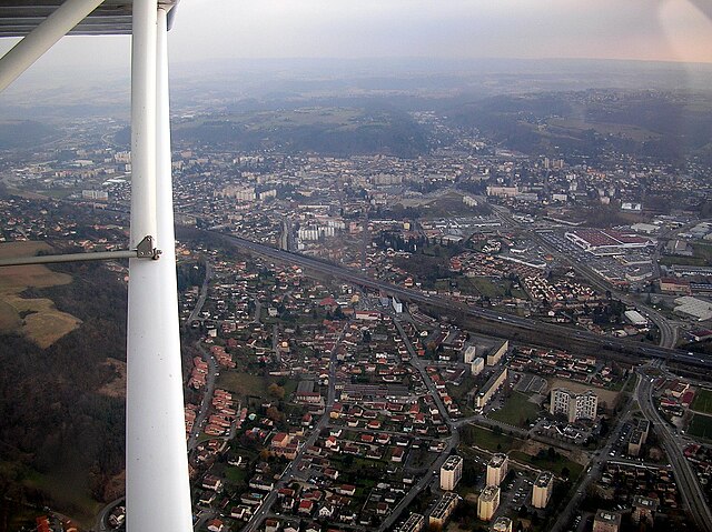

Bourgoin-Jallieu
- commune in Isère, France
Hiking in Bourgoin-Jallieu
Bourgoin-Jallieu, located in the Auvergne-Rhône-Alpes region of eastern France, offers a variety of hiking opportunities for outdoor enthusiasts. The town is nestled between the Isère River and the Chartreuse Mountains, providing both flat terrain and more challenging trails....
- Country:
- Postal Code: 38300
- Coordinates: 45° 35' 27" N, 5° 16' 45" E
- GPS tracks (wikiloc): [Link]
- AboveSeaLevel: 254 м m
- Area: 24.37 sq km
- Population: 27502
- Web site: [Link]


Saint-Marcel-Bel-Accueil
- commune in Isère, France
Hiking in Saint-Marcel-Bel-Accueil
Saint-Marcel-Bel-Accueil is a charming commune located in the Auvergne-Rhône-Alpes region of France. While it may not be as well-known as some major hiking destinations, it provides opportunities for outdoor enthusiasts to explore beautiful natural landscapes....
- Country:
- Postal Code: 38080
- Coordinates: 45° 38' 51" N, 5° 14' 9" E
- GPS tracks (wikiloc): [Link]
- Area: 18.23 sq km
- Population: 1357
- Web site: [Link]


Saint-Chef
- commune in Isère, France
Hiking in Saint-Chef
Saint-Chef is a charming commune located in the Isère department of the Auvergne-Rhône-Alpes region in southeastern France. The area is known for its beautiful landscapes, rolling hills, and rich natural surroundings, making it an attractive destination for hikers of all levels....
- Country:
- Postal Code: 38890
- Coordinates: 45° 38' 2" N, 5° 21' 57" E
- GPS tracks (wikiloc): [Link]
- Area: 27.16 sq km
- Population: 3620
- Web site: [Link]