Saint-Savin (Saint-Savin)

- commune in Isère, France
 Hiking in Saint-Savin
Saint-Savin, located in the Isère department of the Auvergne-Rhône-Alpes region of France, is a charming village known for its natural beauty and access to various hiking trails. The area features stunning landscapes, rolling hills, and proximity to the Chartreuse and Vercors mountain ranges, making it a great destination for outdoor enthusiasts.
Hiking Trails:
-
Local Trails: There are several marked trails around Saint-Savin that cater to different skill levels. These trails often include lush forests, meadows, and picturesque views of the surrounding mountains.
-
Plateau de l'Isère: A bit further away but accessible from Saint-Savin, this plateau offers varied hiking options with stunning vistas and diverse flora and fauna.
-
Chartreuse Mountains: Just a short drive away, the Chartreuse massif provides an array of trails. Popular hikes include those to the various col (mountain passes) and peaks, such as the Granier or Chamechaude.
-
Vercors Regional Natural Park: To the south, Vercors offers breathtaking landscapes and challenging hikes. Here, you can explore deep gorges, alpine meadows, and fascinating limestone formations.
Tips for Hiking in Saint-Savin:
- Preparation: Always check the weather before heading out and dress in layers, as mountain weather can change rapidly.
- Maps and Guides: Carry a detailed map or a GPS device to navigate the trails, as signage may not always be available.
- Local Regulations: Be mindful of local wildlife and adhere to any guidance regarding trail usage and conservation efforts.
- Safety: Hike with a buddy when possible, and let someone know your planned route and expected return time.
Best Time to Hike:
The best seasons for hiking in and around Saint-Savin are typically late spring through early autumn, when the trails are accessible and the weather is mild. However, the region can also offer stunning winter hikes, especially if you have the right equipment for snow conditions.
Overall, hiking in Saint-Savin offers a wonderful opportunity to immerse yourself in nature while enjoying some of the best views that the Isère region has to offer.
- Country:

- Postal Code: 38300
- Coordinates: 45° 37' 43" N, 5° 18' 22" E


- GPS tracks (wikiloc): [Link]
- Area: 24.55 sq km
- Population: 3967
- Web site: http://www.mairie-st-savin.fr
- Wikipedia en: wiki(en)
- Wikipedia: wiki(fr)
- Wikidata storage: Wikidata: Q1109808
- Wikipedia Commons Gallery: [Link]
- Wikipedia Commons Category: [Link]
- Freebase ID: [/m/03g_5s9]
- GeoNames ID: Alt: [6433396]
- SIREN number: [213804552]
- BnF ID: [152582628]
- VIAF ID: Alt: [142013967]
- INSEE municipality code: 38455
Shares border with regions:

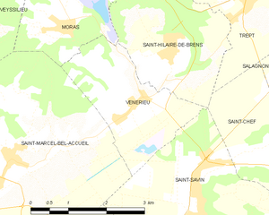
Vénérieu
- commune in Isère, France
Hiking in Vénérieu
Vénérieu is a small commune located in the Isère department of the Auvergne-Rhône-Alpes region in southeastern France. While it may not be as famous as other hiking destinations, it can offer some charming walking and hiking opportunities, especially for those looking to explore the lesser-known paths of the French countryside....
- Country:
- Postal Code: 38460
- Coordinates: 45° 39' 33" N, 5° 16' 39" E
- GPS tracks (wikiloc): [Link]
- Area: 6 sq km
- Population: 753
- Web site: [Link]

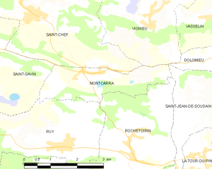
Montcarra
- commune in Isère, France
Hiking in Montcarra
Montcarra, located in the Isère department of southeastern France, is a beautiful area known for its scenic landscapes and outdoor activities. While it may not be as widely recognized as some of the larger national parks in the Alps, it offers a variety of hiking opportunities that can cater to different skill levels and preferences....
- Country:
- Postal Code: 38890
- Coordinates: 45° 36' 47" N, 5° 23' 29" E
- GPS tracks (wikiloc): [Link]
- Area: 4.9 sq km
- Population: 519
- Web site: [Link]
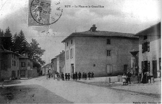

Ruy-Montceau
- commune in Isère, France
Hiking in Ruy-Montceau
Ruy, located in the Isère department of southeastern France, is a charming area that offers a variety of hiking opportunities, taking advantage of the beautiful natural landscapes of the region. Although Ruy itself may not be as widely recognized for hiking as some other areas in the Alps, it's conveniently located near various trails and natural parks that are ideal for outdoor enthusiasts....
- Country:
- Postal Code: 38300
- Coordinates: 45° 35' 18" N, 5° 19' 4" E
- GPS tracks (wikiloc): [Link]
- Area: 20.81 sq km
- Population: 4434
- Web site: [Link]
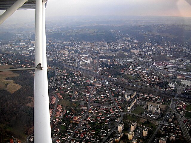

Bourgoin-Jallieu
- commune in Isère, France
Hiking in Bourgoin-Jallieu
Bourgoin-Jallieu, located in the Auvergne-Rhône-Alpes region of eastern France, offers a variety of hiking opportunities for outdoor enthusiasts. The town is nestled between the Isère River and the Chartreuse Mountains, providing both flat terrain and more challenging trails....
- Country:
- Postal Code: 38300
- Coordinates: 45° 35' 27" N, 5° 16' 45" E
- GPS tracks (wikiloc): [Link]
- AboveSeaLevel: 254 м m
- Area: 24.37 sq km
- Population: 27502
- Web site: [Link]


Saint-Marcel-Bel-Accueil
- commune in Isère, France
Hiking in Saint-Marcel-Bel-Accueil
Saint-Marcel-Bel-Accueil is a charming commune located in the Auvergne-Rhône-Alpes region of France. While it may not be as well-known as some major hiking destinations, it provides opportunities for outdoor enthusiasts to explore beautiful natural landscapes....
- Country:
- Postal Code: 38080
- Coordinates: 45° 38' 51" N, 5° 14' 9" E
- GPS tracks (wikiloc): [Link]
- Area: 18.23 sq km
- Population: 1357
- Web site: [Link]


Saint-Chef
- commune in Isère, France
Hiking in Saint-Chef
Saint-Chef is a charming commune located in the Isère department of the Auvergne-Rhône-Alpes region in southeastern France. The area is known for its beautiful landscapes, rolling hills, and rich natural surroundings, making it an attractive destination for hikers of all levels....
- Country:
- Postal Code: 38890
- Coordinates: 45° 38' 2" N, 5° 21' 57" E
- GPS tracks (wikiloc): [Link]
- Area: 27.16 sq km
- Population: 3620
- Web site: [Link]