Ruy-Montceau (Ruy-Montceau)

- commune in Isère, France
 Hiking in Ruy-Montceau
Ruy, located in the Isère department of southeastern France, is a charming area that offers a variety of hiking opportunities, taking advantage of the beautiful natural landscapes of the region. Although Ruy itself may not be as widely recognized for hiking as some other areas in the Alps, it's conveniently located near various trails and natural parks that are ideal for outdoor enthusiasts.
Nearby Hiking Areas:
-
Chartreuse Regional Natural Park: Just a short drive from Ruy, this park is home to stunning mountain scenery, diverse flora and fauna, and a network of trails for all skill levels. The hikes range from gentle walks to more challenging routes, often leading to breathtaking views from mountain summits.
-
Vercors Regional Natural Park: To the south, this park offers dramatic limestone cliffs and extensive hiking routes. The Vercors is particularly known for its panoramic views and diverse ecosystems, making it a great destination for day hikes or longer excursions.
-
Alpe d'Huez and Oisans: A bit farther afield, the Oisans region near Alpe d'Huez is celebrated for its alpine scenery. Here, you'll find numerous hiking trails that cater to all levels, from leisurely walks to challenging hikes with significant altitude gain.
Popular Hiking Trails:
- Sentier de la Roche Courbe: Located in the Chartreuse area, this trail is a moderate hike with rewarding views at the summit.
- Gorges de la Bourne: This is a lovely scenic route that takes you through impressive gorges. It is suitable for hikers looking for beautiful landscapes and a relatively easy walking experience.
- Col de la Sarenne: A more challenging route, this hike will lead you to panoramic viewpoints over the surrounding mountain ranges.
Best Time to Hike:
The best times for hiking in the Ruy area typically span from late spring to early autumn (May to October) when the weather is milder, and the trails are more accessible. Summer can be ideal for high-altitude hikes, while late spring and early autumn are perfect for enjoying the vibrant wildflowers and fall foliage.
Tips for Hikers:
- Check Weather Conditions: Mountain weather can be unpredictable, so always check the forecast and be prepared for changing conditions.
- Stay Hydrated and Pack Essentials: Bring plenty of water, snacks, and essential gear such as first aid kits, layers of clothing, and navigation tools.
- Respect Nature: Stay on designated trails to protect local wildlife and plant life.
- Consider Local Guides: If you're unfamiliar with the area, consider hiring a local guide for expert insights and to enhance your hiking experience.
Overall, Ruy offers a great starting point for exploring the natural beauty of the Isère region. Enjoy your hiking adventures!
- Country:

- Postal Code: 38300
- Coordinates: 45° 35' 18" N, 5° 19' 4" E


- GPS tracks (wikiloc): [Link]
- Area: 20.81 sq km
- Population: 4434
- Web site: http://www.ruy-montceau.fr
- Wikipedia en: wiki(en)
- Wikipedia: wiki(fr)
- Wikidata storage: Wikidata: Q1154576
- Wikipedia Commons Category: [Link]
- Freebase ID: [/m/03nw7l9]
- GeoNames ID: Alt: [6433312]
- SIREN number: [213803489]
- BnF ID: [152581593]
- INSEE municipality code: 38348
Shares border with regions:


Cessieu
- commune in Isère, France
Hiking in Cessieu
Cessieu is a charming commune located in the Auvergne-Rhône-Alpes region of France, nestled between the Rhône River and the foothills of the Alps. Although it may not be as widely recognized as some other hiking destinations, it offers various opportunities for outdoor enthusiasts....
- Country:
- Postal Code: 38110
- Coordinates: 45° 34' 0" N, 5° 22' 36" E
- GPS tracks (wikiloc): [Link]
- Area: 14.35 sq km
- Population: 2886
- Web site: [Link]
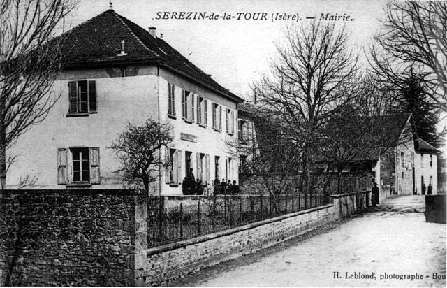

Sérézin-de-la-Tour
- commune in Isère, France
Hiking in Sérézin-de-la-Tour
Sérézin-de-la-Tour, nestled in the Auvergne-Rhône-Alpes region of France, offers charming hiking opportunities that attract both locals and visitors. The area is characterized by beautiful natural landscapes, including rolling hills, forests, and scenic views of the surrounding countryside....
- Country:
- Postal Code: 38300
- Coordinates: 45° 33' 27" N, 5° 20' 39" E
- GPS tracks (wikiloc): [Link]
- Area: 9.31 sq km
- Population: 1011
- Web site: [Link]


Nivolas-Vermelle
- commune in Isère, France
Hiking in Nivolas-Vermelle
Nivolas-Vermelle is a charming commune located in the Auvergne-Rhône-Alpes region of southeastern France. While it may not be as widely known for hiking as some other regions in the Alps, it still offers beautiful natural surroundings and various outdoor activities....
- Country:
- Postal Code: 38300
- Coordinates: 45° 33' 24" N, 5° 18' 23" E
- GPS tracks (wikiloc): [Link]
- Area: 6.09 sq km
- Population: 2536
- Web site: [Link]

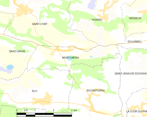
Montcarra
- commune in Isère, France
Hiking in Montcarra
Montcarra, located in the Isère department of southeastern France, is a beautiful area known for its scenic landscapes and outdoor activities. While it may not be as widely recognized as some of the larger national parks in the Alps, it offers a variety of hiking opportunities that can cater to different skill levels and preferences....
- Country:
- Postal Code: 38890
- Coordinates: 45° 36' 47" N, 5° 23' 29" E
- GPS tracks (wikiloc): [Link]
- Area: 4.9 sq km
- Population: 519
- Web site: [Link]


Saint-Savin
- commune in Isère, France
Hiking in Saint-Savin
Saint-Savin, located in the Isère department of the Auvergne-Rhône-Alpes region of France, is a charming village known for its natural beauty and access to various hiking trails. The area features stunning landscapes, rolling hills, and proximity to the Chartreuse and Vercors mountain ranges, making it a great destination for outdoor enthusiasts....
- Country:
- Postal Code: 38300
- Coordinates: 45° 37' 43" N, 5° 18' 22" E
- GPS tracks (wikiloc): [Link]
- Area: 24.55 sq km
- Population: 3967
- Web site: [Link]
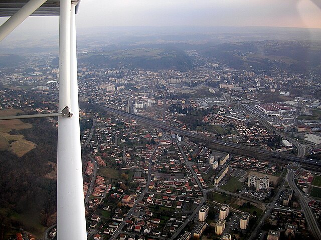

Bourgoin-Jallieu
- commune in Isère, France
Hiking in Bourgoin-Jallieu
Bourgoin-Jallieu, located in the Auvergne-Rhône-Alpes region of eastern France, offers a variety of hiking opportunities for outdoor enthusiasts. The town is nestled between the Isère River and the Chartreuse Mountains, providing both flat terrain and more challenging trails....
- Country:
- Postal Code: 38300
- Coordinates: 45° 35' 27" N, 5° 16' 45" E
- GPS tracks (wikiloc): [Link]
- AboveSeaLevel: 254 м m
- Area: 24.37 sq km
- Population: 27502
- Web site: [Link]

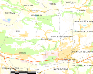
Rochetoirin
- commune in Isère, France
Hiking in Rochetoirin
Rochetoirin, located in the Auvergne-Rhône-Alpes region of France, is a charming destination for hiking enthusiasts. Nestled near the foothills of the Chartreuse Mountains, the area offers a variety of natural landscapes, from rolling hills to picturesque forests, and a glimpse of local flora and fauna....
- Country:
- Postal Code: 38110
- Coordinates: 45° 34' 54" N, 5° 25' 5" E
- GPS tracks (wikiloc): [Link]
- Area: 10.62 sq km
- Population: 1115
- Web site: [Link]