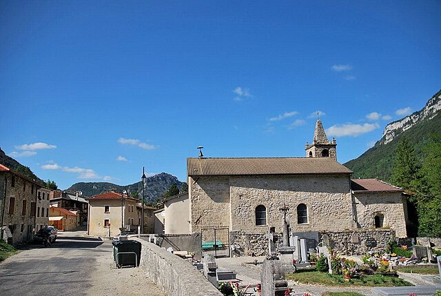
Vassieux-en-Vercors (Vassieux-en-Vercors)

- commune in Drôme, France
 Hiking in Vassieux-en-Vercors
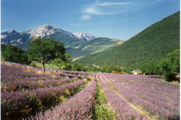
Vassieux-en-Vercors is a beautiful village located in the Vercors Regional Natural Park in France, known for its stunning natural landscapes and outdoor activities, especially hiking. The area is characterized by its dramatic limestone cliffs, dense forests, and rich biodiversity, making it an ideal destination for hikers of all levels.
Hiking Trails
-
La Montagne de la Molière: This hike offers breathtaking panoramic views of the surrounding landscape, including the majestic Vercors mountains. It’s a relatively moderate hike that can be completed in a few hours.
-
The Plateau de Vercors: A network of trails that wind through the picturesque plateau, where you can enjoy a variety of landscapes, from meadows to rocky outcrops. There are several waymarked routes, suitable for both casual walkers and experienced hikers.
-
Col de la Bataille: This trail offers a more challenging hike, leading to the Col de la Bataille with stunning views over the cliffs and valleys surrounding Vassieux-en-Vercors.
-
The Grotte de la Luire: This hike not only takes you through beautiful forested areas but also leads to fascinating geological features, including the impressive cave at La Luire.
Best Time to Hike
The best seasons for hiking in Vassieux-en-Vercors are spring (April to June) and autumn (September to October) when the weather is mild, and the natural scenery is at its most vibrant. Summer can also be a great time, but it may get crowded on popular trails. Winter offers opportunities for snowshoeing and winter hiking if you’re prepared for colder temperatures and possible snow.
Tips for Hikers
- Gear Up: Make sure to wear suitable hiking footwear and carry a backpack with water, snacks, a map, and first-aid supplies.
- Stay on Marked Trails: To protect the local ecosystem and for your own safety, it's important to stick to marked paths.
- Respect Wildlife: The area is home to diverse flora and fauna, so observe animals from a distance and do not disturb their habitats.
- Weather Preparedness: The weather can change quickly in the mountains, so be sure to check forecasts before heading out and be prepared for rain or changes in temperature.
Vassieux-en-Vercors provides a great blend of outdoor adventure, natural beauty, and cultural heritage, making it a wonderful spot for hiking enthusiasts. Enjoy your trek!
- Country:

- Postal Code: 26420
- Coordinates: 44° 53' 43" N, 5° 22' 13" E


- GPS tracks (wikiloc): [Link]
- Area: 48.25 sq km
- Population: 318
- Web site: http://www.vassieuxenvercors.fr/
- Wikipedia en: wiki(en)
- Wikipedia: wiki(fr)
- Wikidata storage: Wikidata: Q266211
- Wikipedia Commons Category: [Link]
- Freebase ID: [/m/03h3slm]
- GeoNames ID: Alt: [2970622]
- SIREN number: [212603641]
- BnF ID: [15253224h]
- VIAF ID: Alt: [288638587]
- Library of Congress authority ID: Alt: [n78010424]
- PACTOLS thesaurus ID: [pcrthc0OQ1ygZF]
- INSEE municipality code: 26364
Shares border with regions:
Saint-Agnan-en-Vercors
- commune in Drôme, France
Hiking in Saint-Agnan-en-Vercors
Saint-Agnan-en-Vercors is a charming village located in the Vercors Massif, part of the French Pre-Alps. This area is known for its stunning landscapes, rich biodiversity, and extensive network of hiking trails, making it a fantastic destination for both novice and experienced hikers....
- Country:
- Postal Code: 26420
- Coordinates: 44° 56' 8" N, 5° 25' 52" E
- GPS tracks (wikiloc): [Link]
- Area: 84.21 sq km
- Population: 397

Bouvante
- commune in Drôme, France
Hiking in Bouvante
Bouvante is a charming commune located in the Isère department of the Auvergne-Rhône-Alpes region in southeastern France. It is surrounded by breathtaking landscapes, characterized by rolling hills, forests, and mountainous terrain, which makes it a great destination for hiking enthusiasts....
- Country:
- Postal Code: 26190
- Coordinates: 44° 57' 52" N, 5° 16' 14" E
- GPS tracks (wikiloc): [Link]
- AboveSeaLevel: 585 м m
- Area: 83.88 sq km
- Population: 252
Marignac-en-Diois
- commune in Drôme, France
Hiking in Marignac-en-Diois
Marignac-en-Diois is a picturesque village located in the Drôme department of southeastern France, nestled in the heart of the Diois region. This area is known for its stunning natural landscapes, making it an excellent destination for hiking enthusiasts....
- Country:
- Postal Code: 26150
- Coordinates: 44° 48' 9" N, 5° 20' 1" E
- GPS tracks (wikiloc): [Link]
- Area: 18.26 sq km
- Population: 204

Chamaloc
- commune in Drôme, France
Hiking in Chamaloc
Chamaloc, located in the Île-de-France region of France, is a lesser-known destination for hiking enthusiasts. While it may not be as famous as other hiking hotspots in France, it offers beautifully scenic trails and a peaceful escape into nature. Here’s what you need to know about hiking in and around Chamaloc:...
- Country:
- Postal Code: 26150
- Coordinates: 44° 47' 55" N, 5° 23' 2" E
- GPS tracks (wikiloc): [Link]
- Area: 21.89 sq km
- Population: 129


La Chapelle-en-Vercors
- commune in Drôme, France
Hiking in La Chapelle-en-Vercors
La Chapelle-en-Vercors is a beautiful village located in the Vercors Regional Natural Park in the Auvergne-Rhône-Alpes region of France. This area is renowned for its stunning landscapes, diverse flora and fauna, and a variety of hiking trails suitable for different skill levels. Here’s what you can expect from hiking in this area:...
- Country:
- Postal Code: 26420
- Coordinates: 44° 58' 4" N, 5° 24' 59" E
- GPS tracks (wikiloc): [Link]
- Area: 45.27 sq km
- Population: 685
Saint-Julien-en-Quint
- commune in Drôme, France
Hiking in Saint-Julien-en-Quint
Saint-Julien-en-Quint is a beautiful commune located in the Rhône-Alpes region of France, known for its stunning natural landscapes and outdoor recreational opportunities. Here are some key points about hiking in this area:...
- Country:
- Postal Code: 26150
- Coordinates: 44° 50' 16" N, 5° 17' 32" E
- GPS tracks (wikiloc): [Link]
- Area: 47.35 sq km
- Population: 157