canton of Libourne (canton de Libourne)
- canton of France
- Country:

- Capital: Libourne
- Coordinates: 44° 54' 36" N, 0° 14' 49" E


- GPS tracks (wikiloc): [Link]
- Wikidata storage: Wikidata: Q1725903
- INSEE canton code: [3330]
Includes regions:


Saint-Sulpice-de-Faleyrens
- commune in Gironde, France
- Country:
- Postal Code: 33330
- Coordinates: 44° 52' 28" N, 0° 11' 25" E
- GPS tracks (wikiloc): [Link]
- Area: 18.17 sq km
- Population: 1410
- Web site: [Link]


Vayres
- commune in Gironde, France
- Country:
- Postal Code: 33870
- Coordinates: 44° 53' 50" N, 0° 18' 52" E
- GPS tracks (wikiloc): [Link]
- Area: 14.46 sq km
- Population: 3765
- Web site: [Link]

Lalande-de-Pomerol
- commune in Gironde, France
- Country:
- Postal Code: 33500
- Coordinates: 44° 57' 20" N, 0° 12' 33" E
- GPS tracks (wikiloc): [Link]
- AboveSeaLevel: 10 м m
- Area: 8.25 sq km
- Population: 669
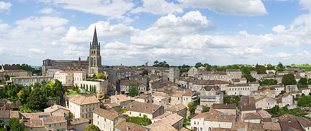

Saint-Émilion
- commune in Gironde, France
- Country:
- Postal Code: 33330
- Coordinates: 44° 53' 34" N, 0° 9' 21" E
- GPS tracks (wikiloc): [Link]
- AboveSeaLevel: 23 м m
- Area: 27.02 sq km
- Population: 1878
- Web site: [Link]
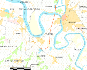
Arveyres
- commune in Gironde, France
- Country:
- Postal Code: 33500
- Coordinates: 44° 53' 3" N, 0° 17' 0" E
- GPS tracks (wikiloc): [Link]
- Area: 17.27 sq km
- Population: 1930
- Web site: [Link]


Libourne
- commune in Gironde, France
- Country:
- Postal Code: 33500
- Coordinates: 44° 54' 55" N, 0° 14' 38" E
- GPS tracks (wikiloc): [Link]
- AboveSeaLevel: 15 м m
- Area: 20.63 sq km
- Population: 24866
- Web site: [Link]


Les Billaux
- commune in Gironde, France
- Country:
- Postal Code: 33500
- Coordinates: 44° 57' 9" N, 0° 14' 13" E
- GPS tracks (wikiloc): [Link]
- Area: 6.26 sq km
- Population: 1196
- Web site: [Link]


Cadarsac
- commune in Gironde, France
- Country:
- Postal Code: 33750
- Coordinates: 44° 51' 38" N, 0° 17' 10" E
- GPS tracks (wikiloc): [Link]
- Area: 2.28 sq km
- Population: 342


Pomerol
- commune in Gironde, France
- Country:
- Postal Code: 33500
- Coordinates: 44° 55' 55" N, 0° 12' 1" E
- GPS tracks (wikiloc): [Link]
- Area: 6.24 sq km
- Population: 642


Izon
- commune in Gironde, France
- Country:
- Postal Code: 33450
- Coordinates: 44° 55' 13" N, 0° 21' 43" E
- GPS tracks (wikiloc): [Link]
- Area: 15.59 sq km
- Population: 5573