Lalande-de-Pomerol (Lalande-de-Pomerol)

- commune in Gironde, France
- Country:

- Postal Code: 33500
- Coordinates: 44° 57' 20" N, 0° 12' 33" E


- GPS tracks (wikiloc): [Link]
- AboveSeaLevel: 10 м m
- Area: 8.25 sq km
- Population: 669
- Wikipedia en: wiki(en)
- Wikipedia: wiki(fr)
- Wikidata storage: Wikidata: Q185436
- Wikipedia Commons Category: [Link]
- Freebase ID: [/m/03nrzzm]
- GeoNames ID: Alt: [6616553]
- SIREN number: [213302227]
- BnF ID: [15256274s]
- INSEE municipality code: 33222
Shares border with regions:


Montagne
- commune in Gironde, France
- Country:
- Postal Code: 33570
- Coordinates: 44° 55' 49" N, 0° 7' 46" E
- GPS tracks (wikiloc): [Link]
- Area: 26.66 sq km
- Population: 1554
- Web site: [Link]

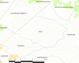
Néac
- commune in Gironde, France
- Country:
- Postal Code: 33500
- Coordinates: 44° 56' 26" N, 0° 10' 45" E
- GPS tracks (wikiloc): [Link]
- Area: 6.88 sq km
- Population: 405


Libourne
- commune in Gironde, France
- Country:
- Postal Code: 33500
- Coordinates: 44° 54' 55" N, 0° 14' 38" E
- GPS tracks (wikiloc): [Link]
- AboveSeaLevel: 15 м m
- Area: 20.63 sq km
- Population: 24866
- Web site: [Link]


Les Billaux
- commune in Gironde, France
- Country:
- Postal Code: 33500
- Coordinates: 44° 57' 9" N, 0° 14' 13" E
- GPS tracks (wikiloc): [Link]
- Area: 6.26 sq km
- Population: 1196
- Web site: [Link]

Saint-Denis-de-Pile
- commune in Gironde, France
- Country:
- Postal Code: 33910
- Coordinates: 44° 59' 30" N, 0° 12' 22" E
- GPS tracks (wikiloc): [Link]
- Area: 28.27 sq km
- Population: 5302


Pomerol
- commune in Gironde, France
- Country:
- Postal Code: 33500
- Coordinates: 44° 55' 55" N, 0° 12' 1" E
- GPS tracks (wikiloc): [Link]
- Area: 6.24 sq km
- Population: 642