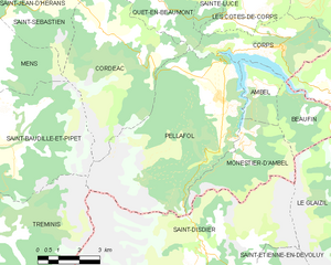
Tréminis (Tréminis)

- commune in Isère, France
 Hiking in Tréminis
Tréminis is a charming village located in the Isère department of the Auvergne-Rhône-Alpes region in southeastern France. It’s known for its beautiful landscapes and outdoor activities, making it a great spot for hiking enthusiasts.
Hiking Trails:
-
Les Sentiers de Tréminis: The area offers various marked trails that cater to different skill levels, ranging from easy walks suitable for families to more challenging hikes for experienced trekkers. The routes often provide stunning views of the surrounding mountains, valleys, and the Vercors Massif.
-
The Circuit of Mont Aiguille: This is a popular hike among more adventurous hikers. It provides incredible panoramas of Mont Aiguille and the surrounding peaks. The trail often features rocky terrain and can require some scrambling.
-
Natural Environment: The region is rich in biodiversity, with a variety of flora and fauna. Hiking in Tréminis offers the chance to see local wildlife and enjoy the serene atmosphere of the French Alps.
Best Time to Hike:
- Spring (April to June): Ideal for wildflowers and mild weather.
- Summer (July to August): Perfect for hiking but can get crowded on popular trails.
- Autumn (September to October): Offers stunning fall colors, and cooler temperatures make hiking enjoyable.
- Winter (December to March): Great for snowshoeing in the area, though some trails may be more challenging due to snow and ice.
Tips for Hiking in Tréminis:
- Prepare Properly: Ensure you have the right gear, including sturdy hiking boots, weather-appropriate clothing, and plenty of water and snacks.
- Check Trail Conditions: Before heading out, verify the trail conditions and weather forecast.
- Local Guides: Consider hiring a local guide for more challenging hikes or to learn more about the region's natural history.
Safety and Considerations:
- Always inform someone about your hike plan and expected return time.
- Maps and GPS devices can help navigate trails, but it's still wise to carry a physical map as a backup.
- Respect the environment by sticking to marked trails and following local regulations.
Overall, Tréminis offers a wonderful hiking experience with its stunning natural beauty and diverse trails, making it an excellent destination for both casual walkers and serious trekkers.
- Country:

- Postal Code: 38710
- Coordinates: 44° 44' 51" N, 5° 46' 8" E


- GPS tracks (wikiloc): [Link]
- Area: 49.4 sq km
- Population: 180
- Wikipedia en: wiki(en)
- Wikipedia: wiki(fr)
- Wikidata storage: Wikidata: Q774468
- Wikipedia Commons Category: [Link]
- Freebase ID: [/m/03nvkq_]
- GeoNames ID: Alt: [6433433]
- SIREN number: [213805146]
- BnF ID: [15258314p]
- INSEE municipality code: 38514
Shares border with regions:

Saint-Disdier
- former commune in Hautes-Alpes, France
Hiking in Saint-Disdier
Saint-Disdier, located in the Hautes-Alpes region of France, offers a wonderful environment for hiking enthusiasts. Surrounded by the stunning landscapes of the Southern French Alps, the area is known for its picturesque trails, diverse ecosystems, and breathtaking views....
- Country:
- Postal Code: 05250
- Coordinates: 44° 44' 0" N, 5° 54' 0" E
- GPS tracks (wikiloc): [Link]
- AboveSeaLevel: 1040 м m
- Population: 139

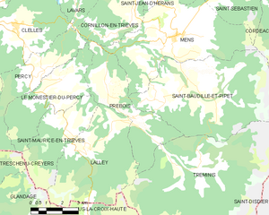
Pellafol
- commune in Isère, France
Hiking in Pellafol
Pellafol, a picturesque village located in the Isère department of the Auvergne-Rhône-Alpes region in France, is a hidden gem for hiking enthusiasts. Nestled in the foothills of the French Alps, it offers stunning landscapes, diverse flora and fauna, and a variety of trails suitable for all skill levels....
- Country:
- Postal Code: 38970
- Coordinates: 44° 47' 51" N, 5° 54' 27" E
- GPS tracks (wikiloc): [Link]
- Area: 34.73 sq km
- Population: 137


Saint-Baudille-et-Pipet
- commune in Isère, France
Hiking in Saint-Baudille-et-Pipet
Saint-Baudille-et-Pipet is a charming commune located in the Auvergne-Rhône-Alpes region of France, surrounded by beautiful natural landscapes that are perfect for hiking enthusiasts. The area offers a variety of trails that cater to different skill levels, making it an excellent destination for both novices and experienced hikers....
- Country:
- Postal Code: 38710
- Coordinates: 44° 47' 3" N, 5° 46' 7" E
- GPS tracks (wikiloc): [Link]
- Area: 35.97 sq km
- Population: 257


Lalley
- commune in Isère, France
Hiking in Lalley
Lalley, located in the northern part of the United States, specifically in New Hampshire's White Mountains, offers a variety of hiking opportunities for all skill levels. The area is known for its stunning natural beauty, including dense forests, mountain streams, and panoramic views. Here are some highlights of hiking in Lalley:...
- Country:
- Postal Code: 38930
- Coordinates: 44° 45' 28" N, 5° 40' 34" E
- GPS tracks (wikiloc): [Link]
- Area: 23.65 sq km
- Population: 201
- Web site: [Link]

Prébois
- commune in Isère, France
Hiking in Prébois
Prébois is a scenic area located in the French Alps, known for its stunning landscapes, diverse flora and fauna, and hiking opportunities. Here are some key points to consider if you're planning a hike in Prébois:...
- Country:
- Postal Code: 38710
- Coordinates: 44° 47' 22" N, 5° 41' 42" E
- GPS tracks (wikiloc): [Link]
- Area: 16.03 sq km
- Population: 165
- Web site: [Link]
Dévoluy
- commune in Hautes-Alpes, France
Hiking in Dévoluy
Le Dévoluy is a stunning mountain range located in the French Alps, known for its diverse landscapes, breathtaking scenery, and extensive hiking opportunities. Whether you're an experienced hiker or a beginner, there's something for everyone in this area....
- Country:
- Postal Code: 05250
- Coordinates: 44° 41' 33" N, 5° 56' 28" E
- GPS tracks (wikiloc): [Link]
- Area: 186.37 sq km
- Population: 1011
- Web site: [Link]


Lus-la-Croix-Haute
- commune in Drôme, France
Hiking in Lus-la-Croix-Haute
Lus-la-Croix-Haute is a beautiful destination for hiking enthusiasts, located in the picturesque Alps of France. This charming village offers a variety of trails that cater to different levels of hikers, from beginners to experienced adventurers....
- Country:
- Postal Code: 26620
- Coordinates: 44° 39' 55" N, 5° 42' 20" E
- GPS tracks (wikiloc): [Link]
- Area: 87.2 sq km
- Population: 549