Verlus (Verlus)

- commune in Gers, France
- Country:

- Postal Code: 32400
- Coordinates: 43° 36' 8" N, 0° 11' 48" E


- GPS tracks (wikiloc): [Link]
- Area: 6.19 sq km
- Population: 93
- Wikipedia en: wiki(en)
- Wikipedia: wiki(fr)
- Wikidata storage: Wikidata: Q1005776
- Wikipedia Commons Category: [Link]
- Freebase ID: [/m/03nrvs9]
- GeoNames ID: Alt: [6432167]
- SIREN number: [213204613]
- BnF ID: [15256047b]
- INSEE municipality code: 32461
Shares border with regions:

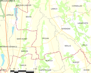
Projan
- commune in Gers, France
- Country:
- Postal Code: 32400
- Coordinates: 43° 35' 58" N, 0° 14' 14" E
- GPS tracks (wikiloc): [Link]
- Area: 11.78 sq km
- Population: 177

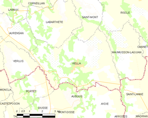
Viella
- commune in Gers, France
- Country:
- Postal Code: 32400
- Coordinates: 43° 35' 55" N, 0° 8' 24" E
- GPS tracks (wikiloc): [Link]
- AboveSeaLevel: 241 м m
- Area: 22.02 sq km
- Population: 529


Moncla
- commune in Pyrénées-Atlantiques, France
- Country:
- Postal Code: 64330
- Coordinates: 43° 34' 54" N, 0° 13' 59" E
- GPS tracks (wikiloc): [Link]
- Area: 5.83 sq km
- Population: 106
Portet
- commune in Pyrénées-Atlantiques, France
- Country:
- Postal Code: 64330
- Coordinates: 43° 34' 45" N, 0° 11' 13" E
- GPS tracks (wikiloc): [Link]
- Area: 7.89 sq km
- Population: 171


Aurensan
- commune in Gers, France
- Country:
- Postal Code: 32400
- Coordinates: 43° 37' 5" N, 0° 12' 13" E
- GPS tracks (wikiloc): [Link]
- AboveSeaLevel: 170 м m
- Area: 6.33 sq km
- Population: 135