canton of Albert (canton d'Albert)

- canton of France
- Country:

- Capital: Albert
- Coordinates: 50° 0' 10" N, 2° 39' 10" E


- GPS tracks (wikiloc): [Link]
- Population: 28419
- Wikipedia en: wiki(en)
- Wikipedia: wiki(fr)
- Wikidata storage: Wikidata: Q137493
- Freebase ID: [/m/03y1f4z]
- Library of Congress authority ID: Alt: [nr95009932]
- INSEE canton code: [8005]
Includes regions:


Bécordel-Bécourt
- commune in Somme, France
- Country:
- Postal Code: 80300
- Coordinates: 49° 59' 23" N, 2° 41' 8" E
- GPS tracks (wikiloc): [Link]
- Area: 3.57 sq km
- Population: 162
- Web site: [Link]


Buire-sur-l'Ancre
- commune in Somme, France
- Country:
- Postal Code: 80300
- Coordinates: 49° 57' 54" N, 2° 35' 32" E
- GPS tracks (wikiloc): [Link]
- Area: 5.28 sq km
- Population: 309
- Web site: [Link]

Beaucourt-sur-l'Ancre
- commune in Somme, France
- Country:
- Postal Code: 80300
- Coordinates: 50° 4' 48" N, 2° 41' 9" E
- GPS tracks (wikiloc): [Link]
- Area: 3.51 sq km
- Population: 97
- Web site: [Link]


Irles
- commune in Somme, France
- Country:
- Postal Code: 80300
- Coordinates: 50° 5' 58" N, 2° 45' 13" E
- GPS tracks (wikiloc): [Link]
- Area: 5.38 sq km
- Population: 100
- Web site: [Link]

Fricourt
- commune in Somme, France
- Country:
- Postal Code: 80300
- Coordinates: 49° 59' 53" N, 2° 42' 54" E
- GPS tracks (wikiloc): [Link]
- Area: 11.3 sq km
- Population: 499
- Web site: [Link]


Grandcourt
- commune in Somme, France
- Country:
- Postal Code: 80300
- Coordinates: 50° 4' 46" N, 2° 42' 34" E
- GPS tracks (wikiloc): [Link]
- Area: 8.38 sq km
- Population: 177
- Web site: [Link]


Pys
- commune in Somme, France
- Country:
- Postal Code: 80300
- Coordinates: 50° 5' 13" N, 2° 45' 24" E
- GPS tracks (wikiloc): [Link]
- AboveSeaLevel: 115 м m
- Area: 5.05 sq km
- Population: 118
- Web site: [Link]


Albert
- commune in Somme, France
- Country:
- Postal Code: 80300
- Coordinates: 50° 0' 7" N, 2° 39' 8" E
- GPS tracks (wikiloc): [Link]
- AboveSeaLevel: 67 м m
- Area: 13.8 sq km
- Population: 9931
- Web site: [Link]

Millencourt
- commune in Somme, France
- Country:
- Postal Code: 80300
- Coordinates: 50° 0' 5" N, 2° 35' 11" E
- GPS tracks (wikiloc): [Link]
- Area: 5.79 sq km
- Population: 216
- Web site: [Link]


Miraumont
- commune in Somme, France
- Country:
- Postal Code: 80300
- Coordinates: 50° 5' 40" N, 2° 43' 46" E
- GPS tracks (wikiloc): [Link]
- Area: 13.96 sq km
- Population: 675
- Web site: [Link]


Mesnil-Martinsart
- commune in Somme, France
- Country:
- Postal Code: 80300
- Coordinates: 50° 3' 13" N, 2° 38' 54" E
- GPS tracks (wikiloc): [Link]
- Area: 8.76 sq km
- Population: 233
- Web site: [Link]

Bouzincourt
- commune in Somme, France
- Country:
- Postal Code: 80300
- Coordinates: 50° 1' 35" N, 2° 36' 42" E
- GPS tracks (wikiloc): [Link]
- Area: 8.11 sq km
- Population: 555


Mametz
- commune in Somme, France
- Country:
- Postal Code: 80300
- Coordinates: 49° 59' 50" N, 2° 44' 11" E
- GPS tracks (wikiloc): [Link]
- Area: 7.25 sq km
- Population: 184
- Web site: [Link]


Méaulte
- commune in Somme, France
- Country:
- Postal Code: 80810
- Coordinates: 49° 58' 54" N, 2° 39' 36" E
- GPS tracks (wikiloc): [Link]
- Area: 10.75 sq km
- Population: 1278
- Web site: [Link]


Aveluy
- commune in Somme, France
- Country:
- Postal Code: 80300
- Coordinates: 50° 1' 24" N, 2° 39' 29" E
- GPS tracks (wikiloc): [Link]
- Area: 6.64 sq km
- Population: 524
- Web site: [Link]

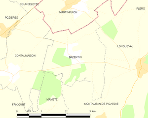
Bazentin
- commune in Somme, France
- Country:
- Postal Code: 80300
- Coordinates: 50° 1' 49" N, 2° 45' 47" E
- GPS tracks (wikiloc): [Link]
- Area: 5.1 sq km
- Population: 79
- Web site: [Link]

Auchonvillers
- commune in Somme, France
- Country:
- Postal Code: 80560
- Coordinates: 50° 4' 51" N, 2° 37' 48" E
- GPS tracks (wikiloc): [Link]
- Area: 5.72 sq km
- Population: 138


Authuille
- commune in Somme, France
- Country:
- Postal Code: 80300
- Coordinates: 50° 2' 35" N, 2° 40' 6" E
- GPS tracks (wikiloc): [Link]
- Area: 3.58 sq km
- Population: 170
- Web site: [Link]


Ovillers-la-Boisselle
- commune in Somme, France
- Country:
- Postal Code: 80300
- Coordinates: 50° 1' 53" N, 2° 41' 52" E
- GPS tracks (wikiloc): [Link]
- AboveSeaLevel: 115 м m
- Area: 9.61 sq km
- Population: 448
- Web site: [Link]


Pozières
- commune in Somme, France
- Country:
- Postal Code: 80300
- Coordinates: 50° 2' 27" N, 2° 43' 22" E
- GPS tracks (wikiloc): [Link]
- Area: 3.24 sq km
- Population: 259
- Web site: [Link]


Contalmaison
- commune in Somme, France
- Country:
- Postal Code: 80300
- Coordinates: 50° 1' 23" N, 2° 43' 49" E
- GPS tracks (wikiloc): [Link]
- Area: 5.67 sq km
- Population: 119
- Web site: [Link]


Courcelette
- commune in Somme, France
- Country:
- Postal Code: 80300
- Coordinates: 50° 3' 30" N, 2° 44' 49" E
- GPS tracks (wikiloc): [Link]
- Area: 4.66 sq km
- Population: 151
- Web site: [Link]


Dernancourt
- commune in Somme, France
- Country:
- Postal Code: 80300
- Coordinates: 49° 58' 27" N, 2° 37' 51" E
- GPS tracks (wikiloc): [Link]
- Area: 6.63 sq km
- Population: 504
- Web site: [Link]


Laviéville
- commune in Somme, France
- Country:
- Postal Code: 80300
- Coordinates: 49° 59' 28" N, 2° 34' 33" E
- GPS tracks (wikiloc): [Link]
- Area: 2.15 sq km
- Population: 172
- Web site: [Link]


Beaumont-Hamel
- commune in Somme, France
- Country:
- Postal Code: 80300
- Coordinates: 50° 5' 1" N, 2° 39' 23" E
- GPS tracks (wikiloc): [Link]
- Area: 8.31 sq km
- Population: 211


Thiepval
- commune in Somme, France
- Country:
- Postal Code: 80300
- Coordinates: 50° 3' 16" N, 2° 41' 20" E
- GPS tracks (wikiloc): [Link]
- Area: 4.4 sq km
- Population: 131
- Web site: [Link]