canton of Anet (canton d'Anet)

- canton of France
- Country:

- Capital: Anet
- Coordinates: 48° 49' 24" N, 1° 29' 12" E


- GPS tracks (wikiloc): [Link]
- Population: 24704
- Wikipedia en: wiki(en)
- Wikipedia: wiki(fr)
- Wikidata storage: Wikidata: Q1504611
- INSEE canton code: [2801]
Includes regions:
Havelu
- commune in Eure-et-Loir, France
- Country:
- Postal Code: 28410
- Coordinates: 48° 47' 15" N, 1° 32' 2" E
- GPS tracks (wikiloc): [Link]
- Area: 3.7 sq km
- Population: 135


Berchères-sur-Vesgre
- commune in Eure-et-Loir, France
- Country:
- Postal Code: 28560
- Coordinates: 48° 50' 28" N, 1° 32' 26" E
- GPS tracks (wikiloc): [Link]
- Area: 11.99 sq km
- Population: 832
- Web site: [Link]
Champagne
- former commune in Eure-et-Loir, France
- Country:
- Postal Code: 28410
- Coordinates: 48° 45' 48" N, 1° 34' 11" E
- GPS tracks (wikiloc): [Link]
- Area: 2.21 sq km
- Population: 311

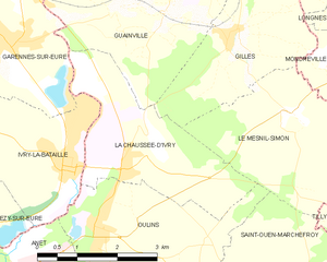
La Chaussée-d'Ivry
- commune in Eure-et-Loir, France
- Country:
- Postal Code: 28260
- Coordinates: 48° 52' 56" N, 1° 28' 45" E
- GPS tracks (wikiloc): [Link]
- Area: 8.39 sq km
- Population: 1099
- Web site: [Link]

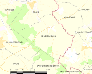
Le Mesnil-Simon
- commune in Eure-et-Loir, France
- Country:
- Postal Code: 28260
- Coordinates: 48° 53' 46" N, 1° 32' 13" E
- GPS tracks (wikiloc): [Link]
- Area: 9.17 sq km
- Population: 605
- Web site: [Link]

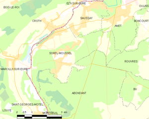
Sorel-Moussel
- commune in Eure-et-Loir, France
- Country:
- Postal Code: 28520
- Coordinates: 48° 50' 28" N, 1° 22' 55" E
- GPS tracks (wikiloc): [Link]
- Area: 12.8 sq km
- Population: 1798
- Web site: [Link]
Saint-Ouen-Marchefroy
- commune in Eure-et-Loir, France
- Country:
- Postal Code: 28560
- Coordinates: 48° 51' 28" N, 1° 31' 57" E
- GPS tracks (wikiloc): [Link]
- Area: 9.21 sq km
- Population: 292
- Web site: [Link]


Guainville
- commune in Eure-et-Loir, France
- Country:
- Postal Code: 28260
- Coordinates: 48° 54' 54" N, 1° 29' 31" E
- GPS tracks (wikiloc): [Link]
- Area: 14.12 sq km
- Population: 725


Abondant
- commune in Eure-et-Loir, France
- Country:
- Postal Code: 28570
- Coordinates: 48° 47' 5" N, 1° 26' 21" E
- GPS tracks (wikiloc): [Link]
- Area: 34.8 sq km
- Population: 2320

Gilles
- commune in Eure-et-Loir, France
- Country:
- Postal Code: 28260
- Coordinates: 48° 54' 50" N, 1° 30' 52" E
- GPS tracks (wikiloc): [Link]
- Area: 7.26 sq km
- Population: 535
- Web site: [Link]


Marchezais
- commune in Eure-et-Loir, France
- Country:
- Postal Code: 28410
- Coordinates: 48° 46' 20" N, 1° 30' 30" E
- GPS tracks (wikiloc): [Link]
- Area: 2.19 sq km
- Population: 309
- Web site: [Link]
Goussainville
- former commune in Eure-et-Loir, France
- Country:
- Postal Code: 28410
- Coordinates: 48° 46' 35" N, 1° 33' 16" E
- GPS tracks (wikiloc): [Link]
- Area: 10.83 sq km
- Population: 965


Anet
- commune in Eure-et-Loir, France
- Country:
- Postal Code: 28260
- Coordinates: 48° 51' 18" N, 1° 26' 22" E
- GPS tracks (wikiloc): [Link]
- Area: 7.85 sq km
- Population: 2690
- Web site: [Link]


Saint-Lubin-de-la-Haye
- commune in Eure-et-Loir, France
- Country:
- Postal Code: 28410
- Coordinates: 48° 49' 9" N, 1° 34' 17" E
- GPS tracks (wikiloc): [Link]
- Area: 14.32 sq km
- Population: 953
- Web site: [Link]

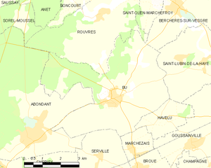
Bû
- commune in Eure-et-Loir, France
- Country:
- Postal Code: 28410
- Coordinates: 48° 47' 47" N, 1° 29' 43" E
- GPS tracks (wikiloc): [Link]
- Area: 22.6 sq km
- Population: 1926
- Web site: [Link]


Rouvres
- commune in Eure-et-Loir, France
- Country:
- Postal Code: 28260
- Coordinates: 48° 50' 22" N, 1° 29' 5" E
- GPS tracks (wikiloc): [Link]
- AboveSeaLevel: 72 м m
- Area: 16.24 sq km
- Population: 794

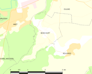
Boncourt
- commune in Eure-et-Loir, France
- Country:
- Postal Code: 28260
- Coordinates: 48° 50' 48" N, 1° 27' 40" E
- GPS tracks (wikiloc): [Link]
- Area: 3.71 sq km
- Population: 268
Saussay
- commune in Eure-et-Loir, France
- Country:
- Postal Code: 28260
- Coordinates: 48° 51' 25" N, 1° 24' 31" E
- GPS tracks (wikiloc): [Link]
- Area: 4.59 sq km
- Population: 1075
- Web site: [Link]


Oulins
- commune in Eure-et-Loir, France
- Country:
- Postal Code: 28260
- Coordinates: 48° 51' 55" N, 1° 28' 15" E
- GPS tracks (wikiloc): [Link]
- Area: 10.08 sq km
- Population: 1193
Serville
- commune in Eure-et-Loir, France
- Country:
- Postal Code: 28410
- Coordinates: 48° 46' 8" N, 1° 29' 7" E
- GPS tracks (wikiloc): [Link]
- Area: 5.62 sq km
- Population: 360
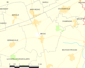
Broué
- commune in Eure-et-Loir, France
- Country:
- Postal Code: 28410
- Coordinates: 48° 44' 54" N, 1° 31' 19" E
- GPS tracks (wikiloc): [Link]
- Area: 12.03 sq km
- Population: 890
- Web site: [Link]