canton of Beaucaire (canton de Beaucaire)

- canton of France
- Country:

- Capital: Beaucaire
- Coordinates: 43° 48' 0" N, 4° 38' 0" E


- GPS tracks (wikiloc): [Link]
- Population: 36795
- Wikipedia en: wiki(en)
- Wikipedia: wiki(fr)
- Wikidata storage: Wikidata: Q239308
- Wikipedia Commons Category: [Link]
- Library of Congress authority ID: Alt: [n87903476]
- INSEE canton code: [3006]
Includes regions:


Beaucaire
- commune in Gard, France
- Country:
- Postal Code: 30300
- Coordinates: 43° 48' 26" N, 4° 38' 36" E
- GPS tracks (wikiloc): [Link]
- Area: 86.52 sq km
- Population: 16094


Fourques
- commune in Gard, France
- Country:
- Postal Code: 30300
- Coordinates: 43° 41' 35" N, 4° 36' 38" E
- GPS tracks (wikiloc): [Link]
- AboveSeaLevel: 3 м m
- Area: 38.24 sq km
- Population: 2880
- Web site: [Link]

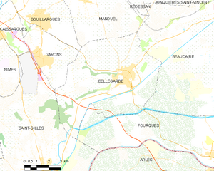
Bellegarde
- commune in Gard, France
- Country:
- Postal Code: 30127
- Coordinates: 43° 45' 13" N, 4° 30' 52" E
- GPS tracks (wikiloc): [Link]
- Area: 44.96 sq km
- Population: 6847

Jonquières-Saint-Vincent
- commune in Gard, France
- Country:
- Postal Code: 30300
- Coordinates: 43° 49' 41" N, 4° 33' 48" E
- GPS tracks (wikiloc): [Link]
- AboveSeaLevel: 42 м m
- Area: 21.32 sq km
- Population: 3687
- Web site: [Link]


Vallabrègues
- commune in Gard, France
- Country:
- Postal Code: 30300
- Coordinates: 43° 51' 11" N, 4° 37' 39" E
- GPS tracks (wikiloc): [Link]
- Area: 14.33 sq km
- Population: 1379