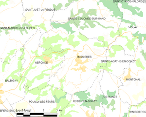
canton of Néronde (canton de Néronde)
- canton of France
- Country:

- Capital: Néronde
- Coordinates: 45° 51' 28" N, 4° 14' 22" E


- GPS tracks (wikiloc): [Link]
- Wikipedia en: wiki(en)
- Wikipedia: wiki(fr)
- Wikidata storage: Wikidata: Q1677834
- Library of Congress authority ID: Alt: [n90676028]
- INSEE canton code: [4210]
Includes regions:


Saint-Marcel-de-Félines
- commune in Loire, France
- Country:
- Postal Code: 42122
- Coordinates: 45° 52' 6" N, 4° 11' 29" E
- GPS tracks (wikiloc): [Link]
- Area: 22.43 sq km
- Population: 826
- Web site: [Link]


Sainte-Colombe-sur-Gand
- commune in Loire, France
- Country:
- Postal Code: 42540
- Coordinates: 45° 52' 44" N, 4° 16' 30" E
- GPS tracks (wikiloc): [Link]
- Area: 13.56 sq km
- Population: 427
- Web site: [Link]


Pinay
- commune in Loire, France
- Country:
- Postal Code: 42590
- Coordinates: 45° 52' 24" N, 4° 8' 14" E
- GPS tracks (wikiloc): [Link]
- Area: 6.62 sq km
- Population: 277

Bussières
- commune in Loire, France
- Country:
- Postal Code: 42510
- Coordinates: 45° 50' 15" N, 4° 16' 6" E
- GPS tracks (wikiloc): [Link]
- Area: 16.76 sq km
- Population: 1576
- Web site: [Link]


Balbigny
- commune in Loire, France
- Country:
- Postal Code: 42510
- Coordinates: 45° 49' 5" N, 4° 11' 14" E
- GPS tracks (wikiloc): [Link]
- Area: 16.98 sq km
- Population: 2989
- Web site: [Link]


Violay
- commune in Loire, France
- Country:
- Postal Code: 42780
- Coordinates: 45° 51' 11" N, 4° 21' 29" E
- GPS tracks (wikiloc): [Link]
- Area: 27.07 sq km
- Population: 1238


Sainte-Agathe-en-Donzy
- commune in Loire, France
- Country:
- Postal Code: 42510
- Coordinates: 45° 50' 16" N, 4° 18' 26" E
- GPS tracks (wikiloc): [Link]
- Area: 3.39 sq km
- Population: 125


Saint-Jodard
- commune in Loire, France
- Country:
- Postal Code: 42590
- Coordinates: 45° 52' 50" N, 4° 7' 56" E
- GPS tracks (wikiloc): [Link]
- Area: 6.65 sq km
- Population: 454