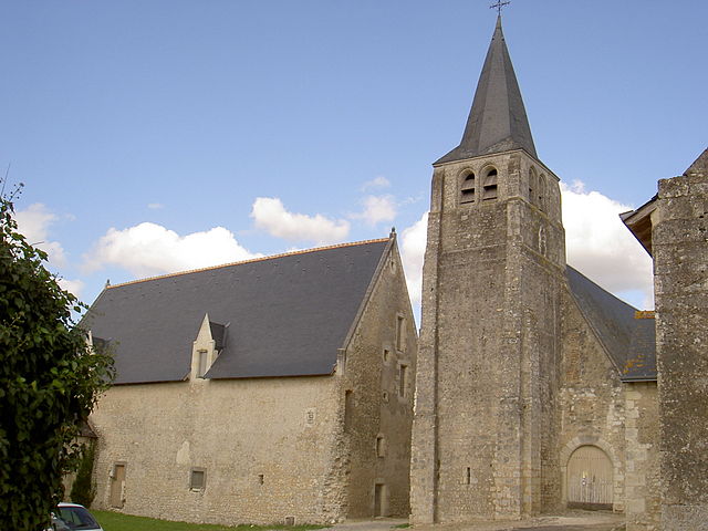
Sainte-Maure-de-Touraine (Sainte-Maure-de-Touraine)

- commune in Indre-et-Loire, France
- Country:

- Postal Code: 37800
- Coordinates: 47° 6' 44" N, 0° 37' 16" E


- GPS tracks (wikiloc): [Link]
- Area: 40.41 sq km
- Population: 4351
- Web site: http://www.sainte-maure-de-touraine.fr
- Wikipedia en: wiki(en)
- Wikipedia: wiki(fr)
- Wikidata storage: Wikidata: Q474524
- Wikipedia Commons Category: [Link]
- Freebase ID: [/m/03nvdkn]
- GeoNames ID: Alt: [6433117]
- SIREN number: [213702269]
- BnF ID: [152577763]
- VIAF ID: Alt: [133962818]
- Library of Congress authority ID: Alt: [no2007100556]
- PACTOLS thesaurus ID: [pcrtM4rmtzPP5J]
- INSEE municipality code: 37226
Shares border with regions:


Draché
- commune in Indre-et-Loire, France
- Country:
- Postal Code: 37800
- Coordinates: 47° 3' 18" N, 0° 37' 27" E
- GPS tracks (wikiloc): [Link]
- Area: 18.51 sq km
- Population: 736
- Web site: [Link]


Sainte-Catherine-de-Fierbois
- commune in Indre-et-Loire, France
- Country:
- Postal Code: 37800
- Coordinates: 47° 9' 27" N, 0° 39' 13" E
- GPS tracks (wikiloc): [Link]
- Area: 15.49 sq km
- Population: 747
- Web site: [Link]


Bossée
- commune in Indre-et-Loire, France
- Country:
- Postal Code: 37240
- Coordinates: 47° 6' 43" N, 0° 43' 44" E
- GPS tracks (wikiloc): [Link]
- Area: 19.01 sq km
- Population: 334

Le Louroux
- commune in Indre-et-Loire, France
- Country:
- Postal Code: 37240
- Coordinates: 47° 9' 38" N, 0° 47' 11" E
- GPS tracks (wikiloc): [Link]
- Area: 28.87 sq km
- Population: 520
- Web site: [Link]


Pouzay
- commune in Indre-et-Loire, France
- Country:
- Postal Code: 37800
- Coordinates: 47° 4' 55" N, 0° 32' 3" E
- GPS tracks (wikiloc): [Link]
- Area: 14.07 sq km
- Population: 845


Maillé
- commune in Indre-et-Loire, France
- Country:
- Postal Code: 37800
- Coordinates: 47° 3' 10" N, 0° 34' 53" E
- GPS tracks (wikiloc): [Link]
- Area: 15.67 sq km
- Population: 580
- Web site: [Link]

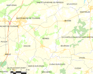
Sepmes
- commune in Indre-et-Loire, France
- Country:
- Postal Code: 37800
- Coordinates: 47° 4' 5" N, 0° 40' 24" E
- GPS tracks (wikiloc): [Link]
- Area: 28.59 sq km
- Population: 643
- Web site: [Link]


Saint-Épain
- commune in Indre-et-Loire, France
- Country:
- Postal Code: 37800
- Coordinates: 47° 8' 43" N, 0° 32' 13" E
- GPS tracks (wikiloc): [Link]
- Area: 62.65 sq km
- Population: 1563
- Web site: [Link]

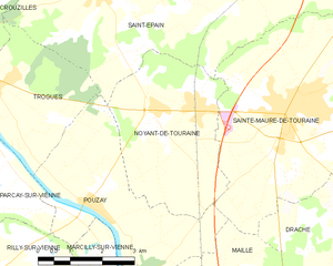
Noyant-de-Touraine
- commune in Indre-et-Loire, France
- Country:
- Postal Code: 37800
- Coordinates: 47° 6' 34" N, 0° 33' 33" E
- GPS tracks (wikiloc): [Link]
- Area: 13.74 sq km
- Population: 1206
- Web site: [Link]