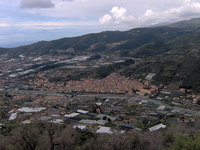
Castellaro (Castellaro)
.svg)
- Italian comune
 Hiking in Castellaro
Castellaro is a beautiful destination for hiking, located in the Italian region of Liguria, near the coast. The area offers diverse landscapes, from rolling hills to scenic coastal views, making it a great spot for both novice and experienced hikers. Here are some highlights and tips for hiking in Castellaro:
Trails and Routes:
-
Coastal Trails: Many trails along the coastline provide stunning views of the Mediterranean Sea. These paths often feature varying degrees of difficulty, suitable for hikers of all levels.
-
Hills and Countryside: The inland areas of Castellaro offer trails through vineyards, olive groves, and rustic villages. These paths often lead to panoramic viewpoints, perfect for taking a break and enjoying the scenery.
-
Nature Reserves: There are several protected areas nearby, such as the Monte Carlo area, where you can find well-marked trails that showcase local flora and fauna.
Best Time to Hike:
- Spring (March to May): The weather is mild, and wildflowers are in bloom. This is an ideal time for hiking as trails are less crowded.
- Autumn (September to November): Enjoy pleasant temperatures and harvest season, perfect for exploring rural trails.
Preparation Tips:
- Footwear: Wear sturdy hiking boots to navigate rocky and uneven terrain comfortably.
- Water and Snacks: Carry enough water and pack some snacks to stay energized during your hike.
- Map and GPS: Having a map or a GPS device is essential, as some trails may not be well-marked.
Local Regulations:
- Always follow local hiking guidelines and respect the natural environment. Stick to marked trails to minimize your impact on wildlife and vegetation.
Cultural and Historical Sites:
While hiking in Castellaro, take the opportunity to explore the local culture. You may pass historic sites, charming villages, and local vineyards. Don’t hesitate to stop and enjoy the local cuisine at nearby trattorias.
Safety:
- Always inform someone of your hiking plans and expected return time.
- Check the weather forecast before heading out, and prepare accordingly.
Whether you’re looking for a peaceful hike through nature or an adventure with breathtaking views, Castellaro has something to offer. Happy hiking!
- Country:

- Postal Code: 18011
- Local Dialing Code: 0184
- Licence Plate Code: IM
- Coordinates: 43° 51' 52" N, 7° 52' 8" E


- GPS tracks (wikiloc): [Link]
- AboveSeaLevel: 275 м m
- Area: 7.86 sq km
- Population: 1268
- Web site: http://www.comune.castellazzobormida.al.it
- Wikipedia en: wiki(en)
- Wikipedia: wiki(it)
- Wikidata storage: Wikidata: Q260657
- Wikipedia Commons Category: [Link]
- Freebase ID: [/m/0gbych]
- GeoNames ID: Alt: [6539609]
- OSM relation ID: [42689]
- ISTAT ID: 008014
- Italian cadastre code: C143
Shares border with regions:


Pietrabruna
- Italian comune
Hiking in Pietrabruna
Pietrabruna is a picturesque village located in the province of Imperia in the Italian region of Liguria. Nestled in the hills above the coastline, it offers stunning views and a variety of hiking opportunities that cater to different skill levels. Here are some key points about hiking in Pietrabruna:...
- Country:
- Postal Code: 18010
- Local Dialing Code: 0183
- Licence Plate Code: IM
- Coordinates: 43° 53' 23" N, 7° 54' 12" E
- GPS tracks (wikiloc): [Link]
- AboveSeaLevel: 400 м m
- Area: 10.22 sq km
- Population: 472
- Web site: [Link]


Pompeiana
- Italian comune
Hiking in Pompeiana
Pompeiana is a charming village located in the Liguria region of Italy, near the Italian Riviera. It offers a unique hiking experience with its stunning coastal views, picturesque landscapes, and rich history. Here are some highlights of hiking in and around Pompeiana:...
- Country:
- Postal Code: 18015
- Local Dialing Code: 0184
- Licence Plate Code: IM
- Coordinates: 43° 51' 12" N, 7° 53' 19" E
- GPS tracks (wikiloc): [Link]
- AboveSeaLevel: 200 м m
- Area: 5.38 sq km
- Population: 842
- Web site: [Link]


Riva Ligure
- Italian comune
Hiking in Riva Ligure
Riva Ligure is a charming coastal village located in the province of Imperia in the Liguria region of Italy. It offers a beautiful setting for hiking, characterized by stunning views of the Mediterranean Sea, lush olive groves, and picturesque landscapes. Here are some key points about hiking in Riva Ligure:...
- Country:
- Postal Code: 18015
- Local Dialing Code: 0184
- Licence Plate Code: IM
- Coordinates: 43° 50' 15" N, 7° 52' 55" E
- GPS tracks (wikiloc): [Link]
- AboveSeaLevel: 2 м m
- Area: 2.07 sq km
- Population: 2878
- Web site: [Link]

Taggia
- Italian comune
Hiking in Taggia
Taggia is a charming town located in the Liguria region of Italy, known for its rich history, traditional olive production, and beautiful landscapes. Hiking around Taggia offers a variety of trails that cater to different skill levels, displaying the stunning scenery of the Italian Riviera, hills, and valleys....
- Country:
- Postal Code: 18018
- Local Dialing Code: 0184
- Licence Plate Code: IM
- Coordinates: 43° 50' 38" N, 7° 51' 3" E
- GPS tracks (wikiloc): [Link]
- AboveSeaLevel: 39 м m
- Area: 31.36 sq km
- Population: 14003
- Web site: [Link]