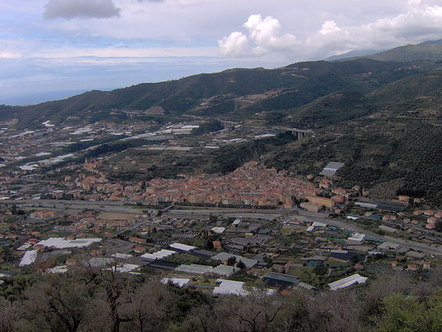
Pietrabruna (Pietrabruna)
.svg)
- Italian comune
 Hiking in Pietrabruna
Pietrabruna is a picturesque village located in the province of Imperia in the Italian region of Liguria. Nestled in the hills above the coastline, it offers stunning views and a variety of hiking opportunities that cater to different skill levels. Here are some key points about hiking in Pietrabruna:
Trails and Terrain
- Coastal Views: Many trails in the area offer breathtaking views of the Ligurian Sea, with panoramic vistas of the coastline.
- Diverse Pathways: The terrain varies from gentle slopes to more challenging ascents, allowing hikers of all abilities to find suitable routes.
- Historic Trails: You can explore ancient paths that have been used for centuries, often leading to old farmhouses or offering connections to the local fauna and flora.
Natural Environment
- Mediterranean Vegetation: The trails are adorned with typical Mediterranean vegetation, including olive groves, chestnut trees, and wild herbs.
- Wildlife Spotting: The area is rich in biodiversity, so keep an eye out for various bird species and other wildlife, particularly in the more secluded areas.
Recommended Hikes
- Pietrabruna to San Lorenzo al Mare: A moderate trail that offers beautiful views of the coastline and is a great way to enjoy the local landscape.
- Monte Faudo: For those looking for a more challenging hike, hiking up to Monte Faudo provides rewarding views of the surrounding area and the sea.
Preparation and Tips
- Footwear: Wear sturdy hiking shoes with good traction, as some trails can be rocky and steep.
- Water and Snacks: Carry enough water and some snacks; not all trails have amenities along the way.
- Weather Check: The weather in Liguria can change quickly, so check the forecast before heading out.
Local Insights
- Cultural Experience: Enjoy the local culture by visiting the village, trying regional cuisine, and meeting the friendly locals.
- Guided Tours: If you’re unfamiliar with the area or want to discover hidden gems, consider joining a guided hiking tour to learn more about the local ecology and culture.
Hiking in Pietrabruna can be a delightful experience, combining natural beauty, physical activity, and cultural exploration. Enjoy your adventure!
- Country:

- Postal Code: 18010
- Local Dialing Code: 0183
- Licence Plate Code: IM
- Coordinates: 43° 53' 23" N, 7° 54' 12" E


- GPS tracks (wikiloc): [Link]
- AboveSeaLevel: 400 м m
- Area: 10.22 sq km
- Population: 472
- Web site: http://www.comunepietrabruna.it/
- Wikipedia en: wiki(en)
- Wikipedia: wiki(it)
- Wikidata storage: Wikidata: Q269489
- Wikipedia Commons Category: [Link]
- Freebase ID: [/m/0gbyxh]
- GeoNames ID: Alt: [6537043]
- VIAF ID: Alt: [235266908]
- OSM relation ID: [42718]
- TGN ID: [7050582]
- ISTAT ID: 008041
- Italian cadastre code: G607
Shares border with regions:


Castellaro
- Italian comune
Hiking in Castellaro
Castellaro is a beautiful destination for hiking, located in the Italian region of Liguria, near the coast. The area offers diverse landscapes, from rolling hills to scenic coastal views, making it a great spot for both novice and experienced hikers. Here are some highlights and tips for hiking in Castellaro:...
- Country:
- Postal Code: 18011
- Local Dialing Code: 0184
- Licence Plate Code: IM
- Coordinates: 43° 51' 52" N, 7° 52' 8" E
- GPS tracks (wikiloc): [Link]
- AboveSeaLevel: 275 м m
- Area: 7.86 sq km
- Population: 1268
- Web site: [Link]


Cipressa
- Italian comune
Hiking in Cipressa
Cipressa is a charming town located in the province of Imperia in the Liguria region of Italy. It’s situated along the beautiful Italian Riviera, which offers stunning coastal views and a pleasant Mediterranean climate. Hiking in the area around Cipressa provides a fantastic opportunity to explore scenic landscapes, traditional villages, and the breathtaking coastline. Here are some highlights and tips for hiking in and around Cipressa:...
- Country:
- Postal Code: 18017
- Local Dialing Code: 0183
- Licence Plate Code: IM
- Coordinates: 43° 51' 5" N, 7° 55' 50" E
- GPS tracks (wikiloc): [Link]
- AboveSeaLevel: 240 м m
- Area: 9.39 sq km
- Population: 1272
- Web site: [Link]


Civezza
- Italian comune
Hiking in Civezza
Civezza is a charming village located in the Italian region of Liguria, near the coast and not far from the well-known town of San Remo. The area around Civezza is characterized by its beautiful landscapes, olive groves, and scenic views of the Mediterranean Sea, making it a fantastic destination for hiking enthusiasts....
- Country:
- Postal Code: 18017
- Local Dialing Code: 0183
- Licence Plate Code: IM
- Coordinates: 43° 52' 46" N, 7° 57' 4" E
- GPS tracks (wikiloc): [Link]
- AboveSeaLevel: 222 м m
- Area: 3.88 sq km
- Population: 599
- Web site: [Link]


Dolcedo
- Italian comune
Hiking in Dolcedo
Dolcedo, a charming village located in the Italian Riviera region of Liguria, offers a great backdrop for hiking enthusiasts. Nestled in a picturesque valley, surrounded by ancient olive groves and Mediterranean vegetation, Dolcedo provides an array of hiking trails that cater to various skill levels....
- Country:
- Postal Code: 18020
- Local Dialing Code: 0183
- Licence Plate Code: IM
- Coordinates: 43° 54' 25" N, 7° 57' 6" E
- GPS tracks (wikiloc): [Link]
- AboveSeaLevel: 75 м m
- Area: 19.8 sq km
- Population: 1385
- Web site: [Link]


Pompeiana
- Italian comune
Hiking in Pompeiana
Pompeiana is a charming village located in the Liguria region of Italy, near the Italian Riviera. It offers a unique hiking experience with its stunning coastal views, picturesque landscapes, and rich history. Here are some highlights of hiking in and around Pompeiana:...
- Country:
- Postal Code: 18015
- Local Dialing Code: 0184
- Licence Plate Code: IM
- Coordinates: 43° 51' 12" N, 7° 53' 19" E
- GPS tracks (wikiloc): [Link]
- AboveSeaLevel: 200 м m
- Area: 5.38 sq km
- Population: 842
- Web site: [Link]

Taggia
- Italian comune
Hiking in Taggia
Taggia is a charming town located in the Liguria region of Italy, known for its rich history, traditional olive production, and beautiful landscapes. Hiking around Taggia offers a variety of trails that cater to different skill levels, displaying the stunning scenery of the Italian Riviera, hills, and valleys....
- Country:
- Postal Code: 18018
- Local Dialing Code: 0184
- Licence Plate Code: IM
- Coordinates: 43° 50' 38" N, 7° 51' 3" E
- GPS tracks (wikiloc): [Link]
- AboveSeaLevel: 39 м m
- Area: 31.36 sq km
- Population: 14003
- Web site: [Link]