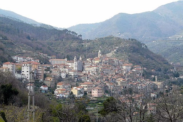
Taggia (Taggia)
.svg)
- Italian comune
 Hiking in Taggia
Taggia is a charming town located in the Liguria region of Italy, known for its rich history, traditional olive production, and beautiful landscapes. Hiking around Taggia offers a variety of trails that cater to different skill levels, displaying the stunning scenery of the Italian Riviera, hills, and valleys.
Here are some highlights for hiking in Taggia:
Trail Options:
-
Via dei Muli:
- This ancient mule track connects Taggia with the nearby town of San Remo. The trail is relatively easy and offers beautiful views of the coastline and the surrounding hills.
-
Monte Bignone:
- A more challenging hike that leads to the top of Monte Bignone, which stands at about 1,000 meters. The panoramic views from the summit are truly rewarding.
-
Taggia to Ospedaletti:
- This scenic route follows the coastline and includes sections through charming villages. It's a moderate hike, perfect for enjoying both nature and local culture.
-
Riviera dei Fiori:
- A longer trail that can be followed along the coastline, showcasing the “Flower Riviera.” It’s suitable for those who enjoy walking beside the sea with plenty of opportunities to explore small beaches and coves.
Tips for Hiking in Taggia:
- Season: Spring and autumn are usually the best times for hiking in this region, as the weather is mild, and the landscapes are particularly beautiful.
- Gear: Wear sturdy hiking boots and bring plenty of water, snacks, and sunscreen, as some trails may lack shade.
- Navigation: Some trails may not be well-marked, so it's a good idea to carry a map or a GPS device.
- Local Guidance: Consider joining local hiking groups or guided tours to learn more about the area and enhance your hiking experience.
Other Activities:
Besides hiking, Taggia offers opportunities for cultural exploration, including historic churches and olive mills where you can learn about traditional olive oil production. The town’s vibrant markets and local cuisine, especially its Ligurian specialties, are also worth experiencing after a day on the trails.
Overall, hiking in Taggia provides a fantastic way to appreciate the natural beauty and rich cultural heritage of the Italian Riviera!
- Country:

- Postal Code: 18018
- Local Dialing Code: 0184
- Licence Plate Code: IM
- Coordinates: 43° 50' 38" N, 7° 51' 3" E


- GPS tracks (wikiloc): [Link]
- AboveSeaLevel: 39 м m
- Area: 31.36 sq km
- Population: 14003
- Web site: http://www.taggia.it/
- Wikipedia en: wiki(en)
- Wikipedia: wiki(it)
- Wikidata storage: Wikidata: Q269823
- Wikipedia Commons Category: [Link]
- Freebase ID: [/m/0gbz6b]
- GeoNames ID: Alt: [6542051]
- VIAF ID: Alt: [146739106]
- OSM relation ID: [42668]
- MusicBrainz area ID: [372f74db-c626-472b-b3ba-5ed2f646fd97]
- UN/LOCODE: [ITTGA]
- Digital Atlas of the Roman Empire ID: [44321]
- ISTAT ID: 008059
- Italian cadastre code: L024
Shares border with regions:


Castellaro
- Italian comune
Hiking in Castellaro
Castellaro is a beautiful destination for hiking, located in the Italian region of Liguria, near the coast. The area offers diverse landscapes, from rolling hills to scenic coastal views, making it a great spot for both novice and experienced hikers. Here are some highlights and tips for hiking in Castellaro:...
- Country:
- Postal Code: 18011
- Local Dialing Code: 0184
- Licence Plate Code: IM
- Coordinates: 43° 51' 52" N, 7° 52' 8" E
- GPS tracks (wikiloc): [Link]
- AboveSeaLevel: 275 м m
- Area: 7.86 sq km
- Population: 1268
- Web site: [Link]


Badalucco
- Italian comune
Hiking in Badalucco
Badalucco is a charming village located in the province of Imperia, in the Liguria region of Italy. Nestled in the foothills of the Alps, it offers a number of hiking opportunities that provide stunning views of the surrounding mountains and the nearby coastline....
- Country:
- Postal Code: 18010
- Local Dialing Code: 0184
- Licence Plate Code: IM
- Coordinates: 43° 54' 57" N, 7° 50' 49" E
- GPS tracks (wikiloc): [Link]
- AboveSeaLevel: 179 м m
- Area: 16.1 sq km
- Population: 1123
- Web site: [Link]

Ceriana
- Italian comune
Hiking in Ceriana
Ceriana is a charming medieval village located in the Italian region of Liguria, not far from the beautiful Ligurian coast and the Riviera dei Fiori. The area boasts stunning landscapes, with rolling hills, olive groves, and panoramic views of the surrounding countryside and the sea. Here are some key highlights for hiking in and around Ceriana:...
- Country:
- Postal Code: 18034
- Local Dialing Code: 0184
- Licence Plate Code: IM
- Coordinates: 43° 52' 45" N, 7° 46' 29" E
- GPS tracks (wikiloc): [Link]
- AboveSeaLevel: 369 м m
- Area: 31.79 sq km
- Population: 1214
- Web site: [Link]


Dolcedo
- Italian comune
Hiking in Dolcedo
Dolcedo, a charming village located in the Italian Riviera region of Liguria, offers a great backdrop for hiking enthusiasts. Nestled in a picturesque valley, surrounded by ancient olive groves and Mediterranean vegetation, Dolcedo provides an array of hiking trails that cater to various skill levels....
- Country:
- Postal Code: 18020
- Local Dialing Code: 0183
- Licence Plate Code: IM
- Coordinates: 43° 54' 25" N, 7° 57' 6" E
- GPS tracks (wikiloc): [Link]
- AboveSeaLevel: 75 м m
- Area: 19.8 sq km
- Population: 1385
- Web site: [Link]


Pietrabruna
- Italian comune
Hiking in Pietrabruna
Pietrabruna is a picturesque village located in the province of Imperia in the Italian region of Liguria. Nestled in the hills above the coastline, it offers stunning views and a variety of hiking opportunities that cater to different skill levels. Here are some key points about hiking in Pietrabruna:...
- Country:
- Postal Code: 18010
- Local Dialing Code: 0183
- Licence Plate Code: IM
- Coordinates: 43° 53' 23" N, 7° 54' 12" E
- GPS tracks (wikiloc): [Link]
- AboveSeaLevel: 400 м m
- Area: 10.22 sq km
- Population: 472
- Web site: [Link]


Riva Ligure
- Italian comune
Hiking in Riva Ligure
Riva Ligure is a charming coastal village located in the province of Imperia in the Liguria region of Italy. It offers a beautiful setting for hiking, characterized by stunning views of the Mediterranean Sea, lush olive groves, and picturesque landscapes. Here are some key points about hiking in Riva Ligure:...
- Country:
- Postal Code: 18015
- Local Dialing Code: 0184
- Licence Plate Code: IM
- Coordinates: 43° 50' 15" N, 7° 52' 55" E
- GPS tracks (wikiloc): [Link]
- AboveSeaLevel: 2 м m
- Area: 2.07 sq km
- Population: 2878
- Web site: [Link]


Sanremo
- Italian comune
Hiking in Sanremo
Sanremo, located on the Italian Riviera in the region of Liguria, is well-known for its beautiful landscapes, mild climate, and stunning coastal views. Hiking in and around Sanremo offers a wonderful opportunity to explore the natural beauty of the area, from the Mediterranean coast to the surrounding hills and mountains. Here are some highlights and tips for hiking in Sanremo:...
- Country:
- Postal Code: 18038
- Local Dialing Code: 0184
- Licence Plate Code: IM
- Coordinates: 43° 49' 17" N, 7° 47' 12" E
- GPS tracks (wikiloc): [Link]
- AboveSeaLevel: 15 м m
- Area: 55.96 sq km
- Population: 54824
- Web site: [Link]