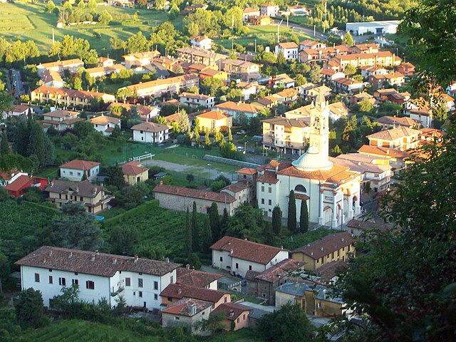
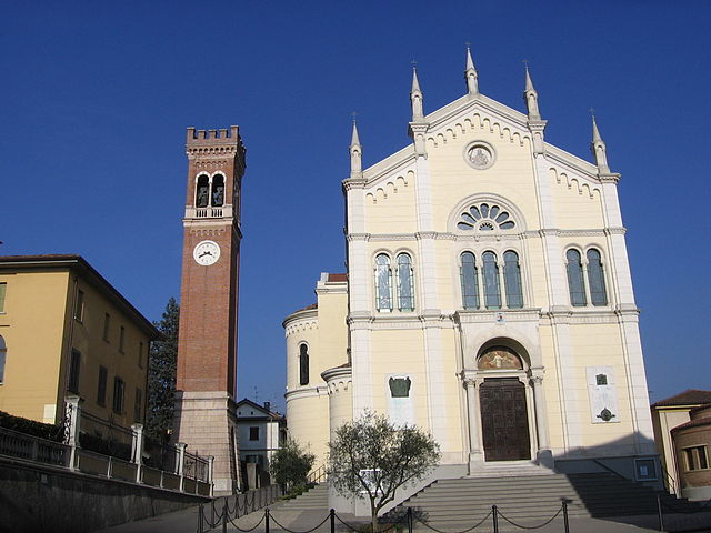
Cenate Sotto (Cenate Sotto)
.svg)
- Italian comune
 Hiking in Cenate Sotto
Cenate Sotto is a charming town located in the province of Bergamo in Lombardy, Italy. It's surrounded by beautiful landscapes, making it an excellent destination for hiking enthusiasts. Here’s a brief overview of what you can expect when hiking in this area:
Trails and Landscapes
-
Varied Terrain: The area around Cenate Sotto features a mix of rolling hills, forests, and panoramic views of the surrounding mountains, including the nearby Bergamasque Alps.
-
Local Trails: There are various established trails that cater to different skill levels. Some popular routes include:
- Sentiero dei Santi: This trail connects several small chapels and offers beautiful views of the valley. It's well-marked and suitable for various skill levels.
- Fossa del Cielo: A more challenging hike that takes you through dense woods and offers stunning scenery, perfect for more experienced hikers.
-
Natural Parks: You can easily access trails that lead into the nearby regional parks, such as the Parco dei Colli di Bergamo, which provide extensive options for hiking in a protected natural environment.
Best Time to Hike
- Spring and Fall: The best times to hike in Cenate Sotto are during the spring (April to June) and fall (September to October) when the weather is mild and the landscapes are vibrant.
- Summer: Be prepared for warmer temperatures and sun exposure. Early morning hikes can be more comfortable.
What to Bring
- Footwear: Wear sturdy hiking shoes with good traction, especially if you opt for more rugged trails.
- Water and Snacks: Always carry enough water and snacks to stay hydrated and energized.
- Map/GPS: While many trails are marked, it’s advisable to have a map or GPS device to avoid getting lost.
Additional Tips
- Local Guides: Consider hiring a local guide or joining a hiking group for an enriching experience, as they can provide insights about the area’s flora, fauna, and history.
- Respect Nature: Follow Leave No Trace principles to help preserve the natural beauty of the area.
- Wildlife: Be aware of local wildlife and enjoy observing them from a distance.
Enjoy your hiking adventure in Cenate Sotto! The combination of cultural heritage and stunning natural scenery makes it a rewarding experience.
- Country:

- Postal Code: 24069
- Local Dialing Code: 035
- Licence Plate Code: BG
- Coordinates: 45° 42' 0" N, 9° 49' 0" E


- GPS tracks (wikiloc): [Link]
- AboveSeaLevel: 267 м m
- Area: 4.62 sq km
- Population: 3825
- Web site: http://www.comune.cenatesotto.bg.it/
- Wikipedia en: wiki(en)
- Wikipedia: wiki(it)
- Wikidata storage: Wikidata: Q100347
- Wikipedia Commons Gallery: [Link]
- Wikipedia Commons Category: [Link]
- Freebase ID: [/m/0gj9m3]
- GeoNames ID: Alt: [6542556]
- OSM relation ID: [45816]
- UN/LOCODE: [ITSOT]
- ISTAT ID: 016069
- Italian cadastre code: C457
Shares border with regions:


Cenate Sopra
- Italian comune
Hiking in Cenate Sopra
Cenate Sopra is a picturesque town located in the province of Bergamo in Lombardy, Italy. It sits at the foothills of the Pre-Alps, making it an attractive base for hikers and nature enthusiasts. The area offers a variety of trails that cater to different skill levels, from leisurely walks to more challenging treks....
- Country:
- Postal Code: 24060
- Local Dialing Code: 035
- Licence Plate Code: BG
- Coordinates: 45° 42' 42" N, 9° 49' 20" E
- GPS tracks (wikiloc): [Link]
- AboveSeaLevel: 330 м m
- Area: 6.97 sq km
- Population: 2571
- Web site: [Link]


San Paolo d'Argon
- Italian comune
Hiking in San Paolo d'Argon
San Paolo d'Argon, located in the province of Bergamo in northern Italy, offers a variety of hiking opportunities amidst beautiful landscapes. The region is characterized by its rolling hills, vineyards, and scenic views of the surrounding valleys and mountains, including the nearby Orobian Alps....
- Country:
- Postal Code: 24060
- Local Dialing Code: 035
- Licence Plate Code: BG
- Coordinates: 45° 41' 21" N, 9° 48' 11" E
- GPS tracks (wikiloc): [Link]
- AboveSeaLevel: 255 м m
- Area: 5.25 sq km
- Population: 5725
- Web site: [Link]

Scanzorosciate
- Italian comune
Hiking in Scanzorosciate
Scanzorosciate is a charming town located in the Lombardy region of northern Italy, near the city of Bergamo. The area offers a variety of hiking opportunities that allow you to explore its stunning landscapes, nature, and cultural heritage....
- Country:
- Postal Code: 24020
- Local Dialing Code: 035
- Licence Plate Code: BG
- Coordinates: 45° 42' 41" N, 9° 44' 9" E
- GPS tracks (wikiloc): [Link]
- AboveSeaLevel: 297 м m
- Area: 10.69 sq km
- Population: 10076
- Web site: [Link]

Torre de' Roveri
- Italian comune
Hiking in Torre de' Roveri
Torre de' Roveri is a charming town located in the province of Bergamo, Lombardy, Italy. It's surrounded by beautiful landscapes, making it a great spot for hiking enthusiasts. Here are some highlights and tips for hiking in and around Torre de' Roveri:...
- Country:
- Postal Code: 24060
- Local Dialing Code: 035
- Licence Plate Code: BG
- Coordinates: 45° 42' 0" N, 9° 46' 20" E
- GPS tracks (wikiloc): [Link]
- AboveSeaLevel: 271 м m
- Area: 2.69 sq km
- Population: 2470
- Web site: [Link]


Trescore Balneario
- Italian comune
Hiking in Trescore Balneario
Trescore Balneario, located in the province of Bergamo in northern Italy, is a charming town known for its thermal baths and scenic landscapes. While it's not as widely recognized for hiking as some other areas in the Italian Alps, it can serve as a great base for exploring nearby trails and natural attractions....
- Country:
- Postal Code: 24069
- Local Dialing Code: 035
- Licence Plate Code: BG
- Coordinates: 45° 42' 0" N, 9° 51' 0" E
- GPS tracks (wikiloc): [Link]
- AboveSeaLevel: 271 м m
- Area: 13.51 sq km
- Population: 9814
- Web site: [Link]