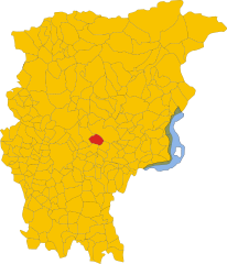
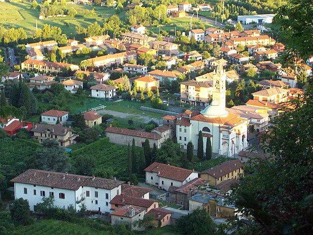
Cenate Sopra (Cenate Sopra)
.svg)
- Italian comune
 Hiking in Cenate Sopra
Cenate Sopra is a picturesque town located in the province of Bergamo in Lombardy, Italy. It sits at the foothills of the Pre-Alps, making it an attractive base for hikers and nature enthusiasts. The area offers a variety of trails that cater to different skill levels, from leisurely walks to more challenging treks.
Popular Hiking Trails in and Around Cenate Sopra:
-
Sentiero dei Ghetti: This is a relatively easy trail that offers stunning views of the surrounding landscape. It is suitable for families and provides a pleasant hiking experience amidst nature.
-
Monte Misma: A moderate hike leads you to Monte Misma, which stands at an elevation of 1,381 meters. The trail winds through lush forests and opens up to breathtaking panoramic views from the summit.
-
Sentiero dei Galli: This trail is more challenging and involves some elevation gain. It provides an excellent opportunity to explore the local flora and fauna, and hikers can enjoy secluded spots along the way.
-
Parco dei Colli di Bergamo: This regional park is nearby and offers numerous trails that explore the hills around Bergamo. It's a great option for those looking to embark on longer hikes or to connect with nature.
Hiking Tips:
- Weather: Always check the weather forecast before heading out, as conditions can change quickly in mountainous regions.
- Gear: Wear comfortable hiking shoes and bring plenty of water, snacks, and a map or guidebook. Depending on the trail, you may also want trekking poles.
- Respect Nature: Stay on marked trails, take all litter with you, and respect the local wildlife.
- Local Regulations: Make sure to check any local regulations or guidelines regarding hiking in the area.
Conclusion:
Hiking in Cenate Sopra offers a wonderful experience for outdoor lovers, combining stunning natural beauty with a rich cultural backdrop. Whether you're seeking a gentle walk or a more ambitious hike, Cenate Sopra provides a great escape into the tranquil Italian countryside.
- Country:

- Postal Code: 24060
- Local Dialing Code: 035
- Licence Plate Code: BG
- Coordinates: 45° 42' 42" N, 9° 49' 20" E


- GPS tracks (wikiloc): [Link]
- AboveSeaLevel: 330 м m
- Area: 6.97 sq km
- Population: 2571
- Web site: http://www.comune.cenatesopra.bg.it
- Wikipedia en: wiki(en)
- Wikipedia: wiki(it)
- Wikidata storage: Wikidata: Q100199
- Wikipedia Commons Gallery: [Link]
- Wikipedia Commons Category: [Link]
- Freebase ID: [/m/0gj9lr]
- GeoNames ID: Alt: [6542555]
- VIAF ID: Alt: [241224583]
- OSM relation ID: [45857]
- ISTAT ID: 016068
- Italian cadastre code: C456
Shares border with regions:


Cenate Sotto
- Italian comune
Hiking in Cenate Sotto
Cenate Sotto is a charming town located in the province of Bergamo in Lombardy, Italy. It's surrounded by beautiful landscapes, making it an excellent destination for hiking enthusiasts. Here’s a brief overview of what you can expect when hiking in this area:...
- Country:
- Postal Code: 24069
- Local Dialing Code: 035
- Licence Plate Code: BG
- Coordinates: 45° 42' 0" N, 9° 49' 0" E
- GPS tracks (wikiloc): [Link]
- AboveSeaLevel: 267 м m
- Area: 4.62 sq km
- Population: 3825
- Web site: [Link]

Pradalunga
- Italian comune
Hiking in Pradalunga
Pradalunga, located in the Lombardy region of Italy, offers a beautiful area for hiking enthusiasts. Nestled in the hills near Bergamo, it features a mix of scenic landscapes, charming villages, and lush nature. Here’s what you can expect when hiking in this area:...
- Country:
- Postal Code: 24020
- Local Dialing Code: 035
- Licence Plate Code: BG
- Coordinates: 45° 44' 48" N, 9° 46' 59" E
- GPS tracks (wikiloc): [Link]
- AboveSeaLevel: 327 м m
- Area: 8.2 sq km
- Population: 4674
- Web site: [Link]

Scanzorosciate
- Italian comune
Hiking in Scanzorosciate
Scanzorosciate is a charming town located in the Lombardy region of northern Italy, near the city of Bergamo. The area offers a variety of hiking opportunities that allow you to explore its stunning landscapes, nature, and cultural heritage....
- Country:
- Postal Code: 24020
- Local Dialing Code: 035
- Licence Plate Code: BG
- Coordinates: 45° 42' 41" N, 9° 44' 9" E
- GPS tracks (wikiloc): [Link]
- AboveSeaLevel: 297 м m
- Area: 10.69 sq km
- Population: 10076
- Web site: [Link]


Trescore Balneario
- Italian comune
Hiking in Trescore Balneario
Trescore Balneario, located in the province of Bergamo in northern Italy, is a charming town known for its thermal baths and scenic landscapes. While it's not as widely recognized for hiking as some other areas in the Italian Alps, it can serve as a great base for exploring nearby trails and natural attractions....
- Country:
- Postal Code: 24069
- Local Dialing Code: 035
- Licence Plate Code: BG
- Coordinates: 45° 42' 0" N, 9° 51' 0" E
- GPS tracks (wikiloc): [Link]
- AboveSeaLevel: 271 м m
- Area: 13.51 sq km
- Population: 9814
- Web site: [Link]


Albino, Lombardy
- Italian comune
Hiking in Albino, Lombardy
Albino, located in the Lombardy region of Italy, is a charming town nestled in the foothills of the Bergamasque Alps. The area offers a variety of hiking opportunities, making it a great destination for outdoor enthusiasts....
- Country:
- Postal Code: 24021
- Local Dialing Code: 035
- Licence Plate Code: BG
- Coordinates: 45° 45' 38" N, 9° 47' 49" E
- GPS tracks (wikiloc): [Link]
- AboveSeaLevel: 342 м m
- Area: 31.81 sq km
- Population: 17903
- Web site: [Link]