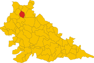
Ceresara (Ceresara)
.svg)
- Italian comune
 Hiking in Ceresara
Ceresara is a charming village located in the Lombardy region of Italy, near the banks of the Po River. While it may not be as well-known as some of Italy’s more famous hiking destinations, the surrounding areas offer a variety of trails and natural landscapes for outdoor enthusiasts to explore.
Hiking Opportunities in Ceresara:
-
Lombardy Countryside: The trails around Ceresara often flow through picturesque farmland, vineyards, and small woodlands. You can enjoy walking through the serene landscape, taking in views of rolling hills and traditional Italian architecture.
-
Parco del Mincio: This park is a short drive from Ceresara and offers a network of trails along the Mincio River. It is a great place to go hiking and enjoy nature, with opportunities for bird watching and observing local flora and fauna.
-
Monte Guglielmo: While a bit further away, this mountain offers more challenging hikes with stunning panoramic views of the surrounding landscape. Ideal for hikers looking for a more strenuous experience, you can find various paths that lead to the summit.
-
Biking and Walking Trails: The area around Ceresara is also suitable for biking, with several trails that connect to nearby towns. This can be a great way to explore the countryside if you’re looking for a mix of hiking and cycling.
Tips for Hiking in Ceresara:
- Research Trails: Before you head out, check local maps or hiking apps for information on trail conditions and difficulty levels.
- Stay Hydrated: Carry enough water and snacks, especially on longer hikes.
- Wear Appropriate Footwear: Sturdy hiking boots or shoes are recommended for better grip and comfort.
- Respect Nature: Always follow local guidelines to protect the environment and keep wildlife safe.
Best Time to Hike:
Spring and autumn are the ideal seasons for hiking in this region, as the weather is generally mild and the landscapes are often vibrant with colors. Summer can be hot and humid, so early morning hikes are advisable.
In summary, hiking in and around Ceresara can provide a delightful experience for those looking to explore the Italian countryside away from the usual tourist spots. Enjoy your hike!
- Country:

- Postal Code: 46040
- Local Dialing Code: 0376
- Licence Plate Code: MN
- Coordinates: 45° 15' 44" N, 10° 34' 10" E


- GPS tracks (wikiloc): [Link]
- AboveSeaLevel: 44 м m
- Area: 37.31 sq km
- Population: 2609
- Web site: http://www.comune.ceresara.mn.it/
- Wikipedia en: wiki(en)
- Wikipedia: wiki(it)
- Wikidata storage: Wikidata: Q42342
- Wikipedia Commons Category: [Link]
- Freebase ID: [/m/0gj_yb]
- GeoNames ID: Alt: [6540373]
- VIAF ID: Alt: [245852851]
- OSM relation ID: [44465]
- UN/LOCODE: [ITESA]
- ISTAT ID: 020019
- Italian cadastre code: C502
Shares border with regions:


Casaloldo
- Italian comune
Hiking in Casaloldo
Casaloldo, a small town in the Lombardy region of Italy, may not be widely recognized for its hiking trails, but it offers a picturesque landscape typical of the northern Italian countryside. While specific hiking trails in Casaloldo itself might be limited, there are opportunities for outdoor activities in the surrounding areas, especially in the provinces of Mantua and Brescia....
- Country:
- Postal Code: 46040
- Local Dialing Code: 0376
- Licence Plate Code: MN
- Coordinates: 45° 15' 0" N, 10° 29' 0" E
- GPS tracks (wikiloc): [Link]
- AboveSeaLevel: 45 м m
- Area: 16.85 sq km
- Population: 2699
- Web site: [Link]


Rodigo
- Italian comune
Hiking in Rodigo
Rodigo is a small town in the Lombardy region of Italy, known for its historical architecture and charming countryside. While it's not a major hiking destination like the nearby Alps or National Parks, there are still opportunities for hiking and enjoying nature in the surrounding areas....
- Country:
- Postal Code: 46040
- Local Dialing Code: 0376
- Licence Plate Code: MN
- Coordinates: 45° 12' 0" N, 10° 38' 0" E
- GPS tracks (wikiloc): [Link]
- AboveSeaLevel: 31 м m
- Area: 41.61 sq km
- Population: 5272
- Web site: [Link]


Piubega
- Italian comune
Hiking in Piubega
Piubega is a small municipality located in the Lombardy region of Italy, near Lake Garda and the surrounding hills. While it may not be as well-known as some of Italy's bigger tourist destinations, it offers a quaint atmosphere and natural beauty that can be appealing for hiking enthusiasts looking for off-the-beaten-path experiences....
- Country:
- Postal Code: 46040
- Local Dialing Code: 0376
- Licence Plate Code: MN
- Coordinates: 45° 14' 0" N, 10° 32' 0" E
- GPS tracks (wikiloc): [Link]
- AboveSeaLevel: 40 м m
- Area: 16.59 sq km
- Population: 1681
- Web site: [Link]
Guidizzolo
- Italian comune
Hiking in Guidizzolo
Guidizzolo is a small town located in the Lombardy region of Italy, near Mantua. While it might not be a well-known hiking destination like the Dolomites or Lake Como, there are still opportunities to explore the beautiful countryside around the area....
- Country:
- Postal Code: 46040
- Local Dialing Code: 0376
- Licence Plate Code: MN
- Coordinates: 45° 19' 0" N, 10° 35' 0" E
- GPS tracks (wikiloc): [Link]
- AboveSeaLevel: 46 м m
- Area: 22.38 sq km
- Population: 6013
- Web site: [Link]


Medole
- Italian comune
Hiking in Medole
Medole is located in the Lombardy region of Italy, known for its picturesque landscapes and proximity to various outdoor activities, including hiking. While Medole itself may not be a major hiking destination, its surrounding area offers a variety of trails and natural settings that are great for hikers....
- Country:
- Postal Code: 46046
- Local Dialing Code: 0376
- Licence Plate Code: MN
- Coordinates: 45° 20' 0" N, 10° 31' 0" E
- GPS tracks (wikiloc): [Link]
- AboveSeaLevel: 62 м m
- Area: 25.73 sq km
- Population: 4055
- Web site: [Link]


Gazoldo degli Ippoliti
- Italian comune
Hiking in Gazoldo degli Ippoliti
Gazoldo degli Ippoliti is a charming town in the Lombardy region of Italy, surrounded by a picturesque landscape ideal for hiking. While the town itself might not be a major hiking destination, the surrounding countryside offers beautiful trails and scenic routes that are perfect for outdoor enthusiasts....
- Country:
- Postal Code: 46040
- Local Dialing Code: 0376
- Licence Plate Code: MN
- Coordinates: 45° 12' 0" N, 10° 35' 0" E
- GPS tracks (wikiloc): [Link]
- AboveSeaLevel: 35 м m
- Area: 13.03 sq km
- Population: 2970
- Web site: [Link]


Goito
- Italian comune
Hiking in Goito
Goito is a charming municipality located in the Lombardy region of northern Italy. While it is not as well-known for hiking as some of the more prominent regions in Italy (like the Dolomites or the Aosta Valley), there are still opportunities for outdoor enthusiasts to explore the natural beauty of the area....
- Country:
- Postal Code: 46044
- Local Dialing Code: 0376
- Licence Plate Code: MN
- Coordinates: 45° 15' 0" N, 10° 40' 0" E
- GPS tracks (wikiloc): [Link]
- AboveSeaLevel: 33 м m
- Area: 79.22 sq km
- Population: 10222
- Web site: [Link]


Castel Goffredo
- Italian comune
Hiking in Castel Goffredo
Castel Goffredo, located in the Lombardy region of Italy, is not as widely recognized for hiking as some other mountainous areas, but it offers a charming landscape and opportunities for outdoor activities. The region is primarily agricultural, characterized by rolling hills, vineyards, and small bodies of water, providing a serene backdrop for hiking enthusiasts....
- Country:
- Postal Code: 46042
- Local Dialing Code: 0376
- Licence Plate Code: MN
- Coordinates: 45° 17' 52" N, 10° 28' 30" E
- GPS tracks (wikiloc): [Link]
- AboveSeaLevel: 50 м m
- Area: 42.4 sq km
- Population: 12633
- Web site: [Link]