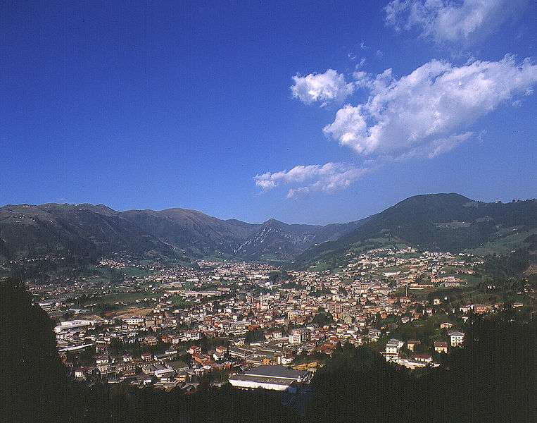
Cerete (Cerete)
.svg)
- Italian comune
 Hiking in Cerete
Cerete, located in the province of Brescia in northern Italy, offers a scenic backdrop for hiking enthusiasts. This area is characterized by its beautiful landscapes, charming villages, and Mediterranean climate, making it an attractive destination for outdoor activities, including hiking.
Hiking Trails
-
Lake Iseo Trails: Nearby Lake Iseo is a fantastic location for hiking, with several trails ranging from easy walks along the lake shore to more challenging routes leading into the surrounding hills. The Sentiero del Vino, for instance, offers a scenic path through vineyard-covered hills.
-
Franciacorta Region: This area is known for its vineyards and rolling hills. Several hiking paths weave through picturesque villages and vineyards, allowing hikers to enjoy stunning views and perhaps a wine tasting along the way.
-
Monte Guglielmo: A prominent peak near Cerete that provides more challenging hikes. The trails vary in length and difficulty, but the summit offers breathtaking panoramic views of the surrounding valleys and lakes.
Best Time to Hike
- Spring (April to June): Flowers are blooming, and temperatures are mild.
- Fall (September to October): The weather is still pleasant, and you can enjoy the autumn foliage.
What to Bring
- Comfortable Footwear: Hiking boots with good grip are essential.
- Water and Snacks: Stay hydrated and have energy-boosting snacks on hand.
- Weather-Appropriate Clothing: Layers are advisable, as temperatures can vary significantly.
- Map or GPS Device: Familiarize yourself with the trails and don’t rely solely on mobile signal.
Safety Considerations
- Always check the weather forecast before heading out.
- Let someone know your hiking plans, especially if you are hiking in remote areas.
- Be aware of your skill level and choose hikes that match your fitness and experience.
Local Culture
While hiking, take time to appreciate the local culture and cuisine. Stopping in a small village for a meal or tasting some local wines can enhance your experience in this beautiful region.
Whether you're a novice or a seasoned hiker, Cerete and its surroundings have something to offer everyone. Enjoy the natural beauty and the unique landscapes of this charming part of Italy!
- Country:

- Postal Code: 24020
- Local Dialing Code: 0346
- Licence Plate Code: BG
- Coordinates: 45° 52' 0" N, 10° 3' 0" E


- GPS tracks (wikiloc): [Link]
- AboveSeaLevel: 612 м m
- Area: 14.07 sq km
- Population: 1597
- Web site: http://www.comune.cerete.bg.it
- Wikipedia en: wiki(en)
- Wikipedia: wiki(it)
- Wikidata storage: Wikidata: Q100358
- Wikipedia Commons Gallery: [Link]
- Wikipedia Commons Category: [Link]
- Freebase ID: [/m/0gj9p7]
- GeoNames ID: Alt: [6536143]
- VIAF ID: Alt: [236991517]
- OSM relation ID: [46290]
- MusicBrainz area ID: [52767da9-898d-4043-9389-bd6e853c6ee1]
- UN/LOCODE: [ITERT]
- ISTAT ID: 016071
- Italian cadastre code: C506
Shares border with regions:

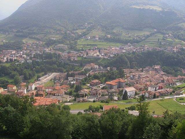
Gandino
- Italian comune
Hiking in Gandino
Gandino is a charming village located in the province of Bergamo, Lombardy, Italy. Nestled in the Seriana Valley and surrounded by stunning mountain landscapes, it offers a variety of hiking opportunities for outdoor enthusiasts. Here are some key aspects to consider when hiking in Gandino:...
- Country:
- Postal Code: 24024
- Local Dialing Code: 035
- Licence Plate Code: BG
- Coordinates: 45° 48' 42" N, 9° 54' 11" E
- GPS tracks (wikiloc): [Link]
- AboveSeaLevel: 553 м m
- Area: 29.03 sq km
- Population: 5390
- Web site: [Link]


Rovetta
- Italian comune
Hiking in Rovetta
Rovetta, located in the Bergamasque Alps of northern Italy, offers a fantastic hiking experience due to its stunning landscapes, charming village atmosphere, and variety of trails suited for different skill levels....
- Country:
- Postal Code: 24020
- Local Dialing Code: 0346
- Coordinates: 45° 53' 0" N, 9° 59' 0" E
- GPS tracks (wikiloc): [Link]
- AboveSeaLevel: 650 м m
- Area: 24.53 sq km
- Population: 4168
- Web site: [Link]


Songavazzo
- Italian comune
Hiking in Songavazzo
Songavazzo is a picturesque village located in the province of Bergamo in the Lombardy region of northern Italy. It's nestled in the valleys of the Orobie Alps and is known for its beautiful natural landscapes, traditional architecture, and rich history. Hiking in and around Songavazzo offers a variety of trails suitable for different skill levels, allowing you to enjoy the stunning scenery of the Italian mountains....
- Country:
- Postal Code: 24020
- Local Dialing Code: 0346
- Licence Plate Code: BG
- Coordinates: 45° 53' 0" N, 9° 59' 0" E
- GPS tracks (wikiloc): [Link]
- AboveSeaLevel: 640 м m
- Area: 12.94 sq km
- Population: 706
- Web site: [Link]

Sovere
- Italian comune
Hiking in Sovere
Sovere, located in the Province of Bergamo in northern Italy, is surrounded by beautiful landscapes and offers a variety of hiking opportunities. Nestled in the foothills of the Alps and near Lake Iseo, the area features diverse terrain ranging from gentle hills to more challenging mountain trails....
- Country:
- Postal Code: 24060
- Local Dialing Code: 035
- Licence Plate Code: BG
- Coordinates: 45° 49' 0" N, 10° 2' 0" E
- GPS tracks (wikiloc): [Link]
- AboveSeaLevel: 479 м m
- Area: 18.02 sq km
- Population: 5319
- Web site: [Link]


Bossico
- Italian comune
Hiking in Bossico
Bossico is a charming village located in the Province of Bergamo in northern Italy. It sits at an elevation of about 900 meters (approximately 2,950 feet) above sea level, offering stunning panoramic views of Lake Iseo and the surrounding mountains. Hiking in Bossico allows you to experience the beauty of the Italian Alps, charming landscapes, and rich flora and fauna....
- Country:
- Postal Code: 24060
- Local Dialing Code: 035
- Licence Plate Code: BG
- Coordinates: 45° 49' 39" N, 10° 2' 41" E
- GPS tracks (wikiloc): [Link]
- AboveSeaLevel: 865 м m
- Area: 7.09 sq km
- Population: 993
- Web site: [Link]