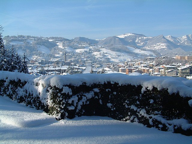
Gandino (Gandino)
.svg)
- Italian comune
 Hiking in Gandino
Gandino is a charming village located in the province of Bergamo, Lombardy, Italy. Nestled in the Seriana Valley and surrounded by stunning mountain landscapes, it offers a variety of hiking opportunities for outdoor enthusiasts. Here are some key aspects to consider when hiking in Gandino:
Trails and Routes
-
Sentiero dei Muri Ancestrali (Path of Ancestral Walls): This scenic route is well-marked and takes you through ancient terraced landscapes, offering views of the village and surrounding mountains.
-
Monte Misma: A popular hike that leads you to summit Monte Misma, which offers spectacular panoramic views of the surrounding valleys and peaks.
-
Parco Regionale delle Orobie Bergamasche: Just a short distance away, this regional park has a vast network of trails suitable for both beginners and experienced hikers, featuring diverse flora and fauna.
Difficulty Levels
- Easy: Many trails around Gandino are family-friendly and suitable for beginners, often with gentle elevations.
- Medium: There are moderate trails that offer a bit more of a challenge and reward hikers with incredible vistas.
- Challenging: For experienced hikers, the steeper trails and higher altitudes around the nearby mountains will provide a fulfilling adventure.
Best Time to Hike
- Spring (April to June): Wildflowers bloom and temperatures are pleasantly mild.
- Summer (July to August): Ideal for hiking, though it can get crowded; be sure to carry sufficient water.
- Autumn (September to October): The changing colors of the leaves create beautiful landscapes, making it a great time for photography.
- Winter (November to March): Some trails may be covered in snow; check local conditions and be prepared for winter hiking if you choose to go.
Safety Tips
- Equipment: Wear sturdy hiking boots, and consider trekking poles for steep or uneven terrain.
- Navigation: Use a map, GPS, or a hiking app to keep track of your route, as some trails may not be well-marked.
- Weather: Check the local weather forecast before heading out and be prepared for quick changes in mountain weather.
Local Culture
Gandino is also rich in history and local culture, so it’s worth exploring the village after your hikes. Don’t miss local culinary delicacies and the warm hospitality of the locals.
Overall, hiking in Gandino provides a perfect combination of nature, challenge, and cultural experience, making it an excellent choice for those looking to explore the Italian Alps.
- Country:

- Postal Code: 24024
- Local Dialing Code: 035
- Licence Plate Code: BG
- Coordinates: 45° 48' 42" N, 9° 54' 11" E


- GPS tracks (wikiloc): [Link]
- AboveSeaLevel: 553 м m
- Area: 29.03 sq km
- Population: 5390
- Web site: http://www.gandino.it
- Wikipedia en: wiki(en)
- Wikipedia: wiki(it)
- Wikidata storage: Wikidata: Q101112
- Wikipedia Commons Gallery: [Link]
- Wikipedia Commons Category: [Link]
- Freebase ID: [/m/0gjbdp]
- GeoNames ID: Alt: [6540596]
- VIAF ID: Alt: [123314093]
- OSM relation ID: [46185]
- archINFORM location ID: [14555]
- MusicBrainz area ID: [8abd207b-6744-44f8-9e34-2053eeb0f1ae]
- WOEID: [715997]
- UN/LOCODE: [ITGND]
- ISTAT ID: 016108
- Italian cadastre code: D905
Shares border with regions:


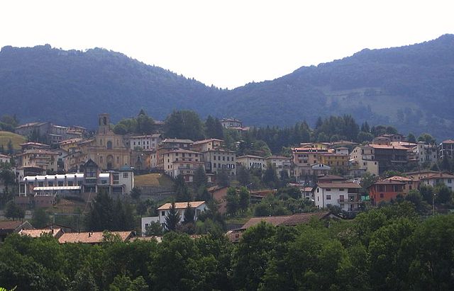
Casnigo
- Italian comune
Hiking in Casnigo
Casnigo is a charming town located in the province of Bergamo, in the Lombardy region of northern Italy. Nestled within the Seriana Valley, it boasts stunning natural scenery, making it an excellent spot for hiking enthusiasts. Here are some key highlights for hiking in and around Casnigo:...
- Country:
- Postal Code: 24020
- Local Dialing Code: 035
- Licence Plate Code: BG
- Coordinates: 45° 48' 59" N, 9° 52' 0" E
- GPS tracks (wikiloc): [Link]
- AboveSeaLevel: 514 м m
- Area: 13.62 sq km
- Population: 3221
- Web site: [Link]


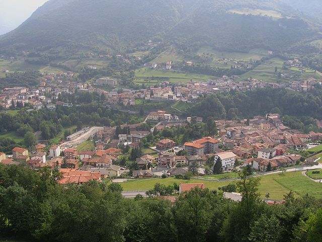
Cazzano Sant'Andrea
- Italian comune
Hiking in Cazzano Sant'Andrea
Cazzano Sant'Andrea is a picturesque village located in the province of Bergamo, in the Lombardy region of Italy. This area is known for its natural beauty, rolling hills, and mountainous terrain, making it a wonderful destination for hiking enthusiasts....
- Country:
- Postal Code: 24026
- Local Dialing Code: 035
- Licence Plate Code: BG
- Coordinates: 45° 49' 0" N, 9° 53' 0" E
- GPS tracks (wikiloc): [Link]
- AboveSeaLevel: 504 м m
- Area: 2.02 sq km
- Population: 1670
- Web site: [Link]


Cerete
- Italian comune
Hiking in Cerete
Cerete, located in the province of Brescia in northern Italy, offers a scenic backdrop for hiking enthusiasts. This area is characterized by its beautiful landscapes, charming villages, and Mediterranean climate, making it an attractive destination for outdoor activities, including hiking....
- Country:
- Postal Code: 24020
- Local Dialing Code: 0346
- Licence Plate Code: BG
- Coordinates: 45° 52' 0" N, 10° 3' 0" E
- GPS tracks (wikiloc): [Link]
- AboveSeaLevel: 612 м m
- Area: 14.07 sq km
- Population: 1597
- Web site: [Link]


Clusone
- town and commune in Lombardy, Italy
Hiking in Clusone
Clusone is a charming town located in the Italian Alps, within the province of Bergamo in Lombardy. It's a wonderful area for hiking, offering a mix of scenic beauty, cultural landmarks, and varying levels of trails suitable for different experience levels....
- Country:
- Postal Code: 24023
- Local Dialing Code: 0346
- Licence Plate Code: BG
- Coordinates: 45° 53' 0" N, 9° 57' 0" E
- GPS tracks (wikiloc): [Link]
- AboveSeaLevel: 647 м m
- Area: 25 sq km
- Population: 8625
- Web site: [Link]


Endine Gaiano
- Italian comune
Hiking in Endine Gaiano
Endine Gaiano is a lovely town located in the province of Bergamo in Italy, situated near the shores of Lake Endine. The area is known for its picturesque landscapes, charming villages, and outdoor recreational opportunities, making it a great destination for hiking enthusiasts....
- Country:
- Postal Code: 24060
- Local Dialing Code: 035
- Licence Plate Code: BG
- Coordinates: 45° 47' 0" N, 9° 58' 0" E
- GPS tracks (wikiloc): [Link]
- AboveSeaLevel: 400 м m
- Area: 21.07 sq km
- Population: 3460
- Web site: [Link]

Leffe, Lombardy
- Italian comune
Hiking in Leffe, Lombardy
Leffe, located in the Lombardy region of northern Italy, is a charming village situated near Lake Iseo and is surrounded by beautiful natural landscapes, making it an excellent spot for hiking enthusiasts. Here are a few highlights and tips for hiking in and around Leffe:...
- Country:
- Postal Code: 24026
- Local Dialing Code: 035
- Licence Plate Code: BG
- Coordinates: 45° 48' 0" N, 9° 54' 0" E
- GPS tracks (wikiloc): [Link]
- AboveSeaLevel: 453 м m
- Area: 6.69 sq km
- Population: 4463
- Web site: [Link]

Peia
- Italian comune
Hiking in Peia
Peia, located in Italy's Lombardy region near Lake Iseo, is a picturesque area that offers a variety of hiking opportunities. Nestled in the foothills of the Alps, the region boasts beautiful landscapes, stunning views, and charming local villages....
- Country:
- Postal Code: 24020
- Local Dialing Code: 035
- Licence Plate Code: BG
- Coordinates: 45° 48' 0" N, 9° 54' 0" E
- GPS tracks (wikiloc): [Link]
- AboveSeaLevel: 570 м m
- Area: 4.48 sq km
- Population: 1818
- Web site: [Link]


Ponte Nossa
- Italian comune
Hiking in Ponte Nossa
Ponte Nossa is a picturesque town located in the Lombardy region of northern Italy, part of the Bergamo province. Surrounded by the stunning Orobie Alps, it offers a variety of hiking opportunities, making it an excellent destination for both novice and experienced hikers....
- Country:
- Postal Code: 24028
- Local Dialing Code: 035
- Licence Plate Code: BG
- Coordinates: 45° 52' 0" N, 9° 53' 0" E
- GPS tracks (wikiloc): [Link]
- AboveSeaLevel: 465 м m
- Area: 5.59 sq km
- Population: 1761
- Web site: [Link]

Ranzanico
- Italian comune
Hiking in Ranzanico
Ranzanico is a small town located in the province of Bergamo in the Lombardy region of Italy. Nestled near the shores of Lake Endine and surrounded by the picturesque landscapes of the Italian Alps, Ranzanico offers various hiking opportunities that cater to different skill levels....
- Country:
- Postal Code: 24060
- Local Dialing Code: 035
- Licence Plate Code: BG
- Coordinates: 45° 47' 0" N, 9° 56' 0" E
- GPS tracks (wikiloc): [Link]
- AboveSeaLevel: 519 м m
- Area: 7.21 sq km
- Population: 1230
- Web site: [Link]


Rovetta
- Italian comune
Hiking in Rovetta
Rovetta, located in the Bergamasque Alps of northern Italy, offers a fantastic hiking experience due to its stunning landscapes, charming village atmosphere, and variety of trails suited for different skill levels....
- Country:
- Postal Code: 24020
- Local Dialing Code: 0346
- Coordinates: 45° 53' 0" N, 9° 59' 0" E
- GPS tracks (wikiloc): [Link]
- AboveSeaLevel: 650 м m
- Area: 24.53 sq km
- Population: 4168
- Web site: [Link]

Sovere
- Italian comune
Hiking in Sovere
Sovere, located in the Province of Bergamo in northern Italy, is surrounded by beautiful landscapes and offers a variety of hiking opportunities. Nestled in the foothills of the Alps and near Lake Iseo, the area features diverse terrain ranging from gentle hills to more challenging mountain trails....
- Country:
- Postal Code: 24060
- Local Dialing Code: 035
- Licence Plate Code: BG
- Coordinates: 45° 49' 0" N, 10° 2' 0" E
- GPS tracks (wikiloc): [Link]
- AboveSeaLevel: 479 м m
- Area: 18.02 sq km
- Population: 5319
- Web site: [Link]