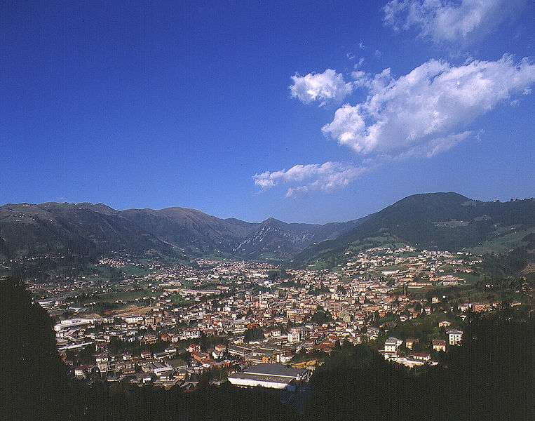
Rovetta (Rovetta)
.svg)
- Italian comune
 Hiking in Rovetta
Rovetta, located in the Bergamasque Alps of northern Italy, offers a fantastic hiking experience due to its stunning landscapes, charming village atmosphere, and variety of trails suited for different skill levels.
Hiking Trails:
-
Sentiero del Val Borlezza: This trail takes you through the beautiful Val Borlezza, characterized by lush vegetation and picturesque views. It's a moderate hike that showcases the natural beauty of the region.
-
Piz de la Cima: A more challenging option, this hike leads to the summit, offering panoramic views of the surrounding mountains and valleys. It requires a good fitness level and proper hiking gear.
-
Sentiero dei Mulini: This easier trail is great for families, as it follows the old mill paths and offers insights into the area's history, along with beautiful scenery.
Tips for Hiking in Rovetta:
- Best Time to Hike: Late spring to early autumn (May to September) is the ideal time for hiking in Rovetta, as the weather is typically mild and the trails are well-maintained.
- Gear: Make sure to wear proper hiking shoes, bring plenty of water, and check the weather conditions before heading out.
- Navigation: While many trails are well-marked, having a map or a GPS device can be helpful, especially on longer or less frequently traveled paths.
- Safety: Always inform someone about your hiking plans, and consider hiking with a partner, especially on more challenging trails.
Amenities:
Rovetta has several local restaurants and shops where you can enjoy traditional Italian cuisine and purchase any hiking supplies you may need. After a day of hiking, you can relax and soak in the local culture and hospitality.
Overall, Rovetta is a beautiful and accessible destination for hikers, whether you're looking for a leisurely stroll or a challenging trek. Enjoy your exploration of this charming alpine region!
- Country:

- Postal Code: 24020
- Local Dialing Code: 0346
- Coordinates: 45° 53' 0" N, 9° 59' 0" E


- GPS tracks (wikiloc): [Link]
- AboveSeaLevel: 650 м m
- Area: 24.53 sq km
- Population: 4168
- Web site: http://www.comune.rovetta.bg.it/
- Wikipedia en: wiki(en)
- Wikipedia: wiki(it)
- Wikidata storage: Wikidata: Q101526
- Wikipedia Commons Gallery: [Link]
- Wikipedia Commons Category: [Link]
- Freebase ID: [/m/0gjdjx]
- GeoNames ID: Alt: [6540599]
- VIAF ID: Alt: [156131431]
- OSM relation ID: [46310]
- archINFORM location ID: [45350]
- UN/LOCODE: [ITRVA]
- ISTAT ID: 016187
- Italian cadastre code: H615
Shares border with regions:


Castione della Presolana
- Italian comune
Hiking in Castione della Presolana
Castione della Presolana, located in the province of Bergamo in northern Italy, is a beautiful destination for hiking enthusiasts. Nestled in the picturesque Italian Alps, it offers stunning landscapes, diverse flora and fauna, and a range of trails suited for various skill levels. Here’s what you need to know about hiking in this charming area:...
- Country:
- Postal Code: 24020
- Local Dialing Code: 0346
- Licence Plate Code: BG
- Coordinates: 45° 54' 0" N, 10° 2' 0" E
- GPS tracks (wikiloc): [Link]
- AboveSeaLevel: 986 м m
- Area: 42.5 sq km
- Population: 3419
- Web site: [Link]


Cerete
- Italian comune
Hiking in Cerete
Cerete, located in the province of Brescia in northern Italy, offers a scenic backdrop for hiking enthusiasts. This area is characterized by its beautiful landscapes, charming villages, and Mediterranean climate, making it an attractive destination for outdoor activities, including hiking....
- Country:
- Postal Code: 24020
- Local Dialing Code: 0346
- Licence Plate Code: BG
- Coordinates: 45° 52' 0" N, 10° 3' 0" E
- GPS tracks (wikiloc): [Link]
- AboveSeaLevel: 612 м m
- Area: 14.07 sq km
- Population: 1597
- Web site: [Link]


Clusone
- town and commune in Lombardy, Italy
Hiking in Clusone
Clusone is a charming town located in the Italian Alps, within the province of Bergamo in Lombardy. It's a wonderful area for hiking, offering a mix of scenic beauty, cultural landmarks, and varying levels of trails suitable for different experience levels....
- Country:
- Postal Code: 24023
- Local Dialing Code: 0346
- Licence Plate Code: BG
- Coordinates: 45° 53' 0" N, 9° 57' 0" E
- GPS tracks (wikiloc): [Link]
- AboveSeaLevel: 647 м m
- Area: 25 sq km
- Population: 8625
- Web site: [Link]


Colere
- place and comune in Lombardy, Italy
Hiking in Colere
Colere is a charming village located in the Italian Alps, specifically in the region of Lombardy. Known for its natural beauty, stunning landscapes, and a variety of hiking trails, it offers a great destination for outdoor enthusiasts. Here are some key highlights and information about hiking in Colere:...
- Country:
- Postal Code: 24020
- Local Dialing Code: 0346
- Licence Plate Code: BG
- Coordinates: 45° 58' 24" N, 10° 4' 50" E
- GPS tracks (wikiloc): [Link]
- AboveSeaLevel: 1013 м m
- Area: 18.63 sq km
- Population: 1122
- Web site: [Link]


Fino del Monte
- Italian comune
Hiking in Fino del Monte
Fino del Monte is a charming destination for hiking enthusiasts, located in the Bergamo area of Lombardy, Italy. Nestled in the Orobie Alps, this quaint village offers stunning landscapes, rich flora and fauna, and a variety of hiking trails that cater to different skill levels....
- Country:
- Postal Code: 24020
- Local Dialing Code: 0346
- Licence Plate Code: BG
- Coordinates: 45° 53' 0" N, 10° 2' 0" E
- GPS tracks (wikiloc): [Link]
- AboveSeaLevel: 662 м m
- Area: 4.29 sq km
- Population: 1142
- Web site: [Link]

Gandino
- Italian comune
Hiking in Gandino
Gandino is a charming village located in the province of Bergamo, Lombardy, Italy. Nestled in the Seriana Valley and surrounded by stunning mountain landscapes, it offers a variety of hiking opportunities for outdoor enthusiasts. Here are some key aspects to consider when hiking in Gandino:...
- Country:
- Postal Code: 24024
- Local Dialing Code: 035
- Licence Plate Code: BG
- Coordinates: 45° 48' 42" N, 9° 54' 11" E
- GPS tracks (wikiloc): [Link]
- AboveSeaLevel: 553 м m
- Area: 29.03 sq km
- Population: 5390
- Web site: [Link]


Oltressenda Alta
- Italian comune
Hiking in Oltressenda Alta
Oltressenda Alta is a beautiful area in the Italian Alps, part of the Bergamo province in Lombardy. This region offers breathtaking landscapes, rich natural beauty, and a variety of hiking options suitable for different skill levels. Here are some highlights and tips for hiking in Oltressenda Alta:...
- Country:
- Postal Code: 24020
- Local Dialing Code: 0346
- Licence Plate Code: BG
- Coordinates: 45° 55' 0" N, 9° 56' 0" E
- GPS tracks (wikiloc): [Link]
- AboveSeaLevel: 714 м m
- Area: 17.33 sq km
- Population: 146
- Web site: [Link]


Piario
- Italian comune
Hiking in Piario
Piario, located in the Lombardy region of Italy, is surrounded by stunning natural landscapes, making it a great destination for hiking enthusiasts. Nestled in the Seriana Valley, the area features a mix of mountainous terrain, wooded areas, and picturesque villages which offer a variety of hiking options suitable for different skill levels....
- Country:
- Postal Code: 24020
- Local Dialing Code: 0346
- Licence Plate Code: BG
- Coordinates: 45° 53' 46" N, 9° 55' 26" E
- GPS tracks (wikiloc): [Link]
- AboveSeaLevel: 539 м m
- Area: 1.55 sq km
- Population: 1074
- Web site: [Link]


Songavazzo
- Italian comune
Hiking in Songavazzo
Songavazzo is a picturesque village located in the province of Bergamo in the Lombardy region of northern Italy. It's nestled in the valleys of the Orobie Alps and is known for its beautiful natural landscapes, traditional architecture, and rich history. Hiking in and around Songavazzo offers a variety of trails suitable for different skill levels, allowing you to enjoy the stunning scenery of the Italian mountains....
- Country:
- Postal Code: 24020
- Local Dialing Code: 0346
- Licence Plate Code: BG
- Coordinates: 45° 53' 0" N, 9° 59' 0" E
- GPS tracks (wikiloc): [Link]
- AboveSeaLevel: 640 м m
- Area: 12.94 sq km
- Population: 706
- Web site: [Link]


Villa d'Ogna
- Italian comune
Hiking in Villa d'Ogna
Villa d'Ogna is a charming village located in the province of Bergamo, Lombardy, Italy. Nestled in the scenic Val Seriana valley, it offers a range of hiking opportunities that allow you to explore the stunning natural landscape of the region....
- Country:
- Postal Code: 24020
- Local Dialing Code: 0346
- Licence Plate Code: BG
- Coordinates: 45° 54' 0" N, 9° 56' 0" E
- GPS tracks (wikiloc): [Link]
- AboveSeaLevel: 542 м m
- Area: 5.16 sq km
- Population: 1869
- Web site: [Link]


Vilminore di Scalve
- Italian comune
Hiking in Vilminore di Scalve
Vilminore di Scalve is a picturesque town located in the Val di Scalve region of Italy, nestled in the Alps of Lombardy. The area is known for its stunning scenic beauty and variety of hiking opportunities, making it an excellent destination for outdoor enthusiasts....
- Country:
- Postal Code: 24020
- Local Dialing Code: 0346
- Licence Plate Code: BG
- Coordinates: 46° 0' 0" N, 10° 6' 0" E
- GPS tracks (wikiloc): [Link]
- AboveSeaLevel: 1019 м m
- Area: 41 sq km
- Population: 1479
- Web site: [Link]