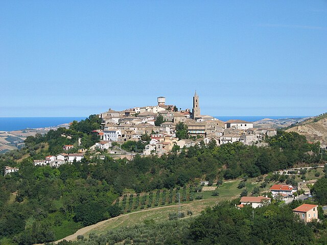
Cermignano (Cermignano)
.svg)
- Italian comune
 Hiking in Cermignano
Cermignano, a charming town located in the Teramo province of Italy, offers a unique blend of natural beauty and cultural heritage. Here are some aspects to consider for hiking in and around Cermignano:
Trail Options
- Local Trails: There are numerous trails that wind through the surrounding hills and countryside, often leading to stunning views of the Monti della Laga and Gran Sasso mountain ranges.
- Sentiero Italia: Part of a long-distance trail that spans the entire Italian peninsula, sections of this trail may pass near Cermignano, offering both challenge and splendid scenery.
- Historic Trails: Some trails connect small villages and historical sites, allowing hikers to explore local history and culture alongside nature.
Difficulty Levels
- Easy to Moderate: Many trails around Cermignano can be suitable for beginners and families, featuring gentle slopes and well-marked paths.
- Challenging Routes: For more experienced hikers, the surrounding mountains provide steeper and more rugged trails.
Natural Highlights
- Flora and Fauna: The region boasts diverse ecosystems, with opportunities to see local wildlife and various plant species.
- Panoramic Views: Look for points along the trails that offer breathtaking views of the surrounding landscapes, especially at sunset.
Best Time to Hike
- Spring and Autumn: These seasons typically offer mild weather and are ideal for hiking, as temperatures are pleasant and the scenery is vibrant.
- Summer: While summer can be beautiful, certain trails may be more challenging due to higher temperatures and these can demand more water and preparation.
Safety and Preparation
- Gear: Wear sturdy hiking boots and bring appropriate clothing. Even in warmer months, weather can change rapidly in mountainous areas.
- Navigation: Carry a detailed map or use a GPS-enabled device, as some trails may not be well-marked.
- Water and Snacks: Always carry enough water and some snacks to keep your energy levels up during hikes.
Local Amenities
Cermignano offers small shops, cafes, and restaurants where you can enjoy local cuisine and rest after a hike. Connecting with local hiking clubs or guides can enhance your experience by providing insights and ensuring you find the best trails.
By immersing yourself in the natural beauty and rich history of Cermignano, you will find hiking here to be a rewarding experience.
- Country:

- Postal Code: 64037
- Local Dialing Code: 0861
- Licence Plate Code: TE
- Coordinates: 42° 35' 0" N, 13° 48' 0" E


- GPS tracks (wikiloc): [Link]
- AboveSeaLevel: 563 м m
- Area: 26.36 sq km
- Population: 1591
- Web site: http://www.comune.cermignano.te.gov.it
- Wikipedia en: wiki(en)
- Wikipedia: wiki(it)
- Wikidata storage: Wikidata: Q51439
- Wikipedia Commons Category: [Link]
- Freebase ID: [/m/0fs404]
- GeoNames ID: Alt: [6541210]
- OSM relation ID: [42082]
- TGN ID: [1044163]
- ISTAT ID: 067016
- Italian cadastre code: C517
Shares border with regions:

Teramo
- Italian comune
Hiking in Teramo
Teramo, located in the Abruzzo region of Italy, is an excellent destination for hiking enthusiasts. The area is characterized by its diverse landscapes, which include rugged mountains, rolling hills, and beautiful coastlines. Here are some highlights and considerations for hiking in and around Teramo:...
- Country:
- Postal Code: 64100
- Local Dialing Code: 0861
- Licence Plate Code: TE
- Coordinates: 42° 39' 32" N, 13° 42' 14" E
- GPS tracks (wikiloc): [Link]
- AboveSeaLevel: 265 м m
- Area: 153 sq km
- Population: 54857
- Web site: [Link]

Bisenti
- Italian comune
Hiking in Bisenti
Bisenti is a charming town located in the Abruzzo region of Italy, surrounded by beautiful landscapes that are perfect for hiking enthusiasts. The area offers a mix of natural beauty, historical sites, and local culture, making it an excellent destination for hikers of all levels. Here are some highlights of hiking in and around Bisenti:...
- Country:
- Postal Code: 64033
- Local Dialing Code: 0861
- Licence Plate Code: TE
- Coordinates: 42° 32' 0" N, 13° 48' 0" E
- GPS tracks (wikiloc): [Link]
- AboveSeaLevel: 274 м m
- Area: 30.88 sq km
- Population: 1885
- Web site: [Link]

Canzano
- Italian comune
Hiking in Canzano
Canzano is a small town located in the Abruzzo region of Italy, known for its beautiful landscapes and proximity to the Gran Sasso e Monti della Laga National Park. The park offers a variety of hiking trails that cater to different experience levels, making it an excellent destination for hikers....
- Country:
- Postal Code: 64020
- Local Dialing Code: 0861
- Licence Plate Code: TE
- Coordinates: 42° 39' 0" N, 13° 48' 0" E
- GPS tracks (wikiloc): [Link]
- AboveSeaLevel: 448 м m
- Area: 16.74 sq km
- Population: 1901
- Web site: [Link]

Castel Castagna
- Italian comune
Hiking in Castel Castagna
Castel Castagna is a picturesque village located in the Teramo province of the Abruzzo region in Italy. Known for its stunning landscapes and rich natural heritage, it offers a variety of hiking opportunities for outdoor enthusiasts....
- Country:
- Postal Code: 64030
- Local Dialing Code: 0861
- Licence Plate Code: TE
- Coordinates: 42° 33' 0" N, 13° 43' 0" E
- GPS tracks (wikiloc): [Link]
- AboveSeaLevel: 452 м m
- Area: 18.16 sq km
- Population: 490
- Web site: [Link]

Castellalto
- Italian comune
Hiking in Castellalto
Castellalto, located in the Abruzzo region of Italy, offers a variety of hiking opportunities that cater to different skill levels and preferences. The region is characterized by stunning landscapes, including hills, vineyards, and picturesque views of the surrounding mountains and valleys....
- Country:
- Postal Code: 64020
- Local Dialing Code: 0861
- Licence Plate Code: TE
- Coordinates: 42° 40' 38" N, 13° 49' 4" E
- GPS tracks (wikiloc): [Link]
- AboveSeaLevel: 492 м m
- Area: 34.18 sq km
- Population: 7578
- Web site: [Link]
Cellino Attanasio
- Italian comune
Hiking in Cellino Attanasio
Cellino Attanasio is a charming town located in the Abruzzo region of Italy, known for its picturesque landscapes, rolling hills, and rural charm. While it may not be as widely recognized as some other hiking destinations, it offers a variety of opportunities for outdoor enthusiasts looking to explore the natural beauty of the area....
- Country:
- Postal Code: 64036
- Local Dialing Code: 0861
- Licence Plate Code: TE
- Coordinates: 42° 35' 0" N, 13° 52' 0" E
- GPS tracks (wikiloc): [Link]
- AboveSeaLevel: 443 м m
- Area: 43.94 sq km
- Population: 2493
- Web site: [Link]
Penna Sant'Andrea
- Italian comune
Hiking in Penna Sant'Andrea
Penna Sant'Andrea, located in the Abruzzo region of Italy, is a hidden gem for hiking enthusiasts. Nestled in the picturesque Apennine Mountains, this area offers stunning landscapes, rich biodiversity, and a range of hiking trails suitable for different skill levels....
- Country:
- Postal Code: 64039
- Local Dialing Code: 0861
- Licence Plate Code: TE
- Coordinates: 42° 36' 0" N, 13° 46' 0" E
- GPS tracks (wikiloc): [Link]
- AboveSeaLevel: 413 м m
- Area: 11.1 sq km
- Population: 1763
- Web site: [Link]