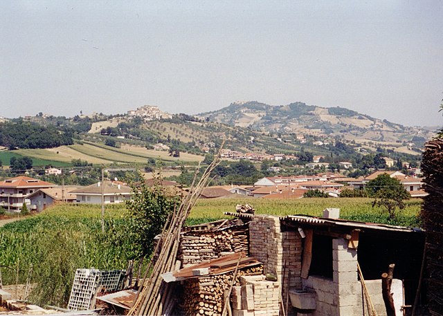
Castel Castagna (Castel Castagna)
.svg)
- Italian comune
 Hiking in Castel Castagna
Castel Castagna is a picturesque village located in the Teramo province of the Abruzzo region in Italy. Known for its stunning landscapes and rich natural heritage, it offers a variety of hiking opportunities for outdoor enthusiasts.
Key Highlights for Hiking in Castel Castagna:
-
Natural Scenery: The area around Castel Castagna is characterized by beautiful mountainous terrain, lush forests, and panoramic views of the surrounding landscape, including the Gran Sasso and Monti della Laga National Park.
-
Trails: There are several marked hiking trails that cater to various skill levels. These trails often range from easy walks through the countryside to more challenging paths that lead to higher altitudes.
-
Historical and Cultural Sites: While hiking, you may encounter ancient ruins, churches, and other historical landmarks that reflect the rich cultural heritage of the region.
-
Flora and Fauna: The region is home to diverse plant and animal life. Hikers might spot various species of birds, mammals, and unique plants along the trails.
-
Local Cuisine: After a hike, you can enjoy traditional Abruzzese dishes at local restaurants. The region is known for its hearty food, including handmade pasta, grilled meats, and local wines.
-
Accessibility: Castel Castagna is accessible by car, and many hikers choose to make it a base for exploring the surrounding national parks and natural reserves.
Tips for Hiking in Castel Castagna:
- Check Trail Conditions: Before heading out, check local resources for trail conditions and weather forecasts, as these can change rapidly in mountainous areas.
- Bring Proper Gear: Wear sturdy hiking boots, dress in layers, and bring enough water and snacks for your hike.
- Navigation Tools: Carry a map or use a GPS app to navigate the trails, as not all paths may be well-marked.
- Respect Nature: Follow Leave No Trace principles to preserve the natural beauty and integrity of the trails.
Whether you're an experienced hiker or a beginner, Castel Castagna offers a wonderful outdoor experience surrounded by breathtaking nature and rich history.
- Country:

- Postal Code: 64030
- Local Dialing Code: 0861
- Licence Plate Code: TE
- Coordinates: 42° 33' 0" N, 13° 43' 0" E


- GPS tracks (wikiloc): [Link]
- AboveSeaLevel: 452 м m
- Area: 18.16 sq km
- Population: 490
- Web site: http://www.cmgransasso.it/castelcastagna/
- Wikipedia en: wiki(en)
- Wikipedia: wiki(it)
- Wikidata storage: Wikidata: Q51429
- Wikipedia Commons Category: [Link]
- Freebase ID: [/m/0fs3x9]
- GeoNames ID: Alt: [6543626]
- VIAF ID: Alt: [238810510]
- OSM relation ID: [42071]
- ISTAT ID: 067010
- Italian cadastre code: C040
Shares border with regions:
Basciano
- Italian comune
Hiking in Basciano
Basciano is a small town located in the Abruzzo region of Italy. While it may not be as widely known for hiking as some larger areas, it is surrounded by beautiful landscapes typical of the Abruzzo region, which is known for its natural parks, mountains, and outdoor activities....
- Country:
- Postal Code: 64030
- Local Dialing Code: 0861
- Licence Plate Code: TE
- Coordinates: 42° 35' 47" N, 13° 44' 8" E
- GPS tracks (wikiloc): [Link]
- AboveSeaLevel: 388 м m
- Area: 18.85 sq km
- Population: 2373
- Web site: [Link]

Bisenti
- Italian comune
Hiking in Bisenti
Bisenti is a charming town located in the Abruzzo region of Italy, surrounded by beautiful landscapes that are perfect for hiking enthusiasts. The area offers a mix of natural beauty, historical sites, and local culture, making it an excellent destination for hikers of all levels. Here are some highlights of hiking in and around Bisenti:...
- Country:
- Postal Code: 64033
- Local Dialing Code: 0861
- Licence Plate Code: TE
- Coordinates: 42° 32' 0" N, 13° 48' 0" E
- GPS tracks (wikiloc): [Link]
- AboveSeaLevel: 274 м m
- Area: 30.88 sq km
- Population: 1885
- Web site: [Link]

Castelli, Abruzzo
- Italian comune
Hiking in Castelli, Abruzzo
Castelli, located in the province of Teramo in the Abruzzo region of Italy, is a picturesque village known for its stunning landscapes and rich history. It's surrounded by the Gran Sasso e Monti della Laga National Park, which offers a variety of hiking opportunities suited for different skill levels. Here are some highlights you might consider when planning a hiking trip in this beautiful area:...
- Country:
- Postal Code: 64041
- Local Dialing Code: 0861
- Licence Plate Code: TE
- Coordinates: 42° 29' 5" N, 13° 42' 43" E
- GPS tracks (wikiloc): [Link]
- AboveSeaLevel: 497 м m
- Area: 49.68 sq km
- Population: 1098
- Web site: [Link]

Cermignano
- Italian comune
Hiking in Cermignano
Cermignano, a charming town located in the Teramo province of Italy, offers a unique blend of natural beauty and cultural heritage. Here are some aspects to consider for hiking in and around Cermignano:...
- Country:
- Postal Code: 64037
- Local Dialing Code: 0861
- Licence Plate Code: TE
- Coordinates: 42° 35' 0" N, 13° 48' 0" E
- GPS tracks (wikiloc): [Link]
- AboveSeaLevel: 563 м m
- Area: 26.36 sq km
- Population: 1591
- Web site: [Link]

Colledara
- Italian comune
Hiking in Colledara
Colledara is a picturesque town located in the Abruzzo region of Italy, known for its stunning landscapes and outdoor activities, particularly hiking. The area is characterized by rolling hills, beautiful valleys, and proximity to the Gran Sasso and Monti della Laga National Park, which makes it an excellent destination for hikers of all levels....
- Country:
- Postal Code: 64042
- Local Dialing Code: 0861
- Licence Plate Code: TE
- Coordinates: 42° 32' 0" N, 13° 41' 0" E
- GPS tracks (wikiloc): [Link]
- AboveSeaLevel: 430 м m
- Area: 18.01 sq km
- Population: 2151
- Web site: [Link]

Isola del Gran Sasso d'Italia
- Italian comune
Hiking in Isola del Gran Sasso d'Italia
Isola del Gran Sasso d'Italia is a beautiful area in the Abruzzo region of Italy, known for its stunning mountainous landscapes, rich biodiversity, and a variety of hiking trails suitable for different skill levels. It’s part of the Gran Sasso e Monti della Laga National Park, the largest protected area in the Apennines....
- Country:
- Postal Code: 64045
- Local Dialing Code: 0861
- Licence Plate Code: TE
- Coordinates: 42° 30' 27" N, 13° 39' 28" E
- GPS tracks (wikiloc): [Link]
- AboveSeaLevel: 498 м m
- Area: 84.05 sq km
- Population: 4684
- Web site: [Link]
Penna Sant'Andrea
- Italian comune
Hiking in Penna Sant'Andrea
Penna Sant'Andrea, located in the Abruzzo region of Italy, is a hidden gem for hiking enthusiasts. Nestled in the picturesque Apennine Mountains, this area offers stunning landscapes, rich biodiversity, and a range of hiking trails suitable for different skill levels....
- Country:
- Postal Code: 64039
- Local Dialing Code: 0861
- Licence Plate Code: TE
- Coordinates: 42° 36' 0" N, 13° 46' 0" E
- GPS tracks (wikiloc): [Link]
- AboveSeaLevel: 413 м m
- Area: 11.1 sq km
- Population: 1763
- Web site: [Link]