Champdepraz (Champdepraz)
.svg)
- Italian comune
 Hiking in Champdepraz
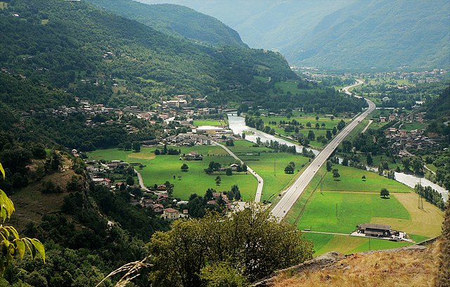
Champdepraz is a picturesque commune located in the Aosta Valley region of Italy, surrounded by the stunning Alpine landscape, which makes it a great spot for hiking enthusiasts. The area features a variety of trails suitable for different skill levels, offering breathtaking views of the mountains, lush valleys, and traditional chalets.
Key Highlights of Hiking in Champdepraz:
-
Diverse Trails: There are numerous hiking trails ranging from easy walks suitable for families to more challenging routes for experienced hikers. Some popular trails lead to scenic spots like the Chiot de Dzenas, and the views of the Mont Avic Natural Park.
-
Mont Avic Natural Park: This nearby park offers fantastic hiking opportunities, showcasing unique flora and fauna, glacial lakes, and stunning mountain vistas. Trails here can lead to the park’s cultural and historical sites as well.
-
Historical Sites: Hiking in Champdepraz can also lead you to several historical and cultural landmarks, such as ancient churches, castles, and traditional rural architecture that tell the story of the region.
-
Wildlife Observation: The region is home to diverse wildlife, including ibex, chamois, and various bird species. As you hike, keep an eye out for these animals, especially in quieter areas of the park.
-
Seasonal Variability: Hiking conditions can vary significantly depending on the season. Summer offers lush green landscapes and wildflowers, while autumn showcases vibrant fall colors. Winter hiking and snowshoeing are also popular, but ensure that you have appropriate gear and knowledge of the conditions.
-
Local Culture and Cuisine: After a day of hiking, you can enjoy local Aosta Valley cuisine in the nearby villages, featuring hearty dishes that reflect the mountainous terrain and traditional Alpine cooking.
-
Guided Tours: For those who prefer to explore with a knowledgeable guide, various local companies offer guided hiking tours that cater to all skill levels, helping campers understand the region's ecology and history.
Tips for Hiking in Champdepraz:
- Gear Up: Wear appropriate hiking boots and bring layers, as the weather can change rapidly in the mountains.
- Stay Hydrated: Carry enough water, especially on longer hikes.
- Respect Nature: Follow Leave No Trace principles, stay on marked trails, and respect the local wildlife.
- Check Trail Conditions: Before heading out, check trail conditions and weather forecasts, especially in the early or late hiking season.
Hiking in Champdepraz provides a perfect blend of adventure, beautiful landscapes, and a taste of local culture, ensuring a memorable experience for hikers of all levels.
- Country:

- Postal Code: 11020
- Local Dialing Code: 0125
- Licence Plate Code: AO
- Coordinates: 45° 41' 0" N, 7° 39' 0" E


- GPS tracks (wikiloc): [Link]
- AboveSeaLevel: 523 м m
- Area: 48.79 sq km
- Population: 714
- Web site: http://www.comune.champdepraz.ao.it
- Wikipedia en: wiki(en)
- Wikipedia: wiki(it)
- Wikidata storage: Wikidata: Q34927
- Wikipedia Commons Category: [Link]
- Wikipedia Commons Maps Category: [Link]
- Freebase ID: [/m/0fs_wk]
- GeoNames ID: Alt: [6537029]
- OSM relation ID: [45612]
- TGN ID: [1044198]
- ISTAT ID: 007017
- Italian cadastre code: C596
Shares border with regions:


Chambave
- Italian comune
Hiking in Chambave
Chambave, located in the Aosta Valley of Italy, offers scenic hiking opportunities amidst stunning Alpine landscapes. This charming village is surrounded by picturesque mountains, vineyards, and historical sites, making it a great base for outdoor enthusiasts....
- Country:
- Postal Code: 11023
- Local Dialing Code: 0166
- Licence Plate Code: AO
- Coordinates: 45° 45' 0" N, 7° 33' 0" E
- GPS tracks (wikiloc): [Link]
- AboveSeaLevel: 480 м m
- Area: 21.54 sq km
- Population: 937
- Web site: [Link]


Champorcher
- Italian comune
Hiking in Champorcher
Champorcher is a beautiful alpine village located in the Aosta Valley region of Italy, nestled in the Italian Alps. It offers a fantastic environment for hiking enthusiasts, featuring a diverse range of trails that cater to various skill levels, from casual walkers to experienced trekkers....
- Country:
- Postal Code: 11020
- Local Dialing Code: 0125
- Licence Plate Code: AO
- Coordinates: 45° 37' 0" N, 7° 37' 0" E
- GPS tracks (wikiloc): [Link]
- AboveSeaLevel: 1427 м m
- Area: 68.43 sq km
- Population: 391
- Web site: [Link]


Châtillon
- Italian comune
Hiking in Châtillon
Châtillon is a charming town located in the Aosta Valley region of Italy, surrounded by stunning mountainous landscapes that make it a great starting point for hiking enthusiasts. Here’s what you should know about hiking in and around Châtillon:...
- Country:
- Postal Code: 11024
- Local Dialing Code: 0166
- Licence Plate Code: AO
- Coordinates: 45° 45' 0" N, 7° 37' 0" E
- GPS tracks (wikiloc): [Link]
- AboveSeaLevel: 549 м m
- Area: 39.68 sq km
- Population: 4654
- Web site: [Link]


Fénis
- Italian comune
Hiking in Fénis
Fénis is a picturesque village located in the Aosta Valley region of Italy, known for its stunning landscapes, rich history, and outdoor activities, making it an excellent destination for hiking enthusiasts. Here are some key points to consider when exploring hiking in Fénis:...
- Country:
- Postal Code: 11020
- Local Dialing Code: 0165
- Licence Plate Code: AO
- Coordinates: 45° 44' 5" N, 7° 29' 44" E
- GPS tracks (wikiloc): [Link]
- AboveSeaLevel: 541 м m
- Area: 68.12 sq km
- Population: 1818
- Web site: [Link]


Issogne
- Italian comune
Hiking in Issogne
Issogne is a charming village located in the Aosta Valley region of Italy, known for its stunning landscapes and rich history. Hiking in and around Issogne offers diverse trails that cater to different skill levels, with options for both beginners and experienced hikers....
- Country:
- Postal Code: 11020
- Local Dialing Code: 0125
- Licence Plate Code: AO
- Coordinates: 45° 39' 0" N, 7° 41' 0" E
- GPS tracks (wikiloc): [Link]
- AboveSeaLevel: 387 м m
- Area: 23.61 sq km
- Population: 1386
- Web site: [Link]
Montjovet
- Italian comune
Hiking in Montjovet
Montjovet is a picturesque commune located in the Aosta Valley region of Italy, nestled in the foothills of the Alps. This area is known for its stunning landscapes, diverse ecosystems, and a variety of hiking opportunities that cater to different skill levels. Here are some key points to consider when hiking in Montjovet:...
- Country:
- Postal Code: 11020
- Local Dialing Code: 0166
- Licence Plate Code: AO
- Coordinates: 45° 42' 0" N, 7° 41' 0" E
- GPS tracks (wikiloc): [Link]
- AboveSeaLevel: 406 м m
- Area: 18.76 sq km
- Population: 1774
- Web site: [Link]


Pontey
- Italian comune
Hiking in Pontey
Pontey is a small village located in the Aosta Valley region of Italy, surrounded by picturesque landscapes and beautiful mountain scenery. It offers several hiking opportunities that are suitable for a range of skill levels, from beginner to more experienced hikers. Here are some key points about hiking in Pontey:...
- Country:
- Postal Code: 11024
- Local Dialing Code: 0166
- Licence Plate Code: AO
- Coordinates: 45° 44' 0" N, 7° 35' 0" E
- GPS tracks (wikiloc): [Link]
- AboveSeaLevel: 523 м m
- Area: 15.75 sq km
- Population: 815
- Web site: [Link]

Verrès
- Italian comune
Hiking in Verrès
Verrès is a charming town located in the Aosta Valley region of Italy, surrounded by beautiful alpine scenery, making it an excellent destination for hiking enthusiasts. The surrounding area offers a variety of trails suitable for different skill levels, from leisurely walks to more challenging alpine hikes....
- Country:
- Postal Code: 11029
- Local Dialing Code: 0125
- Licence Plate Code: AO
- Coordinates: 45° 40' 0" N, 7° 41' 21" E
- GPS tracks (wikiloc): [Link]
- AboveSeaLevel: 391 м m
- Area: 8.36 sq km
- Population: 2642
- Web site: [Link]