Fénis (Fénis)
- Italian comune
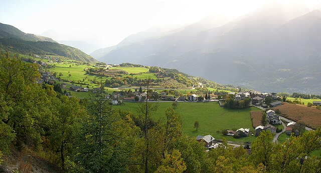
Fénis is a picturesque village located in the Aosta Valley region of Italy, known for its stunning landscapes, rich history, and outdoor activities, making it an excellent destination for hiking enthusiasts. Here are some key points to consider when exploring hiking in Fénis:
Trails and Routes
-
Valle d’Aosta Trails: The region has a well-maintained network of hiking trails that cater to various skill levels, from easy walks to challenging treks. Most trails offer breathtaking views of the surrounding mountains and valleys.
-
Fénis Castle Hike: One popular route starts from the village and leads to the impressive Fénis Castle, an iconic medieval structure. The hike up involves gentle slopes and offers the opportunity to explore the castle itself.
-
Mont Avic Natural Park: This park, located nearby, features a variety of trails through pristine natural environments with diverse flora and fauna. There are several itineraries for different hiking levels, including routes that lead to beautiful lakes.
-
Alpe di Fénis: This area offers routes that take you through alpine landscapes, including meadows and forests, providing a peaceful hiking experience. Depending on the season, you might encounter wildflowers or snow-covered trails.
Best Time to Hike
- Summer (June to September): This is the most popular time for hiking, with pleasant weather and longer daylight hours, making it ideal for exploring the trails.
- Early Autumn (September to October): The fall foliage adds a beautiful dimension to the hikes, and temperatures remain mild for trekking.
Tips for Hiking in Fénis
- Map and Navigation: Carry a detailed hiking map of the area or use a reliable hiking app to ensure you stay on the correct paths.
- Gear: Wear appropriate hiking boots with good grip and bring layers since mountain weather can change rapidly. Essentials include water, snacks, and a first-aid kit.
- Cultural Respect: Be mindful of the local environment and cultural heritage. The Aosta Valley is home to diverse wildlife, so it's important to follow Leave No Trace principles.
Nearby Attractions
- Aosta: The capital of the region, known for its Roman ruins and charming old town.
- Gressoney and Champorcher: Nearby valleys that offer even more hiking opportunities and scenic beauty.
Hiking in Fénis combines natural beauty with cultural heritage, so it’s a fantastic way to immerse yourself in the stunning landscapes of the Aosta Valley. Enjoy your adventure!
- Country:

- Postal Code: 11020
- Local Dialing Code: 0165
- Licence Plate Code: AO
- Coordinates: 45° 44' 5" N, 7° 29' 44" E


- GPS tracks (wikiloc): [Link]
- AboveSeaLevel: 541 м m
- Area: 68.12 sq km
- Population: 1818
- Web site: http://www.comune.fenis.ao.it
- Wikipedia en: wiki(en)
- Wikipedia: wiki(it)
- Wikidata storage: Wikidata: Q35039
- Wikipedia Commons Gallery: [Link]
- Wikipedia Commons Category: [Link]
- Wikipedia Commons Maps Category: [Link]
- Freebase ID: [/m/0fwy_9]
- GeoNames ID: Alt: [6542491]
- VIAF ID: Alt: [240525593]
- OSM relation ID: [45569]
- ISTAT ID: 007027
- Italian cadastre code: D537
Shares border with regions:

Chambave
- Italian comune
Chambave, located in the Aosta Valley of Italy, offers scenic hiking opportunities amidst stunning Alpine landscapes. This charming village is surrounded by picturesque mountains, vineyards, and historical sites, making it a great base for outdoor enthusiasts....
- Country:

- Postal Code: 11023
- Local Dialing Code: 0166
- Licence Plate Code: AO
- Coordinates: 45° 45' 0" N, 7° 33' 0" E


- GPS tracks (wikiloc): [Link]
- AboveSeaLevel: 480 м m
- Area: 21.54 sq km
- Population: 937
- Web site: [Link]


Champdepraz
- Italian comune
Champdepraz is a picturesque commune located in the Aosta Valley region of Italy, surrounded by the stunning Alpine landscape, which makes it a great spot for hiking enthusiasts. The area features a variety of trails suitable for different skill levels, offering breathtaking views of the mountains, lush valleys, and traditional chalets....
- Country:

- Postal Code: 11020
- Local Dialing Code: 0125
- Licence Plate Code: AO
- Coordinates: 45° 41' 0" N, 7° 39' 0" E


- GPS tracks (wikiloc): [Link]
- AboveSeaLevel: 523 м m
- Area: 48.79 sq km
- Population: 714
- Web site: [Link]


Champorcher
- Italian comune
Champorcher is a beautiful alpine village located in the Aosta Valley region of Italy, nestled in the Italian Alps. It offers a fantastic environment for hiking enthusiasts, featuring a diverse range of trails that cater to various skill levels, from casual walkers to experienced trekkers....
- Country:

- Postal Code: 11020
- Local Dialing Code: 0125
- Licence Plate Code: AO
- Coordinates: 45° 37' 0" N, 7° 37' 0" E


- GPS tracks (wikiloc): [Link]
- AboveSeaLevel: 1427 м m
- Area: 68.43 sq km
- Population: 391
- Web site: [Link]


Cogne
- town and comune in Italy
Cogne is a stunning valley located in the Aosta region of northern Italy, surrounded by the majestic Grand Paradiso National Park. It offers a variety of hiking opportunities that cater to different skill levels and preferences, from leisurely walks to challenging treks....
- Country:

- Postal Code: 11012
- Local Dialing Code: 0165
- Licence Plate Code: AO
- Coordinates: 45° 36' 27" N, 7° 21' 29" E


- GPS tracks (wikiloc): [Link]
- AboveSeaLevel: 1534 м m
- Area: 213.04 sq km
- Population: 1370
- Web site: [Link]


Nus
- Italian comune
Nus, a charming village located in the Aosta Valley region of Italy, offers some wonderful hiking opportunities. The picturesque landscape is characterized by mountains, valleys, and lush greenery, making it a great destination for outdoor enthusiasts. Here are some key points about hiking in Nus:...
- Country:

- Postal Code: 11020
- Local Dialing Code: 0165
- Licence Plate Code: AO
- Coordinates: 45° 44' 0" N, 7° 28' 0" E


- GPS tracks (wikiloc): [Link]
- AboveSeaLevel: 529 м m
- Area: 57.36 sq km
- Population: 2991
- Web site: [Link]


Saint-Marcel, Aosta Valley
- Italian comune
 Hiking in Saint-Marcel, Aosta Valley
Saint-Marcel, located in the Aosta Valley region of Italy, is a beautiful area for hiking enthusiasts, offering stunning landscapes typical of the Alps. The valley is known for its breathtaking views, natural beauty, and a variety of hiking trails that cater to different skill levels....
- Country:

- Postal Code: 11020
- Local Dialing Code: 0165
- Licence Plate Code: AO
- Coordinates: 45° 43' 53" N, 7° 26' 54" E


- GPS tracks (wikiloc): [Link]
- AboveSeaLevel: 625 м m
- Area: 42.38 sq km
- Population: 1348
- Web site: [Link]


Verrayes
- Italian comune
Verrayes is a beautiful municipality located in the Aosta Valley region of Italy. It's known for its stunning landscapes, charming villages, and the surrounding mountains, which offer a variety of hiking opportunities suitable for different skill levels. Here are some key points about hiking in Verrayes:...
- Country:

- Postal Code: 11020
- Local Dialing Code: 0166
- Licence Plate Code: AO
- Coordinates: 45° 46' 0" N, 7° 32' 0" E


- GPS tracks (wikiloc): [Link]
- AboveSeaLevel: 1017 м m
- Area: 22.36 sq km
- Population: 1303
- Web site: [Link]
