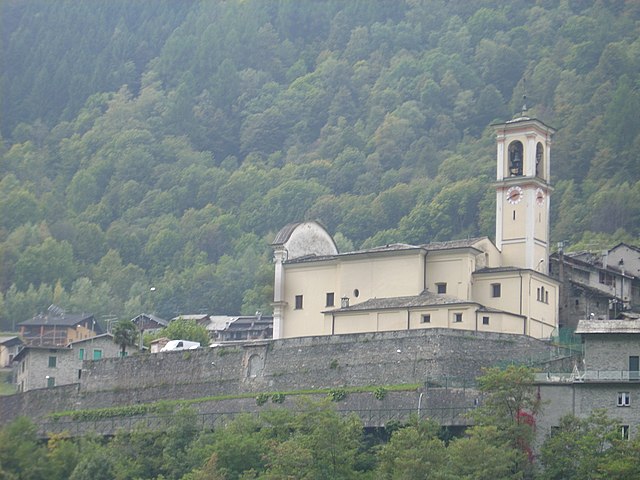
Chiesa in Valmalenco (Chiesa in Valmalenco)
.svg)
- Italian comune
 Hiking in Chiesa in Valmalenco
Chiesa in Valmalenco is a beautiful destination for hiking, located in the Italian Alps within the Lombardy region. It is characterized by stunning landscapes, rich biodiversity, and a variety of trails suitable for hikers of all levels. Here’s an overview of what you can expect when hiking in Chiesa in Valmalenco:
Terrain and Scenery
- Alpine Environment: The area features classic alpine landscapes, including rugged mountains, lush valleys, and picturesque lakes. The views are often breathtaking, especially where you can see the peaks of the Bernina Range.
- Flora and Fauna: The region is home to diverse plant and animal species. You may encounter alpine flowers, such as edelweiss, as well as wildlife like chamois and marmots.
Hiking Trails
Chiesa in Valmalenco offers a wide range of hiking trails, from easy, family-friendly walks to challenging alpine routes. A few notable paths include:
- Valmalenco Trail: This long-distance path takes you through the entire valley, showcasing its natural beauty and cultural heritage. It's ideal for those looking for a multi-day trekking experience.
- Giro dei Fiori: A shorter, scenic trail perfect for families. It meanders through flower-filled meadows and offers easy access to various viewpoints.
- Sentiero delle Marmotte: A moderate trail that is popular for wildlife spotting, particularly its namesake, the marmots.
Practical Information
- Best Time to Hike: The hiking season typically runs from late spring (May) until early autumn (October). Summer is ideal for clear views and milder temperatures.
- Gear: Always ensure you're equipped with appropriate gear, including sturdy footwear, weather-appropriate clothing, and trekking poles if needed.
- Safety: It’s advisable to check local weather forecasts, carry a map or GPS, and let someone know your hiking plans. Some trails can be steep or rocky, so always assess your abilities.
Guidance and Support
If you're new to hiking or unfamiliar with the terrain, consider joining organized hikes or tours led by local guides. They can provide valuable insights into the area's natural history and ensure a safe and enjoyable experience.
Additional Activities
In addition to hiking, Chiesa in Valmalenco offers options such as rock climbing, mountain biking, and during the winter months, skiing and snowboarding.
Overall, hiking in Chiesa in Valmalenco is a rewarding experience that allows you to connect with nature while enjoying the stunning alpine scenery. Whether you're a beginner or an experienced hiker, there’s something for everyone in this beautiful part of the Italian Alps.
- Country:

- Postal Code: 23023
- Local Dialing Code: 0342
- Licence Plate Code: SO
- Coordinates: 46° 16' 0" N, 9° 51' 0" E


- GPS tracks (wikiloc): [Link]
- AboveSeaLevel: 800 м m
- Area: 107.6 sq km
- Population: 2482
- Web site: http://www.comune.chiesainvalmalenco.so.it
- Wikipedia en: wiki(en)
- Wikipedia: wiki(it)
- Wikidata storage: Wikidata: Q40280
- Wikipedia Commons Gallery: [Link]
- Wikipedia Commons Category: [Link]
- Freebase ID: [/m/0gj2vc]
- GeoNames ID: Alt: [6539471]
- VIAF ID: Alt: [150515538]
- OSM relation ID: [47078]
- GND ID: Alt: [7652399-8]
- Library of Congress authority ID: Alt: [no2010130691]
- UN/LOCODE: [ITCVM]
- ISTAT ID: 014019
- Italian cadastre code: C628
Shares border with regions:

Torre di Santa Maria
- Italian comune
Hiking in Torre di Santa Maria
Torre di Santa Maria, located in the beautiful region of Lombardy in northern Italy, is an excellent destination for hiking enthusiasts. Nestled in the Valtellina valley, it is surrounded by stunning landscapes, including mountains, valleys, and lush forests....
- Country:
- Postal Code: 23020
- Local Dialing Code: 0342
- Licence Plate Code: SO
- Coordinates: 46° 14' 0" N, 9° 51' 0" E
- GPS tracks (wikiloc): [Link]
- AboveSeaLevel: 795 м m
- Area: 44.24 sq km
- Population: 752
- Web site: [Link]
Lanzada
- Italian comune
Hiking in Lanzada
Lanzada, located on the beautiful Galician coast in Spain, is known for its stunning beaches, picturesque landscapes, and vibrant natural surroundings, making it a great destination for hiking enthusiasts. Here’s an overview of what to expect when hiking in the Lanzada area:...
- Country:
- Postal Code: 23020
- Local Dialing Code: 0342
- Licence Plate Code: SO
- Coordinates: 46° 16' 0" N, 9° 52' 0" E
- GPS tracks (wikiloc): [Link]
- AboveSeaLevel: 1000 м m
- Area: 117.17 sq km
- Population: 1335
- Web site: [Link]
Buglio in Monte
- Italian comune
Hiking in Buglio in Monte
Buglio in Monte is a picturesque village located in the Lombardy region of Italy, in the province of Sondrio. The area is known for its stunning natural landscapes, making it an excellent destination for hiking enthusiasts....
- Country:
- Postal Code: 23010
- Local Dialing Code: 0342
- Licence Plate Code: SO
- Coordinates: 46° 11' 0" N, 9° 41' 0" E
- GPS tracks (wikiloc): [Link]
- AboveSeaLevel: 577 м m
- Area: 27.71 sq km
- Population: 2012
- Web site: [Link]

Caspoggio
- Italian comune
Hiking in Caspoggio
Caspoggio is a charming village located in the Valtellina valley in the Lombardy region of northern Italy, known for its stunning natural landscapes and outdoor recreational opportunities. Hiking in and around Caspoggio provides breathtaking views, diverse trails, and the chance to explore the rich flora and fauna of the area....
- Country:
- Postal Code: 23020
- Local Dialing Code: 0342
- Licence Plate Code: SO
- Coordinates: 46° 16' 0" N, 9° 52' 0" E
- GPS tracks (wikiloc): [Link]
- AboveSeaLevel: 1098 м m
- Area: 7.31 sq km
- Population: 1377
- Web site: [Link]
Val Masino
- Italian comune
Hiking in Val Masino
Val Masino, located in the Valtellina region of northern Italy, is a stunning destination for hiking enthusiasts. Known for its dramatic landscapes, granite cliffs, lush forests, and clear rivers, Val Masino offers a variety of hiking trails suitable for different skill levels, from leisurely walks to challenging treks....
- Country:
- Postal Code: 23010
- Local Dialing Code: 0342
- Licence Plate Code: SO
- Coordinates: 46° 13' 0" N, 9° 38' 0" E
- GPS tracks (wikiloc): [Link]
- AboveSeaLevel: 787 м m
- Area: 116.71 sq km
- Population: 891
- Web site: [Link]


Sils im Engadin/Segl
- municipality in Switzerland
Hiking in Sils im Engadin/Segl
Sils im Engadin-Segli is a picturesque village located in the Engadine Valley of Switzerland, renowned for its stunning landscapes and excellent hiking opportunities. This area is part of the larger UNESCO World Heritage site of the Swiss Alps and offers a range of trails suitable for different skill levels....
- Country:

- Postal Code: 7514
- Local Dialing Code: 081
- Licence Plate Code: GR
- Coordinates: 46° 25' 59" N, 9° 45' 59" E
- GPS tracks (wikiloc): [Link]
- AboveSeaLevel: 1803 м m
- Area: 63.57 sq km
- Population: 691
- Web site: [Link]


Bregaglia
- municipality in Switzerland
Hiking in Bregaglia
Bregaglia, a stunning valley in the southern part of Switzerland, is known for its picturesque landscapes, charming villages, and a wide range of hiking opportunities. Here are some highlights about hiking in the region:...
- Country:
- Postal Code: 7603, 7605, 7606, 7608, 7610, 7516
- Local Dialing Code: 081
- Licence Plate Code: GR
- Coordinates: 46° 20' 0" N, 9° 35' 0" E
- GPS tracks (wikiloc): [Link]
- AboveSeaLevel: 994 м m
- Area: 251.45 sq km
- Population: 1531
- Web site: [Link]