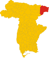
Chiusaforte (Chiusaforte)
.svg)
- Italian comune
 Hiking in Chiusaforte
Chiusaforte, located in the Friuli Venezia Giulia region of Italy, is a great destination for hiking enthusiasts. Nestled in the Julian Alps, this area offers a stunning landscape characterized by towering mountains, lush valleys, and clear rivers.
Hiking Trails:
-
Val Melenco: This valley offers various scenic hikes, from beginner-friendly trails to more challenging ascents. The views of the surrounding peaks are breathtaking, making it a great choice for all levels of hikers.
-
Sella Nevea: This mountain pass allows access to several trails, including those leading to the Crista di Torre Glava or the Monte Canin. These hikes vary in difficulty and reward hikers with panoramic views of the Julian Alps and the surrounding landscapes.
-
Cascate del Rio Bianco: A relatively easy trail leading to beautiful waterfalls. It’s a family-friendly option, suitable for those who are looking for a short day hike with stunning natural scenery.
Practical Information:
- Best Time to Visit: The hiking season typically runs from late spring to early fall, with summer being particularly popular due to the milder weather.
- Difficulty Levels: Trails range from easy to challenging, so it’s important to choose a trail that matches your experience level.
- Gear: Proper hiking boots, weather-appropriate clothing, and plenty of water are essential. Additionally, a map or GPS device can help prevent getting lost, as some trails may not be well-marked.
Additional Activities:
Beyond hiking, Chiusaforte is also great for rock climbing, cycling, and exploring local flora and fauna. The region's rich history can be experienced through its small towns and cultural sites as well.
Safety Tips:
- Always check the weather before heading out.
- Inform someone of your hiking plans.
- Start early to ensure you have plenty of daylight.
- Be aware of your physical limits and the trail difficulty.
Whether you're looking for a tranquil walk or a challenging mountain ascent, Chiusaforte offers a diverse range of options for outdoor enthusiasts. Enjoy your hiking adventure!
- Country:

- Postal Code: 33010
- Local Dialing Code: 0433
- Licence Plate Code: UD
- Coordinates: 46° 24' 0" N, 13° 19' 0" E


- GPS tracks (wikiloc): [Link]
- AboveSeaLevel: 391 м m
- Area: 100.2 sq km
- Population: 628
- Web site: http://www.comune.chiusaforte.ud.it
- Wikipedia en: wiki(en)
- Wikipedia: wiki(it)
- Wikidata storage: Wikidata: Q53243
- Wikipedia Commons Category: [Link]
- Freebase ID: [/m/0gk8nc]
- GeoNames ID: Alt: [6536307]
- VIAF ID: Alt: [242332400]
- OSM relation ID: [79078]
- Digital Atlas of the Roman Empire ID: [21289]
- ISTAT ID: 030025
- Italian cadastre code: C656
Shares border with regions:

Tarvisio
- town in Italy
Hiking in Tarvisio
Tarvisio, located in the northeastern part of Italy near the borders with Austria and Slovenia, is a beautiful destination for hiking enthusiasts. It is situated in the Julian Alps and offers a wide range of trails that cater to various skill levels, from easy strolls to challenging treks. Here are some highlights of hiking in Tarvisio:...
- Country:
- Postal Code: 33018
- Local Dialing Code: 0428
- Licence Plate Code: UD
- Coordinates: 46° 30' 0" N, 13° 34' 0" E
- GPS tracks (wikiloc): [Link]
- AboveSeaLevel: 754 м m
- Area: 208.36 sq km
- Population: 4224
- Web site: [Link]


Dogna
- Italian comune
Hiking in Dogna
Dogna is a small town located in the Friuli Venezia Giulia region of northeastern Italy, nestled in the Julian Alps. It's known for its beautiful landscapes and outdoor recreational opportunities, including hiking. Here are some key points to consider if you're planning a hiking trip in the Dogna area:...
- Country:
- Postal Code: 33010
- Local Dialing Code: 0428
- Licence Plate Code: UD
- Coordinates: 46° 26' 53" N, 13° 18' 54" E
- GPS tracks (wikiloc): [Link]
- AboveSeaLevel: 430 м m
- Area: 70.37 sq km
- Population: 168
- Web site: [Link]


Malborghetto Valbruna
- Italian comune
Hiking in Malborghetto Valbruna
Malborghetto Valbruna is a picturesque village located in the Valcanale region of northeastern Italy, close to the Austrian border. It is surrounded by stunning Alpine scenery and offers a variety of hiking opportunities for all skill levels. Here are some highlights and tips for hiking in this area:...
- Country:
- Postal Code: 33010
- Local Dialing Code: 0428
- Licence Plate Code: UD
- Coordinates: 46° 30' 24" N, 13° 26' 22" E
- GPS tracks (wikiloc): [Link]
- AboveSeaLevel: 721 м m
- Area: 124.21 sq km
- Population: 919
- Web site: [Link]


Moggio Udinese
- Italian comune
Hiking in Moggio Udinese
Moggio Udinese, located in the Friuli-Venezia Giulia region of northeastern Italy, is a charming destination for hiking enthusiasts. Nestled in the Julian Alps, the area is characterized by lush landscapes, picturesque valleys, and majestic mountain views. Here are some highlights and tips for hiking in and around Moggio Udinese:...
- Country:
- Postal Code: 33015
- Local Dialing Code: 0433
- Licence Plate Code: UD
- Coordinates: 46° 25' 0" N, 13° 12' 0" E
- GPS tracks (wikiloc): [Link]
- AboveSeaLevel: 341 м m
- Area: 142.44 sq km
- Population: 1703
- Web site: [Link]


Resia, Friuli
- Italian comune
Hiking in Resia, Friuli
Resia, located in the Friuli Venezia Giulia region of northern Italy, is a breathtaking destination for hiking enthusiasts. Nestled in the heart of the Julian Alps, it offers a variety of trails that cater to different skill levels, from leisurely walks to more challenging hikes....
- Country:
- Postal Code: 33010
- Local Dialing Code: 0433
- Licence Plate Code: UD
- Coordinates: 46° 22' 5" N, 13° 18' 7" E
- GPS tracks (wikiloc): [Link]
- AboveSeaLevel: 492 м m
- Area: 119.31 sq km
- Population: 1000
- Web site: [Link]

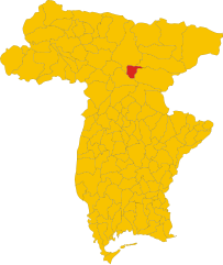
Resiutta
- Italian comune
Hiking in Resiutta
Resiutta, a charming village located in the Friuli Venezia Giulia region of northern Italy, serves as a great base for hiking enthusiasts. The area is nestled in the Julian Alps and is surrounded by stunning natural landscapes, including forests, mountains, and rivers, offering a variety of hiking trails for different skill levels....
- Country:
- Postal Code: 33010
- Local Dialing Code: 0433
- Licence Plate Code: UD
- Coordinates: 46° 24' 0" N, 13° 13' 0" E
- GPS tracks (wikiloc): [Link]
- AboveSeaLevel: 316 м m
- Area: 20.36 sq km
- Population: 286
- Web site: [Link]