Crevans-et-la-Chapelle-lès-Granges (Crevans-et-la-Chapelle-lès-Granges)

- commune in Haute-Saône, France
 Hiking in Crevans-et-la-Chapelle-lès-Granges
Crevans-et-la-Chapelle-lès-Granges, a small commune in the Bourgogne-Franche-Comté region of France, offers a scenic backdrop for hiking enthusiasts. This area is characterized by its charming rural landscape, rolling hills, and relatively untouched natural beauty. Here are some key aspects to consider if you're planning to hike in or around Crevans-et-la-Chapelle-lès-Granges:
Trails and Routes
- Local Trails: The region features various walking paths that meander through forests, fields, and along rivers. While it may not have the extensive well-known hiking trails of larger national parks, the local paths can provide a peaceful and immersive experience in nature.
- Connecting Routes: You can explore nearby areas by connecting to longer trails in the Bourgogne-Franche-Comté region. These routes may lead to picturesque villages, vineyards, and historical sites.
Scenic Highlights
- Natural Landscapes: Hikers can enjoy panoramic views of the surrounding countryside, with opportunities to observe local flora and fauna. The mix of open fields and wooded areas makes for diverse ecosystems.
- Cultural Sites: If you're interested in history, nearby towns may include features like old chapels, traditional farmhouses, and other historical landmarks.
Hiking Tips
- Trail Maps: It's a good idea to carry a detailed trail map or have a GPS device. Local tourist information centers may provide valuable resources, including maps and guidance on the best routes.
- Weather Preparation: The weather can change quickly in rural settings, so be sure to check the forecast and dress in layers. Bring rain gear if there's a chance of precipitation.
- Safety: Always inform someone of your hiking plans, especially if you're exploring less-frequented paths. Carry enough water, snacks, and a first-aid kit.
Accessibility
- Transport: Depending on where you're coming from, accessing the trails could involve a short drive from nearby towns. Public transport services may also lead to the area, but check the schedules in advance.
If you enjoy gentle hikes amidst tranquil nature and small-town charm, Crevans-et-la-Chapelle-lès-Granges can be a delightful destination. Just remember to plan accordingly for a safe and enjoyable adventure!
- Country:

- Postal Code: 70400
- Coordinates: 47° 33' 7" N, 6° 35' 7" E


- GPS tracks (wikiloc): [Link]
- AboveSeaLevel: 303 м m
- Area: 3.91 sq km
- Population: 255
- Wikipedia en: wiki(en)
- Wikipedia: wiki(fr)
- Wikidata storage: Wikidata: Q733623
- Wikipedia Commons Category: [Link]
- Freebase ID: [/m/03ntmjj]
- GeoNames ID: Alt: [6441901]
- SIREN number: [217001874]
- BnF ID: [15272581b]
- INSEE municipality code: 70187
Shares border with regions:

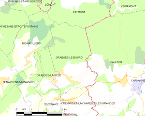
Granges-le-Bourg
- commune in Haute-Saône, France
- Country:
- Postal Code: 70400
- Coordinates: 47° 33' 54" N, 6° 35' 9" E
- GPS tracks (wikiloc): [Link]
- Area: 10.35 sq km
- Population: 383


Gémonval
- commune in Doubs, France
Hiking in Gémonval
Gémonval, while not widely known as a hiking destination, offers beautiful landscapes and trails for those looking to explore the outdoors. If you’re planning a hiking trip there, here are a few tips and information that may enhance your experience:...
- Country:
- Postal Code: 25250
- Coordinates: 47° 31' 56" N, 6° 35' 19" E
- GPS tracks (wikiloc): [Link]
- Area: 3.39 sq km
- Population: 84


Secenans
- commune in Haute-Saône, France
Hiking in Secenans
I’m sorry, but it appears there may be a typo in your query regarding "Secenans." If you meant "Sicily," "Sedona," or another specific hiking destination, please clarify, and I’d be happy to provide information on hiking in that area! If it is a specific local area or trail, please provide more details so I can assist you better....
- Country:
- Postal Code: 70400
- Coordinates: 47° 33' 12" N, 6° 34' 28" E
- GPS tracks (wikiloc): [Link]
- Area: 2.88 sq km
- Population: 176


Saulnot
- commune in Haute-Saône, France
Hiking in Saulnot
Saulnot is a quaint village located in the Bourgogne-Franche-Comté region of France, surrounded by beautiful natural landscapes that make it an appealing destination for hiking enthusiasts. The area offers a mix of scenic trails that cater to various skill levels, from leisurely walks to more challenging hikes....
- Country:
- Postal Code: 70400
- Coordinates: 47° 33' 45" N, 6° 38' 0" E
- GPS tracks (wikiloc): [Link]
- Area: 26.73 sq km
- Population: 748
- Web site: [Link]