canton of Villersexel (canton de Villersexel)

- canton of France
 Hiking in canton of Villersexel
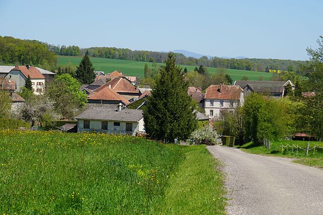
The Canton of Villersexel, located in the Haute-Saône department of the Bourgogne-Franche-Comté region in eastern France, offers a variety of hiking opportunities that showcase its beautiful landscapes, historical sites, and rich natural heritage.
Key Highlights for Hiking in the Canton of Villersexel:
-
Natural Landscapes: The area is characterized by rolling hills, forests, and agricultural fields. Hikers can enjoy diverse terrains, including wooded paths and open fields, which are particularly beautiful in the spring and fall.
-
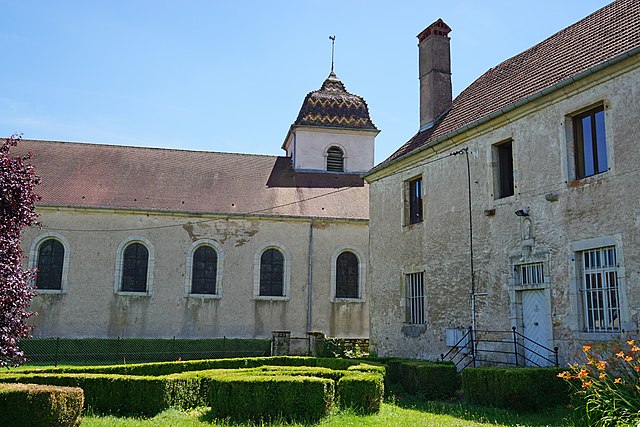
Historical Sites: While hiking, you might encounter various historical landmarks, including small villages with traditional architecture, ancient churches, and remnants of historical importance tied to the region's past.
-
Trails: There are several marked trails for different skill levels. The routes can vary in difficulty, so it’s important to choose a trail that matches your experience level. Make sure to check local maps or guides for well-maintained trails and recommended routes.
-
Wildlife: The area is home to various wildlife, making it a great destination for nature lovers. Keep an eye out for birds, deer, and other woodland creatures as you trek through the natural environments.
-
Climate: The region experiences a continental climate, so be prepared for varying weather conditions. It’s advisable to check the weather before your hike and to dress in layers.
-
Local Culture: The Canton of Villersexel has a rich cultural heritage. Engaging with locals or visiting small cafés and shops can enhance your hiking experience with a taste of the regional cuisine and hospitality.
-
Safety Tips: As with any hike, it’s important to stay on marked trails, carry sufficient water and snacks, wear appropriate hiking gear, and inform someone about your hiking plans. It’s also beneficial to have a map or a GPS device for navigation.
If you’re planning a hiking trip in Villersexel, make sure to take the time to enjoy the peaceful surroundings and the scenic views that the area offers, along with the chance to learn more about the local culture and history. Happy hiking!
- Country:

- Capital: Villersexel
- Coordinates: 47° 33' 5" N, 6° 26' 2" E


- GPS tracks (wikiloc): [Link]
- Population: 11882
- Wikipedia en: wiki(en)
- Wikipedia: wiki(fr)
- Wikidata storage: Wikidata: Q1700463
- INSEE canton code: [7017]
Includes regions:


Senargent-Mignafans
- commune in Haute-Saône, France
- Country:
- Postal Code: 70110
- Coordinates: 47° 33' 54" N, 6° 31' 34" E
- GPS tracks (wikiloc): [Link]
- AboveSeaLevel: 302 м m
- Area: 10.77 sq km
- Population: 300
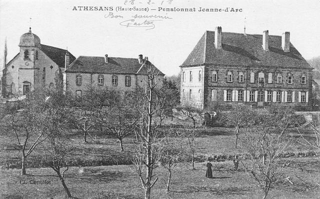

Athesans-Étroitefontaine
- commune in Haute-Saône, France
- Country:
- Postal Code: 70110
- Coordinates: 47° 35' 48" N, 6° 30' 37" E
- GPS tracks (wikiloc): [Link]
- AboveSeaLevel: 390 м m
- Area: 12.88 sq km
- Population: 662

Villafans
- commune in Haute-Saône, France
- Country:
- Postal Code: 70110
- Coordinates: 47° 34' 52" N, 6° 28' 20" E
- GPS tracks (wikiloc): [Link]
- Area: 6.44 sq km
- Population: 208

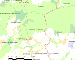
Granges-le-Bourg
- commune in Haute-Saône, France
- Country:
- Postal Code: 70400
- Coordinates: 47° 33' 54" N, 6° 35' 9" E
- GPS tracks (wikiloc): [Link]
- Area: 10.35 sq km
- Population: 383


Aillevans
- commune in Haute-Saône, France
- Country:
- Postal Code: 70110
- Coordinates: 47° 35' 29" N, 6° 24' 55" E
- GPS tracks (wikiloc): [Link]
- Area: 5.78 sq km
- Population: 150


Georfans
- commune in Haute-Saône, France
Hiking in Georfans
It seems like you might be referring to the "Georgian" region or perhaps a specific hiking area, but "Georfans" does not appear to be a recognized hiking location. Could you clarify if you meant “Georgia” (the country) or a specific national park or region?...
- Country:
- Postal Code: 70110
- Coordinates: 47° 32' 11" N, 6° 30' 45" E
- GPS tracks (wikiloc): [Link]
- Area: 2.99 sq km
- Population: 60


Les Magny
- commune in Haute-Saône, France
- Country:
- Postal Code: 70110
- Coordinates: 47° 31' 35" N, 6° 27' 14" E
- GPS tracks (wikiloc): [Link]
- Area: 11.46 sq km
- Population: 140

Moimay
- commune in Haute-Saône, France
- Country:
- Postal Code: 70110
- Coordinates: 47° 33' 10" N, 6° 24' 31" E
- GPS tracks (wikiloc): [Link]
- Area: 6.22 sq km
- Population: 234
- Web site: [Link]


Crevans-et-la-Chapelle-lès-Granges
- commune in Haute-Saône, France
Hiking in Crevans-et-la-Chapelle-lès-Granges
Crevans-et-la-Chapelle-lès-Granges, a small commune in the Bourgogne-Franche-Comté region of France, offers a scenic backdrop for hiking enthusiasts. This area is characterized by its charming rural landscape, rolling hills, and relatively untouched natural beauty. Here are some key aspects to consider if you're planning to hike in or around Crevans-et-la-Chapelle-lès-Granges:...
- Country:
- Postal Code: 70400
- Coordinates: 47° 33' 7" N, 6° 35' 7" E
- GPS tracks (wikiloc): [Link]
- AboveSeaLevel: 303 м m
- Area: 3.91 sq km
- Population: 255


Autrey-le-Vay
- commune in Haute-Saône, France
- Country:
- Postal Code: 70110
- Coordinates: 47° 32' 17" N, 6° 24' 3" E
- GPS tracks (wikiloc): [Link]
- Area: 2.79 sq km
- Population: 86


Gouhenans
- commune in Haute-Saône, France
- Country:
- Postal Code: 70110
- Coordinates: 47° 36' 25" N, 6° 28' 10" E
- GPS tracks (wikiloc): [Link]
- Area: 8.45 sq km
- Population: 402


Fallon
- commune in Haute-Saône, France
Hiking in Fallon
Fallon, located in the Haute-Saône department of France, offers a serene environment ideal for hiking enthusiasts looking to explore the picturesque French countryside. The region is characterized by rolling hills, lush forests, and scenic valleys, providing diverse hiking opportunities for all skill levels....
- Country:
- Postal Code: 70110
- Coordinates: 47° 30' 25" N, 6° 28' 52" E
- GPS tracks (wikiloc): [Link]
- Area: 5.64 sq km
- Population: 299

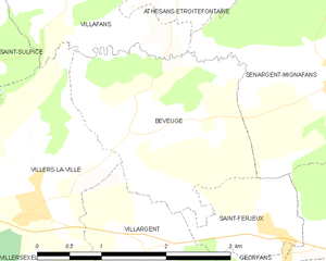
Beveuge
- commune in Haute-Saône, France
- Country:
- Postal Code: 70110
- Coordinates: 47° 33' 30" N, 6° 28' 58" E
- GPS tracks (wikiloc): [Link]
- Area: 5.18 sq km
- Population: 82

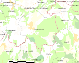
Courchaton
- commune in Haute-Saône, France
Hiking in Courchaton
As of my last knowledge update in October 2023, Courchaton doesn't appear to be a widely recognized hiking destination, so I may need more specific information on its location or features. However, if you are seeking hiking opportunities in lesser-known areas, there are a few general tips and considerations....
- Country:
- Postal Code: 70110
- Coordinates: 47° 30' 59" N, 6° 32' 25" E
- GPS tracks (wikiloc): [Link]
- Area: 13.53 sq km
- Population: 452


Oricourt
- commune in Haute-Saône, France
- Country:
- Postal Code: 70110
- Coordinates: 47° 35' 43" N, 6° 23' 35" E
- GPS tracks (wikiloc): [Link]
- Area: 3.65 sq km
- Population: 38

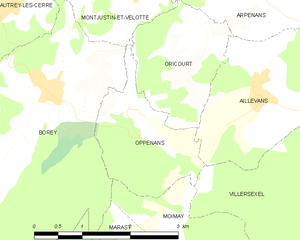
Oppenans
- commune in Haute-Saône, France
- Country:
- Postal Code: 70110
- Coordinates: 47° 35' 20" N, 6° 22' 49" E
- GPS tracks (wikiloc): [Link]
- Area: 3.57 sq km
- Population: 60

Mélecey
- commune in Haute-Saône, France
Hiking in Mélecey
Melécey is a charming commune located in the Côte-d'Or department in the Bourgogne-Franche-Comté region of east-central France. While it may not be as widely known as some larger hiking hotspots, it offers beautiful landscapes and a tranquil environment for hikers looking to explore nature away from the crowded trails....
- Country:
- Postal Code: 70110
- Coordinates: 47° 31' 10" N, 6° 29' 25" E
- GPS tracks (wikiloc): [Link]
- Area: 3.35 sq km
- Population: 154


Marast
- commune in Haute-Saône, France
- Country:
- Postal Code: 70110
- Coordinates: 47° 33' 27" N, 6° 22' 57" E
- GPS tracks (wikiloc): [Link]
- Area: 3.06 sq km
- Population: 47

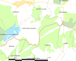
Pont-sur-l'Ognon
- commune in Haute-Saône, France
- Country:
- Postal Code: 70110
- Coordinates: 47° 31' 16" N, 6° 23' 16" E
- GPS tracks (wikiloc): [Link]
- Area: 4.16 sq km
- Population: 67


Mignavillers
- commune in Haute-Saône, France
- Country:
- Postal Code: 70400
- Coordinates: 47° 34' 50" N, 6° 33' 6" E
- GPS tracks (wikiloc): [Link]
- Area: 7.59 sq km
- Population: 337


Longevelle
- commune in Haute-Saône, France
- Country:
- Postal Code: 70110
- Coordinates: 47° 35' 24" N, 6° 26' 51" E
- GPS tracks (wikiloc): [Link]
- AboveSeaLevel: 115 м m
- Area: 4.1 sq km
- Population: 131

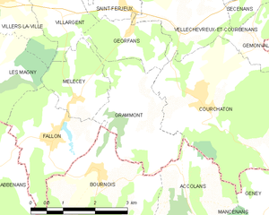
Grammont
- commune in Haute-Saône, France
Hiking in Grammont
Grammont, located in the Haute-Saône department in the region of Bourgogne-Franche-Comté, offers a variety of hiking opportunities that showcase the beautiful natural landscapes and rich cultural heritage of the area....
- Country:
- Postal Code: 70110
- Coordinates: 47° 30' 53" N, 6° 30' 59" E
- GPS tracks (wikiloc): [Link]
- Area: 5.94 sq km
- Population: 62


La Vergenne
- commune in Haute-Saône, France
- Country:
- Postal Code: 70200
- Coordinates: 47° 36' 39" N, 6° 31' 25" E
- GPS tracks (wikiloc): [Link]
- Area: 2.95 sq km
- Population: 122


Villargent
- commune in Haute-Saône, France
- Country:
- Postal Code: 70110
- Coordinates: 47° 32' 30" N, 6° 29' 9" E
- GPS tracks (wikiloc): [Link]
- Area: 2.86 sq km
- Population: 125


Villers-la-Ville
- commune in Haute-Saône, France
- Country:
- Postal Code: 70110
- Coordinates: 47° 32' 55" N, 6° 27' 43" E
- GPS tracks (wikiloc): [Link]
- Area: 5.87 sq km
- Population: 143


Vellechevreux-et-Courbenans
- commune in Haute-Saône, France
Hiking in Vellechevreux-et-Courbenans
Vellechevreux-et-Courbenans is a small commune located in the Bourgogne-Franche-Comté region of eastern France. While it may not be as widely known as other hiking destinations, it offers a charming experience for those looking to explore rural France....
- Country:
- Postal Code: 70110
- Coordinates: 47° 32' 24" N, 6° 32' 19" E
- GPS tracks (wikiloc): [Link]
- AboveSeaLevel: 288 м m
- Area: 9.14 sq km
- Population: 133


Saint-Sulpice
- commune in Haute-Saône, France
- Country:
- Postal Code: 70110
- Coordinates: 47° 33' 58" N, 6° 26' 51" E
- GPS tracks (wikiloc): [Link]
- Area: 3.53 sq km
- Population: 133


Saint-Ferjeux
- commune in Haute-Saône, France
- Country:
- Postal Code: 70110
- Coordinates: 47° 32' 37" N, 6° 30' 36" E
- GPS tracks (wikiloc): [Link]
- Area: 1.77 sq km
- Population: 78


Secenans
- commune in Haute-Saône, France
Hiking in Secenans
I’m sorry, but it appears there may be a typo in your query regarding "Secenans." If you meant "Sicily," "Sedona," or another specific hiking destination, please clarify, and I’d be happy to provide information on hiking in that area! If it is a specific local area or trail, please provide more details so I can assist you better....
- Country:
- Postal Code: 70400
- Coordinates: 47° 33' 12" N, 6° 34' 28" E
- GPS tracks (wikiloc): [Link]
- Area: 2.88 sq km
- Population: 176


Faymont
- commune in Haute-Saône, France
- Country:
- Postal Code: 70200
- Coordinates: 47° 36' 34" N, 6° 35' 39" E
- GPS tracks (wikiloc): [Link]
- Area: 7.99 sq km
- Population: 261

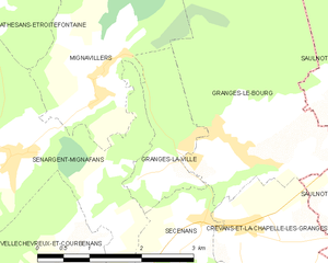
Granges-la-Ville
- commune in Haute-Saône, France
- Country:
- Postal Code: 70400
- Coordinates: 47° 34' 0" N, 6° 34' 21" E
- GPS tracks (wikiloc): [Link]
- Area: 2.61 sq km
- Population: 193

Villersexel
- commune in Haute-Saône, France
- Country:
- Postal Code: 70110
- Coordinates: 47° 33' 2" N, 6° 26' 0" E
- GPS tracks (wikiloc): [Link]
- Area: 13.19 sq km
- Population: 1445
- Web site: [Link]