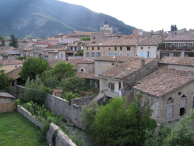
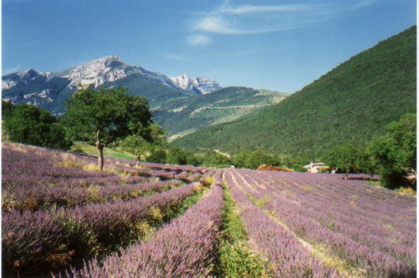
Romeyer (Romeyer)

- commune in Drôme, France
 Hiking in Romeyer
Romeyer is a beautiful area in the French Alps, often praised for its stunning natural beauty, diverse landscapes, and excellent hiking opportunities. While it may not be as widely known as some other hiking destinations in France, it offers a great experience for those looking to explore the outdoors.
Hiking Trails
-
Variety of Trails: Romeyer features a range of hiking trails suitable for different skill levels. You can find well-marked paths that lead to breathtaking viewpoints, rugged terrains, and serene valleys.
-
Scenic Views: Many hikes in the area offer panoramic views of the surrounding mountains and valleys, making for great photo opportunities.
-
Wildlife: The area is home to various flora and fauna. Hikers might spot different species of birds, deer, and other wildlife, especially in the early morning or late afternoon.
Best Time to Hike
- Spring and Summer: The best time for hiking in Romeyer is from late spring to early fall. The weather is generally mild, and the trails are usually clear and accessible.
- Fall: Autumn can also be a beautiful time to hike, as the foliage changes colors, creating a picturesque landscape.
Preparation
-
Equipment: Wear suitable footwear and carry essentials like water, snacks, a first aid kit, and a map or GPS device. Layered clothing is advisable since temperatures can fluctuate throughout the day.
-
Safety: Always inform someone of your plans before heading out on a hike. Familiarize yourself with the trail difficulty and length, and choose a hike that matches your fitness level.
Local Amenities
After a day of hiking, you can enjoy local cuisine in nearby villages or towns. Look for traditional French Alpine dishes, which can be a delightful way to end your hiking adventures.
Enjoy your hiking experience in Romeyer and make sure to take in the stunning beauty that this region has to offer!
- Country:

- Postal Code: 26150
- Coordinates: 44° 46' 46" N, 5° 24' 32" E


- GPS tracks (wikiloc): [Link]
- Area: 41.46 sq km
- Population: 203
- Wikipedia en: wiki(en)
- Wikipedia: wiki(fr)
- Wikidata storage: Wikidata: Q1094795
- Wikipedia Commons Category: [Link]
- Freebase ID: [/m/03mhjpd]
- GeoNames ID: Alt: [6616263]
- SIREN number: [212602825]
- BnF ID: [152531425]
- Pleiades ID: [167886]
- INSEE municipality code: 26282
Shares border with regions:


Laval-d'Aix
- commune in Drôme, France
Hiking in Laval-d'Aix
Laval-d'Aix, located in the Auvergne-Rhône-Alpes region of France, offers stunning scenic beauty and a variety of hiking opportunities. Here are some key points to consider:...
- Country:
- Postal Code: 26150
- Coordinates: 44° 42' 48" N, 5° 25' 53" E
- GPS tracks (wikiloc): [Link]
- Area: 20.05 sq km
- Population: 124


Gresse-en-Vercors
- commune in Isère, France
Hiking in Gresse-en-Vercors
Gresse-en-Vercors is a charming village located in the Vercors Regional Natural Park in the French Alps. It’s an exceptional area for hiking, offering a variety of trails that cater to a range of skill levels, from beginners to experienced hikers. Here are some highlights and things to consider when hiking in Gresse-en-Vercors:...
- Country:
- Postal Code: 38650
- Coordinates: 44° 54' 8" N, 5° 34' 0" E
- GPS tracks (wikiloc): [Link]
- Area: 81.13 sq km
- Population: 395
- Web site: [Link]

Die
- commune in Drôme, France
Hiking in Die
Die, located in the Drôme department of the Auvergne-Rhône-Alpes region in southeastern France, is a fantastic destination for hiking enthusiasts. This charming town is nestled in the Vercors Massif, surrounded by stunning mountainous landscapes, vineyards, and the richly diverse flora and fauna of the region....
- Country:
- Postal Code: 26150
- Coordinates: 44° 45' 13" N, 5° 22' 13" E
- GPS tracks (wikiloc): [Link]
- Area: 57.28 sq km
- Population: 4576
- Web site: [Link]


Chichilianne
- commune in Isère, France
Hiking in Chichilianne
Chichilianne is a charming village located in the Vercors Regional Natural Park in southeastern France, often referred to as the "Gateway to the Vercors." The area is known for its stunning natural landscapes, including rugged mountains, deep valleys, and diverse flora and fauna, making it an excellent destination for hiking enthusiasts....
- Country:
- Postal Code: 38930
- Coordinates: 44° 48' 42" N, 5° 34' 20" E
- GPS tracks (wikiloc): [Link]
- Area: 62.48 sq km
- Population: 284
- Web site: [Link]
Saint-Agnan-en-Vercors
- commune in Drôme, France
Hiking in Saint-Agnan-en-Vercors
Saint-Agnan-en-Vercors is a charming village located in the Vercors Massif, part of the French Pre-Alps. This area is known for its stunning landscapes, rich biodiversity, and extensive network of hiking trails, making it a fantastic destination for both novice and experienced hikers....
- Country:
- Postal Code: 26420
- Coordinates: 44° 56' 8" N, 5° 25' 52" E
- GPS tracks (wikiloc): [Link]
- Area: 84.21 sq km
- Population: 397

Chamaloc
- commune in Drôme, France
Hiking in Chamaloc
Chamaloc, located in the Île-de-France region of France, is a lesser-known destination for hiking enthusiasts. While it may not be as famous as other hiking hotspots in France, it offers beautifully scenic trails and a peaceful escape into nature. Here’s what you need to know about hiking in and around Chamaloc:...
- Country:
- Postal Code: 26150
- Coordinates: 44° 47' 55" N, 5° 23' 2" E
- GPS tracks (wikiloc): [Link]
- Area: 21.89 sq km
- Population: 129