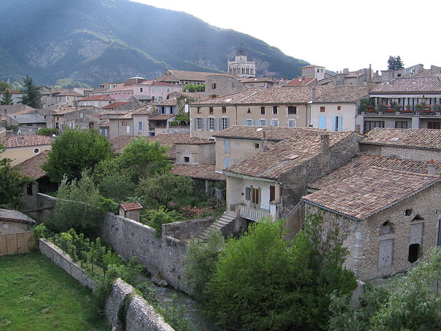
Marignac-en-Diois (Marignac-en-Diois)

- commune in Drôme, France
 Hiking in Marignac-en-Diois
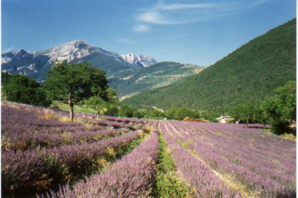
Marignac-en-Diois is a picturesque village located in the Drôme department of southeastern France, nestled in the heart of the Diois region. This area is known for its stunning natural landscapes, making it an excellent destination for hiking enthusiasts.
Hiking Trails and Routes
-
The Diois Heritage Trail:
- This trail offers a mix of cultural and natural exploration, taking you through charming villages, vineyards, and stunning views of the surrounding mountains, including the Vercors and the Alps.
-
Climbing to the Montagne de Couspeau:
- This hike provides beautiful panoramic views and is ideal for those looking for a moderate challenge. The trail winds through fragrant pine forests and rocky terrain.
-
Val de Ruzé:
- A more relaxed hike suitable for families, this path meanders along the river and takes you through enchanting woodlands and open meadows, offering chances for wildlife spotting.
-
Cascades de la Pisse:
- A picturesque trail leading to beautiful waterfalls. The route can be moderately steep in some areas but rewards hikers with refreshing views and a lovely picnic spot.
Best Times to Hike
- Spring (April to June): Ideal for wildflowers and pleasant temperatures.
- Fall (September to October): Spectacular autumn colors and comfortable weather make this a great time for hiking.
- Summer: Be cautious of the heat; it’s best to hike early in the morning or later in the evening.
What to Bring
- Water: Stay hydrated, especially during summer hikes.
- Snacks: High-energy foods are great for refreshing during longer hikes.
- Proper Footwear: Sturdy hiking boots or shoes are recommended due to varied terrain.
- Map or GPS: To help navigate through the trails, as well as a small first-aid kit for emergencies.
Local Tips
- Check local weather conditions before heading out, as they can change quickly in this mountainous region.
- Respect the natural environment: Stick to marked trails and practice Leave No Trace principles.
Hiking in Marignac-en-Diois not only offers physical challenges but also a chance to immerse yourself in the local culture and enjoy the breathtaking scenery of the French Alps. Whether a seasoned hiker or a casual walker, you'll find trails that cater to all levels of experience here.
- Country:

- Postal Code: 26150
- Coordinates: 44° 48' 9" N, 5° 20' 1" E


- GPS tracks (wikiloc): [Link]
- Area: 18.26 sq km
- Population: 204
- Wikipedia en: wiki(en)
- Wikipedia: wiki(fr)
- Wikidata storage: Wikidata: Q763873
- Wikipedia Commons Category: [Link]
- Freebase ID: [/m/03mhj02]
- GeoNames ID: Alt: [6430119]
- SIREN number: [212601751]
- BnF ID: [15253036z]
- INSEE municipality code: 26175
Shares border with regions:


Saint-Andéol
- commune in Drôme, France
Hiking in Saint-Andéol
Saint-Andéol, located in the Drôme department of southeastern France, is a picturesque commune that offers a variety of hiking opportunities amidst beautiful landscapes. The region is characterized by diverse topography, including hills, forests, and valleys, making it ideal for both casual walkers and more experienced hikers....
- Country:
- Postal Code: 26150
- Coordinates: 44° 48' 39" N, 5° 16' 5" E
- GPS tracks (wikiloc): [Link]
- Area: 13.37 sq km
- Population: 78

Die
- commune in Drôme, France
Hiking in Die
Die, located in the Drôme department of the Auvergne-Rhône-Alpes region in southeastern France, is a fantastic destination for hiking enthusiasts. This charming town is nestled in the Vercors Massif, surrounded by stunning mountainous landscapes, vineyards, and the richly diverse flora and fauna of the region....
- Country:
- Postal Code: 26150
- Coordinates: 44° 45' 13" N, 5° 22' 13" E
- GPS tracks (wikiloc): [Link]
- Area: 57.28 sq km
- Population: 4576
- Web site: [Link]


Vassieux-en-Vercors
- commune in Drôme, France
Hiking in Vassieux-en-Vercors
Vassieux-en-Vercors is a beautiful village located in the Vercors Regional Natural Park in France, known for its stunning natural landscapes and outdoor activities, especially hiking. The area is characterized by its dramatic limestone cliffs, dense forests, and rich biodiversity, making it an ideal destination for hikers of all levels....
- Country:
- Postal Code: 26420
- Coordinates: 44° 53' 43" N, 5° 22' 13" E
- GPS tracks (wikiloc): [Link]
- Area: 48.25 sq km
- Population: 318
- Web site: [Link]
Ponet-et-Saint-Auban
- commune in Drôme, France
Hiking in Ponet-et-Saint-Auban
Ponet-et-Saint-Auban, located in the Drôme department of southeastern France, offers a beautiful landscape perfect for hiking enthusiasts. The area is characterized by its diverse terrain, ranging from rolling hills and dense forests to rocky outcrops, providing plenty of opportunities for exploration and adventure....
- Country:
- Postal Code: 26150
- Coordinates: 44° 47' 14" N, 5° 18' 59" E
- GPS tracks (wikiloc): [Link]
- Area: 13.21 sq km
- Population: 127

Chamaloc
- commune in Drôme, France
Hiking in Chamaloc
Chamaloc, located in the Île-de-France region of France, is a lesser-known destination for hiking enthusiasts. While it may not be as famous as other hiking hotspots in France, it offers beautifully scenic trails and a peaceful escape into nature. Here’s what you need to know about hiking in and around Chamaloc:...
- Country:
- Postal Code: 26150
- Coordinates: 44° 47' 55" N, 5° 23' 2" E
- GPS tracks (wikiloc): [Link]
- Area: 21.89 sq km
- Population: 129
Saint-Julien-en-Quint
- commune in Drôme, France
Hiking in Saint-Julien-en-Quint
Saint-Julien-en-Quint is a beautiful commune located in the Rhône-Alpes region of France, known for its stunning natural landscapes and outdoor recreational opportunities. Here are some key points about hiking in this area:...
- Country:
- Postal Code: 26150
- Coordinates: 44° 50' 16" N, 5° 17' 32" E
- GPS tracks (wikiloc): [Link]
- Area: 47.35 sq km
- Population: 157