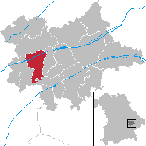
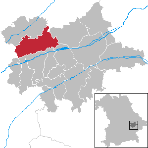
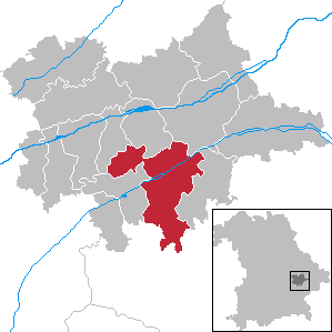
Dingolfing-Landau (Landkreis Dingolfing-Landau)

- district in Bavaria, Germany
 Hiking in Dingolfing-Landau
Dingolfing-Landau, located in Bavaria, Germany, offers a variety of hiking opportunities for enthusiasts of all levels. The region is known for its picturesque landscapes, charming villages, and diverse flora and fauna. Here are some highlights of hiking in Dingolfing-Landau:
Scenic Trails
-
Isar Valley Trails: The Isar River cuts through the region, offering several scenic trails along its banks. These paths provide tranquil views and a chance to enjoy nature.
-
Nature Parks: The area is home to parts of the Bavarian Forest and other protected nature reserves, where you can find well-marked trails that wind through forests and meadows.
-
The Landauer Wald: This forest area features numerous trails that are suitable for hiking, cycling, and nature walks. The trails vary in difficulty, making them accessible for families and experienced hikers alike.
-
Cultural Trails: Some trails in the area also highlight the rich history and culture of Dingolfing-Landau, taking you past historical sites, churches, and traditional Bavarian farms.
Trail Recommendations
- Dingolfing to Landau: A popular trail connecting the two towns, offering a mix of nature and local culture.
- Hiking Circuits: Look for local hiking circuits that combine multiple trails, allowing for longer hikes that can include picnics and rest stops in scenic areas.
Tips for Hiking in Dingolfing-Landau
- Maps and Guides: It's advisable to carry a detailed map or download hiking apps with offline features to navigate the trails.
- Check Weather: Bavaria's weather can be unpredictable. Always check for weather updates and dress in layers.
- Local Regulations: Be mindful of local regulations regarding trail usage, especially in protected areas.
- Hydrate and Snack: Carry enough water and snacks, particularly on longer hikes where amenities may be sparse.
Seasonal Considerations
- Spring and Summer: Ideal for hiking, the trails are vibrant with wildflowers and wildlife.
- Autumn: A wonderful time for hiking, with stunning fall foliage.
- Winter: Some trails may be suited for winter hiking or snowshoeing, but check conditions beforehand.
Overall, Dingolfing-Landau is a lovely area for hiking, with a good mix of natural beauty and cultural experiences waiting to be explored. Whether you're looking for a leisurely stroll or a challenging hike, you'll find options to suit your preferences!
- Country:

- Capital: Dingolfing
- Licence Plate Code: DGF
- Coordinates: 48° 40' 12" N, 12° 34' 48" E


- GPS tracks (wikiloc): [Link]
- AboveSeaLevel: 372 м m
- Area: 878.00 sq km
- Population: 75517
- Web site: http://www.landkreis-dingolfing-landau.de
- Wikipedia en: wiki(en)
- Wikipedia: wiki(de)
- Wikidata storage: Wikidata: Q10480
- Wikipedia Commons Category: [Link]
- Freebase ID: [/m/01l5wk]
- GeoNames ID: Alt: [3220808]
- VIAF ID: Alt: [236782929]
- OSM relation ID: [62707]
- GND ID: Alt: [4012352-2]
- archINFORM location ID: [2383]
- TGN ID: [7077310]
- Bavarikon ID: [ODB_A00001679]
- ISNI: Alt: [0000 0001 1941 093X]
- NUTS code: [DE22C]
- Ringgold ID: [40193]
- BabelNet ID: [01852110n]
- German district key: 09279
Includes regions:

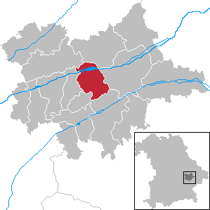
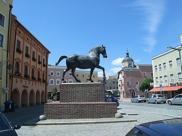
Dingolfing
- town in Bavaria, Germany
Hiking in Dingolfing
Dingolfing, located in Bavaria, Germany, offers a variety of hiking opportunities that showcase the picturesque landscapes and natural beauty of the region. Here are some highlights for hiking enthusiasts:...
- Country:
- Postal Code: 84130
- Local Dialing Code: 08732; 08731
- Licence Plate Code: DGF
- Coordinates: 48° 38' 0" N, 12° 30' 0" E
- GPS tracks (wikiloc): [Link]
- AboveSeaLevel: 357 м m
- Area: 44 sq km
- Population: 19145
- Web site: [Link]

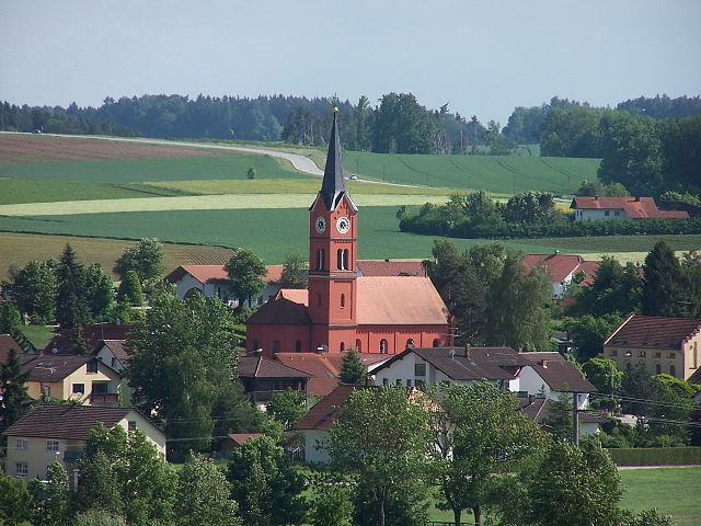
Eichendorf
- municipality of Germany
Hiking in Eichendorf
Eichendorf, located in Bavaria, Germany, is a charming area surrounded by picturesque landscapes, making it a great destination for hiking enthusiasts. Here are some highlights and information to consider if you're planning to hike in and around Eichendorf:...
- Country:
- Postal Code: 94428
- Local Dialing Code: 09956; 09952; 09937; 08547
- Licence Plate Code: DGF
- Coordinates: 48° 38' 0" N, 12° 51' 0" E
- GPS tracks (wikiloc): [Link]
- AboveSeaLevel: 355 м m
- Area: 98.19 sq km
- Population: 6236
- Web site: [Link]


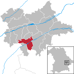
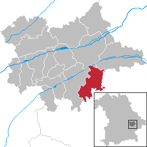
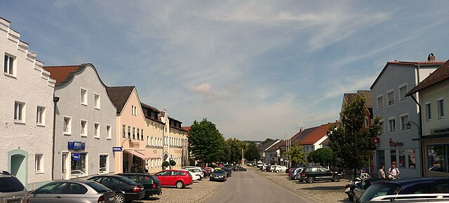
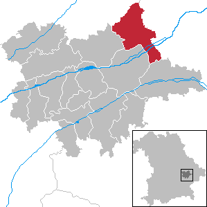
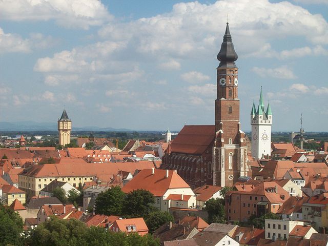
Landau an der Isar
- municipality of Germany
Hiking in Landau an der Isar
Landau an der Isar, located in Bavaria, Germany, offers a charming setting for hiking enthusiasts. The region is characterized by its picturesque landscapes, including rolling hills, lush forests, and scenic riverbanks. Here are some highlights and tips for hiking in and around Landau an der Isar:...
- Country:
- Postal Code: 94405
- Local Dialing Code: 09951
- Coordinates: 48° 40' 30" N, 12° 41' 29" E
- GPS tracks (wikiloc): [Link]
- AboveSeaLevel: 339 м m
- Area: 84.39 sq km
- Population: 11299
- Web site: [Link]


Pilsting
- municipality of Germany
Hiking in Pilsting
Pilsting is a charming town located in Bavaria, Germany, and while it may not be the most well-known hiking destination, there are several nearby natural areas and trails that provide great opportunities for hiking enthusiasts....
- Country:
- Postal Code: 94431
- Local Dialing Code: 09953
- Licence Plate Code: DGF
- Coordinates: 48° 42' 0" N, 12° 39' 0" E
- GPS tracks (wikiloc): [Link]
- AboveSeaLevel: 341 м m
- Area: 71.2 sq km
- Population: 5570
- Web site: [Link]

Marklkofen
- municipality of Germany
Hiking in Marklkofen
Marklkofen is a beautiful area in Bavaria, Germany, that offers some lovely hiking opportunities. While it might not be as widely recognized as some of the larger hiking destinations in Germany, it provides a pleasant experience for those looking to explore the scenic countryside....
- Country:
- Postal Code: 84163
- Local Dialing Code: 08732
- Licence Plate Code: DGF
- Coordinates: 48° 33' 0" N, 12° 34' 0" E
- GPS tracks (wikiloc): [Link]
- AboveSeaLevel: 408 м m
- Area: 40.72 sq km
- Population: 3365
- Web site: [Link]

Mamming
- municipality of Germany
Hiking in Mamming
Mamming is a charming village in Bavaria, Germany, known for its picturesque surroundings and natural beauty. While it's not as widely recognized for hiking as some other regions, there are opportunities to explore the landscapes nearby. Here are some tips and highlights for hiking in and around Mamming:...
- Country:
- Postal Code: 94437
- Local Dialing Code: 09955
- Licence Plate Code: DGF
- Coordinates: 48° 39' 0" N, 12° 36' 0" E
- GPS tracks (wikiloc): [Link]
- AboveSeaLevel: 368 м m
- Area: 41.48 sq km
- Population: 2309
- Web site: [Link]


Niederviehbach
- municipality of Germany
Hiking in Niederviehbach
Niederviehbach is a charming village located in Bavaria, Germany, known for its beautiful natural landscapes and picturesque scenery, making it a delightful area for hiking enthusiasts. The region offers various hiking trails that cater to different skill levels and preferences, often featuring scenic views of the surrounding countryside, forests, and rivers....
- Country:
- Postal Code: 84183
- Local Dialing Code: 08702
- Licence Plate Code: DGF
- Coordinates: 48° 37' 0" N, 12° 23' 0" E
- GPS tracks (wikiloc): [Link]
- AboveSeaLevel: 392 м m
- Area: 29.62 sq km
- Population: 1901
- Web site: [Link]

Moosthenning
- municipality of Germany
Hiking in Moosthenning
Moosthenning is a quaint village located in Bavaria, Germany, surrounded by picturesque landscapes that are ideal for hiking enthusiasts. The region features a mix of natural beauty, including rolling hills, forests, and meadows, making it a great spot for various hiking trails suitable for different skill levels....
- Country:
- Postal Code: 84164
- Local Dialing Code: 08731
- Licence Plate Code: DGF
- Coordinates: 48° 41' 0" N, 12° 30' 0" E
- GPS tracks (wikiloc): [Link]
- AboveSeaLevel: 368 м m
- Area: 70.4 sq km
- Population: 3736
- Web site: [Link]

Mengkofen
- municipality of Germany
Hiking in Mengkofen
Mengkofen, located in Bavaria, Germany, offers beautiful scenic landscapes that are ideal for hiking enthusiasts. The region features a mix of rolling hills, woodlands, and agricultural fields, providing a tranquil environment for outdoor activities....
- Country:
- Postal Code: 84152
- Local Dialing Code: 09427; 08774; 08733
- Licence Plate Code: DGF
- Coordinates: 48° 43' 0" N, 12° 26' 0" E
- GPS tracks (wikiloc): [Link]
- AboveSeaLevel: 398 м m
- Area: 84.65 sq km
- Population: 4326
- Web site: [Link]


Frontenhausen
- municipality of Germany
Hiking in Frontenhausen
Frontenhausen, a small town located in Bavaria, Germany, is nestled in a picturesque landscape that offers various opportunities for hiking enthusiasts. Here are some aspects to consider if you're planning a hiking trip in or around Frontenhausen:...
- Country:
- Postal Code: 84160
- Local Dialing Code: 08732
- Licence Plate Code: DGF
- Coordinates: 48° 33' 0" N, 12° 32' 0" E
- GPS tracks (wikiloc): [Link]
- AboveSeaLevel: 412 м m
- Area: 30.43 sq km
- Population: 3151
- Web site: [Link]

Simbach
- municipality of Germany
Hiking in Simbach
Simbach, located in the Dingolfing-Landau district of Bavaria, Germany, is a charming area surrounded by picturesque landscapes that are ideal for hiking. Here are some highlights and tips for hiking in this region:...
- Country:
- Postal Code: 94436
- Local Dialing Code: 09954
- Licence Plate Code: DGF
- Coordinates: 48° 34' 0" N, 12° 45' 0" E
- GPS tracks (wikiloc): [Link]
- AboveSeaLevel: 415 м m
- Area: 51.19 sq km
- Population: 3392
- Web site: [Link]
Reisbach
- municipality of Germany
Hiking in Reisbach
Reisbach, located near Vils in Bavaria, Germany, offers beautiful natural landscapes that are perfect for hiking enthusiasts. The region is characterized by its rolling hills, scenic valleys, and picturesque views of the Alps, providing ample opportunities for both casual walkers and more experienced hikers....
- Country:
- Postal Code: 94419
- Local Dialing Code: 08734
- Licence Plate Code: DGF
- Coordinates: 48° 33' 56" N, 12° 37' 53" E
- GPS tracks (wikiloc): [Link]
- AboveSeaLevel: 425 м m
- Area: 94.19 sq km
- Population: 6258
- Web site: [Link]

Wallersdorf
- municipality of Germany
Hiking in Wallersdorf
Wallersdorf is a charming town located in Bavaria, Germany, known for its picturesque landscapes and scenic hiking trails. The region around Wallersdorf offers various hiking opportunities that cater to different levels of experience, from easy walks to more challenging hikes. Here’s what you can expect when hiking in and around Wallersdorf:...
- Country:
- Postal Code: 94522
- Local Dialing Code: 09933
- Licence Plate Code: DGF
- Coordinates: 48° 44' 0" N, 12° 45' 0" E
- GPS tracks (wikiloc): [Link]
- AboveSeaLevel: 334 м m
- Area: 71.16 sq km
- Population: 5646
- Web site: [Link]


Loiching
- municipality of Germany
Hiking in Loiching
Loiching is a quaint town located in the Lower Bavaria region of Germany, surrounded by beautiful natural landscapes that offer excellent hiking opportunities. The area is characterized by rolling hills, forests, and fields, making it suitable for hikers of various skill levels. Here are some key points to consider when hiking in and around Loiching:...
- Country:
- Postal Code: 84180
- Local Dialing Code: 08702; 08732; 08744; 08731
- Licence Plate Code: DGF
- Coordinates: 48° 37' 0" N, 12° 26' 0" E
- GPS tracks (wikiloc): [Link]
- AboveSeaLevel: 385 м m
- Area: 38.89 sq km
- Population: 2871
- Web site: [Link]


Gottfrieding
- municipality of Germany
Hiking in Gottfrieding
Gottfrieding is a small municipality located in Bavaria, Germany. While it may not be as well-known for hiking as some larger regions, it offers access to scenic Bavarian landscapes and is in close proximity to several hiking trails and natural areas....
- Country:
- Postal Code: 84177
- Local Dialing Code: 08731
- Licence Plate Code: DGF
- Coordinates: 48° 39' 0" N, 12° 32' 0" E
- GPS tracks (wikiloc): [Link]
- AboveSeaLevel: 369 м m
- Area: 27.06 sq km
- Population: 1601
- Web site: [Link]
Shares border with regions:

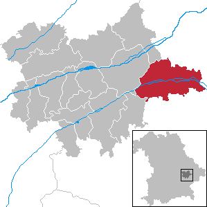
Landshut
- district in Bavaria, Germany
Hiking in Landshut
Landshut district, located in Bavaria, Germany, offers a variety of hiking opportunities that cater to different skill levels and preferences. The landscape is characterized by rolling hills, picturesque villages, and lush forests, providing a beautiful backdrop for outdoor activities....
- Country:
- Capital: Landshut
- Licence Plate Code: LA
- Coordinates: 48° 34' 14" N, 12° 10' 50" E
- GPS tracks (wikiloc): [Link]
- AboveSeaLevel: 383 м m
- Area: 1348 sq km
- Population: 115644
- Web site: [Link]
Rottal-Inn
- district of Bavaria, Germany
Hiking in Rottal-Inn
Rottal-Inn, located in Bavaria, Germany, is a picturesque area known for its natural beauty and diverse landscapes, making it an excellent destination for hiking enthusiasts. The region is characterized by rolling hills, lush forests, and charming villages, providing a variety of hiking trails suitable for all skill levels. Here are some highlights to consider when hiking in Rottal-Inn:...
- Country:
- Capital: Pfarrkirchen
- Licence Plate Code: PAN; VIB; GRI; EG
- Coordinates: 48° 25' 12" N, 12° 55' 12" E
- GPS tracks (wikiloc): [Link]
- AboveSeaLevel: 461 м m
- Area: 1.28 sq km
- Population: 104013
- Web site: [Link]
Straubing-Bogen
- district of Bavaria, Germany
Hiking in Straubing-Bogen
Straubing-Bogen is a beautiful district located in Bavaria, Germany, known for its picturesque landscapes and varied terrain, making it a great destination for hiking enthusiasts. Here are some highlights and tips for hiking in the region:...
- Country:
- Capital: Straubing
- Licence Plate Code: MAL; BOG; SR
- Coordinates: 48° 55' 12" N, 12° 34' 48" E
- GPS tracks (wikiloc): [Link]
- AboveSeaLevel: 337 м m
- Area: 1202.24 sq km
- Population: 81062
- Web site: [Link]


Deggendorf
- district in Bavaria, Germany
Hiking in Deggendorf
Deggendorf, located in Bavaria, Germany, is a fantastic region for hiking enthusiasts. Nestled at the edge of the Bavarian Forest National Park and alongside the Danube River, it boasts a variety of landscapes and trails suitable for all skill levels....
- Country:
- Capital: Deggendorf
- Licence Plate Code: DEG
- Coordinates: 48° 49' 48" N, 13° 0' 0" E
- GPS tracks (wikiloc): [Link]
- AboveSeaLevel: 309 м m
- Area: 861.00 sq km
- Population: 115005
- Web site: [Link]