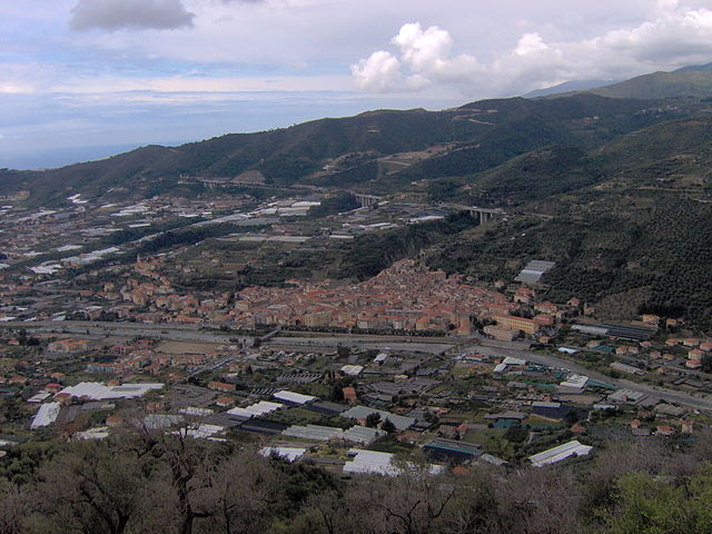
Dolcedo (Dolcedo)
.svg)
- Italian comune
 Hiking in Dolcedo
Dolcedo, a charming village located in the Italian Riviera region of Liguria, offers a great backdrop for hiking enthusiasts. Nestled in a picturesque valley, surrounded by ancient olive groves and Mediterranean vegetation, Dolcedo provides an array of hiking trails that cater to various skill levels.
Popular Hiking Trails in Dolcedo:
-
From Dolcedo to Isolabona:
- Distance: Approximately 7 km round trip.
- Difficulty: Moderate.
- Highlights: This trail takes you through lush landscapes with stunning views of the valleys and hills. You’ll encounter traditional stone villages and can enjoy the local flora and fauna.
-
The Olive Trail:
- Distance: Varies depending on the route chosen.
- Difficulty: Easy to moderate.
- Highlights: A scenic walk through olive groves that showcases the agricultural heritage of the region. This trail is ideal for families and offers beautiful views of the surrounding countryside.
-
The Via Aureliana:
- Distance: Around 10 km.
- Difficulty: Moderate to difficult.
- Highlights: Following an ancient Roman route, this trail leads through spectacular landscapes and offers breathtaking views of the coastline and mountains.
-
Dolcedo to Monte Faudo:
- Distance: Approximately 12 km round trip.
- Difficulty: Challenging.
- Highlights: This hike ascends to Monte Faudo, where you can enjoy panoramic views of the entire coastal area. It's a rewarding hike for those looking for a bit more of a challenge.
Tips for Hiking in Dolcedo:
- Best Time to Hike: The ideal seasons for hiking in Dolcedo are spring (April to June) and autumn (September to October) when the weather is mild and the landscapes are vibrant.
- What to Bring: Always carry plenty of water, snacks, a map or GPS device, sunscreen, and wear suitable footwear. A basic first-aid kit can also be helpful.
- Local Regulations: Be sure to respect local wildlife and trails. Stay on marked paths and avoid picking plants.
- Cultural Aspects: Take the time to enjoy Dolcedo’s historic architecture and local cuisine after a hike; the village is known for its traditional Ligurian dishes.
Dolcedo’s combination of stunning natural beauty and rich cultural heritage makes it a unique destination for hikers looking to explore the Italian landscape. Happy hiking!
- Country:

- Postal Code: 18020
- Local Dialing Code: 0183
- Licence Plate Code: IM
- Coordinates: 43° 54' 25" N, 7° 57' 6" E


- GPS tracks (wikiloc): [Link]
- AboveSeaLevel: 75 м m
- Area: 19.8 sq km
- Population: 1385
- Web site: http://www.comune.dolcedo.im.it
- Wikipedia en: wiki(en)
- Wikipedia: wiki(it)
- Wikidata storage: Wikidata: Q269013
- Wikipedia Commons Category: [Link]
- Freebase ID: [/m/0gbyp9]
- GeoNames ID: Alt: [6537039]
- OSM relation ID: [42721]
- UN/LOCODE: [ITDCO]
- ISTAT ID: 008030
- Italian cadastre code: D319
Shares border with regions:

Imperia
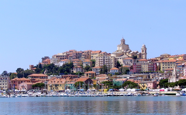
- coastal city and comune in the region of Liguria, Italy
Hiking in Imperia
Imperia, located on the beautiful Italian Riviera in the Liguria region, offers a variety of hiking opportunities that showcase its stunning coastal landscapes, charming villages, and lush countryside. Here are some highlights and tips for hiking in Imperia:...
- Country:
- Postal Code: 18100
- Local Dialing Code: 0183
- Licence Plate Code: IM
- Coordinates: 43° 53' 11" N, 8° 1' 47" E
- GPS tracks (wikiloc): [Link]
- AboveSeaLevel: 10 м m
- Area: 45 sq km
- Population: 41999
- Web site: [Link]


Badalucco
- Italian comune
Hiking in Badalucco
Badalucco is a charming village located in the province of Imperia, in the Liguria region of Italy. Nestled in the foothills of the Alps, it offers a number of hiking opportunities that provide stunning views of the surrounding mountains and the nearby coastline....
- Country:
- Postal Code: 18010
- Local Dialing Code: 0184
- Licence Plate Code: IM
- Coordinates: 43° 54' 57" N, 7° 50' 49" E
- GPS tracks (wikiloc): [Link]
- AboveSeaLevel: 179 м m
- Area: 16.1 sq km
- Population: 1123
- Web site: [Link]


Civezza
- Italian comune
Hiking in Civezza
Civezza is a charming village located in the Italian region of Liguria, near the coast and not far from the well-known town of San Remo. The area around Civezza is characterized by its beautiful landscapes, olive groves, and scenic views of the Mediterranean Sea, making it a fantastic destination for hiking enthusiasts....
- Country:
- Postal Code: 18017
- Local Dialing Code: 0183
- Licence Plate Code: IM
- Coordinates: 43° 52' 46" N, 7° 57' 4" E
- GPS tracks (wikiloc): [Link]
- AboveSeaLevel: 222 м m
- Area: 3.88 sq km
- Population: 599
- Web site: [Link]


Pietrabruna
- Italian comune
Hiking in Pietrabruna
Pietrabruna is a picturesque village located in the province of Imperia in the Italian region of Liguria. Nestled in the hills above the coastline, it offers stunning views and a variety of hiking opportunities that cater to different skill levels. Here are some key points about hiking in Pietrabruna:...
- Country:
- Postal Code: 18010
- Local Dialing Code: 0183
- Licence Plate Code: IM
- Coordinates: 43° 53' 23" N, 7° 54' 12" E
- GPS tracks (wikiloc): [Link]
- AboveSeaLevel: 400 м m
- Area: 10.22 sq km
- Population: 472
- Web site: [Link]


Prelà
- Italian comune
Hiking in Prelà
Prelà is a charming village located in the Liguria region of Italy, known for its lush landscapes and proximity to the beautiful Italian Riviera. Hiking in and around Prelà offers a range of experiences, from gentle walks through olive groves to more challenging trails with stunning views of the surrounding mountains and coastline....
- Country:
- Postal Code: 18020
- Local Dialing Code: 0183
- Licence Plate Code: IM
- Coordinates: 43° 55' 26" N, 7° 54' 33" E
- GPS tracks (wikiloc): [Link]
- AboveSeaLevel: 151 м m
- Area: 14.8 sq km
- Population: 498
- Web site: [Link]

Taggia
- Italian comune
Hiking in Taggia
Taggia is a charming town located in the Liguria region of Italy, known for its rich history, traditional olive production, and beautiful landscapes. Hiking around Taggia offers a variety of trails that cater to different skill levels, displaying the stunning scenery of the Italian Riviera, hills, and valleys....
- Country:
- Postal Code: 18018
- Local Dialing Code: 0184
- Licence Plate Code: IM
- Coordinates: 43° 50' 38" N, 7° 51' 3" E
- GPS tracks (wikiloc): [Link]
- AboveSeaLevel: 39 м m
- Area: 31.36 sq km
- Population: 14003
- Web site: [Link]


Vasia
- Italian comune
Hiking in Vasia
Vasia, located in the Liguria region of Italy, is a charming destination for hikers looking to explore picturesque landscapes and enjoy the serenity of nature. The area offers a variety of trails suitable for different skill levels, ranging from leisurely walks to more challenging hikes....
- Country:
- Postal Code: 18020
- Local Dialing Code: 0183
- Licence Plate Code: IM
- Coordinates: 43° 56' 0" N, 7° 57' 16" E
- GPS tracks (wikiloc): [Link]
- AboveSeaLevel: 385 м m
- Area: 11.15 sq km
- Population: 405
- Web site: [Link]